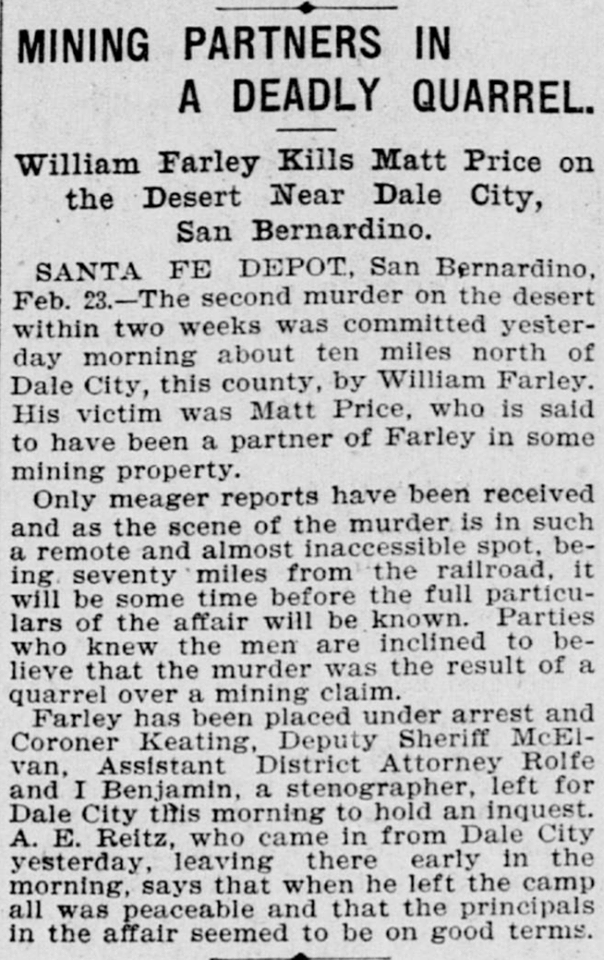
William Farley Kills Matt Price on the Desert Near Dale City, San Bernardino.
San Francisco Call – February 24, 1898
SANTA FE DEPOT, San Bernardino, Feb. 23. — The second murder on the desert within two weeks was committed yesterday morning about ten miles north of Dale City, this county, by William Farley. His victim was Matt Price, who is said to have been a partner of Farley in some mining property.
Only meager reports have been received and as the scene of the murder is in such a remote and almost inaccessible spot, being seventy miles from the railroad, it will be some time before the full particulars of the affair will be known. Parties who knew the men are inclined to believe that the murder was the result of a quarrel over a mining claim.
Farley has been placed under arrest and Coroner Keating, Deputy Sheriff McElvan. Assistant District Attorney Rolfe and I Benjamin, a stenographer, left for Dale City tin’s morning to hold an inquest. A. E. Reitz, who came in from Dale City yesterday, leaving there early in the morning, says that when he left the camp all was peaceable and that the principals in the affair seemed to be on good terms.
Ted Hosung was leaning against the counter of the Van Bresson Hotel in Daggett, one night, talking to the clerk, when Jack Duane, team superintendent of the borax company walked over to him.
” What you doing these days, Ted?” he asked.
” Nothing,” replied Hosung. ” Quit my job yesterday.”
” Looking for work?”
” Sure, what you got?”
” A 12 mule team starts for the Amargosa Valley in the morning, and I want a driver,” Duane told him. ” Seventy a month and grub. Board and room in town.”
” Took!” Ted put out his hand and shook. ” but I haven’t got a swamper.”
” I’ll take care of that. See you over at the corrals at five in the morning, ready to go.”
A 20 mule team — Much like a 12 mule team but with more mules.
Next morning a wagon and trailer, pulled by 12 mules, set out for the Amargosa Valley to get a load of borax. Ted Hosung was holding the lines and his swamper, and old fellow named Bill, was sitting alongside him, rolling a cigarette. How they ever got into an argument, nobody knows, but when they got back to Daggett, they were not even on speaking terms. The hall was a hot pole and hard on the best man’s nerves, so it is not hard to understand how a pair could fall out with each other on the trip. But these two must of had more than a friendly argument, because they quit their jobs, glaring at each other all the time.
Ted Hosung went to the Van Bresson Hotel, got himself a bottle of whiskey and proceeded to get roaring drunk. The guests listen to his shouting and cussing patiently; he would have done the same for any of them. Towards morning, Ted quieted down, and folks went to bed.
Stone Hotel – Daggett, CA.
Next day, about noon, old man Van Bresson went up to Ted’s room to take him an eye-opener. He found a gory mass that had once been a mule driver. Ted’s head had been bashed in with an iron wagon hub and his body beaten to a pulp by the heavy iron implement. Van Bresson would not have known him except for his clothes. Talk traveled fast in Daggett those days. By nightfall, swamper Bill was dangling at the end of a rope from a telegraph cross arm.
A stranger writing into town stopped at the site of the hanged swamper, and his eyes bulged out like door knobs.
” What did he do?” he wanted to know.
” Murder is suicide in this man’s town,” he was told.
from : Pioneer tales of San Bernardino County
WPA Writers Program – 1940
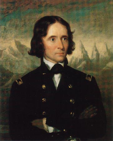
About the first of April, 1844, we were ready to start for home. We went up the valley of the San Joaquin, and crossed the Sierra Nevada and Coast Range by a beautiful low pass. We continued under Coast Range until we struck the Spanish trail, which we followed to the Mohave River, a small stream that rises in the Coast Range and is lost in the Great Basin. We continued down the Mohave and made an early camp at the point where the trail leaves the river. In the evening a Mexican man and a boy came to our camp. They informed us that they belong to a party of Mexicans from New Mexico. They were encamped with two other men and two women at some distance from the main party, herding horses. The man and boy were mounted, and the two men and women were in their camp, when he party of Indians charged on them for the purpose of running off their stock. They told the men and women to make their escape, and that they would guard the horses. They ran the animals off from the Indians and led them to a spring in the desert, about 30 miles from camp.
We started for the place they described, and found that the animals had been taken away by the Indians who had followed them. The Mexican asked Fremont to aid him to recover his animals. Fremont told his men that they might volunteer for the service if they wished, and that he would furnish horses for them to ride. Godey and myself volunteered, supposing that some of the other men would join us, but none did, and Godey and I and the Mexican took the trail of the missing animals. When we had gone 20 miles the Mexican’s horse gave out, and we sent him back. The night wasvery dark, and at times we had to dismount to feel for the trail. We perceived by the signs that the Indians had passed after sunset. We became much fatigued, and unsaddling our horses, we wrapped herself in the wet saddle blankets and laid down. The night was miserably cold and we could not make a fire for fear of its being seen. We arose very early and went down into a deep ravine where we made a small fire to warm ourselves.
John C. Fremont
As soon as it was light, we again took the trail, and at sunrise perceived the Indians encamped two miles ahead of us. They had killed five of the animals and were having a feast on them. Our horses could travel no farther, and we had them among the rocks and continued on afoot. We reach the camp unperceived, and crawled in among the horses. A young colt became frightened, and this alarmed the rest. The Indians at length noticed the commotion and sprang for their arms. Although they were about 30 in number, we decided to charge them. I fired, and shot one. Godey fired and missed, but reloaded and fired again, killing another. Only three shots at been fired into Indians were slain. The remainder now fled, and taking the two rifles I ascended ill to keep guard while Godey scalped the dead Indians. He scalped the one yet shot was proceeding towards the other one, who was behind some rocks. He was not dead yet, and as Godey approached he raised up and let fly a narrow, which passed through Godey’s shirt collar. Again he fell back and Godey finished him.
We rounded up the animals and drove them to the place where we had concealed our own. Here we changed horses and rode back to our camp with all of the animals, save the ones the Indians had killed for the feast. We then marched onto where the Mexicans had left the two men and women. We discovered the bodies of the men, horribly mutilated. The women, we suppose, were carried into captivity. But such was not the case, for a party traveling in our rear found their bodies very much mutilated and staked to the ground.
Resting Springs – where the massacre took place.
We continued our march without molestation till we reach the point where the trail leaves the Virgin River. There we intended to remain a day, our animals being much fatigued, the discovering a better situation, we moved our camp 80 miles farther on. Here one of our Canadians missed one of his mules, and knowing that it must have been left at the first camp, started back after it, without informing Fremont or any other party of his project. A few hours later he was missed. The members of the horse guard said he had gone to our last camp to look for his mule, and I was sent with three men to seek him. On reaching the camp we saw a pool of blood where he had fallen from his horse and knew that he was killed. We followed the trail of his animals to the point where it crossed the river that we could not find his body we can return to camp and informed Fremont of his death. In the morning he went with the party to seek the body, but it could not be found. He was a brave, noble-souled fellow, and I was saddened by his death. I had been in many an Indian fight with the Canadian, and I am confident that he if not was taken unawares, he killed one or two Indians before he fell. We now left the Virgin River, keeping to the Spanish trail, till we passed the Vega of Santa Clara, when we left the trail and struck out towards . . .
In days gone by, in the Turtle Mountains, a party of Mexican miners found a rich placer area and they reportedly sluiced off $30,000 before the summer heat dried up their water sources. for a clue back to the gold, they built a two room house with an arch in it. In 1883 two men (so the story goes, but we found records of three names for these (supposedly) two men: Jim Fish, Crocker, and Amsden) left Needles to explore the Turtle Mountains. A few weeks later only Amsden made his way to Goffs, more dead than alive, with his pockets full of gold. as soon as he recovered from his ordeal he returned to the east. A few years later Dick Colton of Goffs received a letter from him with a map and this message: “The mine is in the Turtle Mountains. The location is not far from a natural arch”. Since then many people have searched the area, but so far none have found the mine.
Leaving the headwaters of the Verde River in Arizona the party traveled to the Colorado River to the Mohave villages scattered along the east bank between what is now Topock and Bullhead City in Arizona. From there they traveled toward the middle of the desert, possibly on the route of either Fr. Garces in 1776, or further north on the trail taken by Jedediah Smith in 1826 and 1827, these converging at the mouth of the Mojave River east of Afton Canyon. It was two days before they found water after reaching the Mojave River. This may have placed them just east of today’s Barstow, California at a place that was known years later as Fish Ponds.
After four days travel we found water. Before we reached it, the pack mules were strung along the road for several miles. They smelled the water long before we had any hopes of finding any, it made all the best use of the strength left them after their severe sufferings to reach it as soon as they could. We remained here two days. It would have been impracticable to continue the march without giving the men and animals the rest which they so much required.
Colorado River at Moab across from Topock, Az.
After remaining in camp two days we resumed our expedition and for four days traveled over a country similar to that which we had traversed before our arrival at the last water. There was no water to be found during this time, and we suffered extremely on the account of it. On the fourth day we arrived on the Colorado of the West, below the great Canyon.
Mojave River fan
Our joy when we discovered the stream can better be imagined than described. We also had suffered greatly for want of food. We met a party of the Mojave Indians and purchase from them a mare, heavy with foal. The mare was killed and eaten by the party with great gusto; even the foal was devoured. We encamped on the banks of the Colorado three days, recruiting our animals and trading for provisions with the Indians, from home we procured a few beans and some corn. Then we took a southwestern course and in three days march struck the bed of the stream running northeast, which rises in the Coast Range and its lost in the sands of the great basin. We proceeded up the stream for six days, and two days after our arrival on it we found water. We then left the stream and traveled in a westerly direction, and in four days arrived at the of Mission San Gabriel.
San Gabriel Mission
At the mission there was one priest, 15 soldiers, and about 1000 Indians. They had about 80,000 head of stock, fine fields and vineyards, in fact, it was a paradise on earth. We remained one day at the mission, receiving good treatment from the inhabitants, and purchasing from them what deep we required. We had nothing but butcher knives to trade, and for four of these they would give us a beef.
Calico, like most of the Mojave Desert, is hot summer. An incident of the summer in the 1880s, while Calico was booming, indicates it was hot enough to send the devil scampering home to cool off.
Calico ghost town
The driver of the daily ice wagon was doing a grand business unloading his wares at three dollars a block, and no hagglers. That is, not until a newcomer, a man who had that day come to work in the mines, rushed out of the boarding house and gasped: “Give me a nickel’s worth of ice.”
The Iceman extended his hand, took the nickel, then stepped back to wait.
” Well?” the hot, tired, dust covered tenderfoot asked.
” Well?” the Iceman answered.
The new miner made no move. He stood there and looked blankly from the load of ice to its owner and back again. the Iceman opened his mouth once or twice as if to speak, then snapped his lips together.
” Well?” the newcomer repeated.
” Well yourself,” was the reply. “Maybe you don’t know it but ice is five cents a rub. If you don’t hurry, your rub is goin’ to be melted away!”
From “Loafing Along Death Valley Trails” by William Caruthers
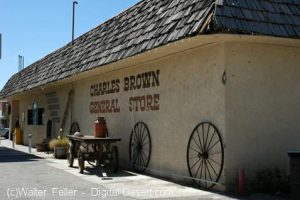
Charles Brown General Store – Shoshone, Ca.
The story of Charles Brown and the Shoshone store begins in Greenwater. In the transient hordes of people that poured into that town, there was one who had not come for quick, easy money. On his own since he was 11 when he had gone to work in a Georgia mine, he only wanted a job. And he got it. In the excited, loose-talking mob, he was conspicuous because he was silent, calm, and unhurried.
There were no law enforcement officers in Greenwater. The jail was 150 miles away. Every day was a field day for the toughs in the town. Better citizens decided to do something about it. They petitioned George Naylor, Inyo County Sheriff at Independence to appoint or send a deputy to keep some semblance of order.
Naylor sent over a badge and a note that said, “Pin it on some husky youngster, who is unmarried and unafraid and tell him to shoot first.”
The Citizens’ Committee met. ” I know a fellow who answers that description,” one of them said. ” Steady sort. Built like a panther. Comes from Georgia. Kind slow motion in till he is ready to spring. Name is Brown.”
The badge was pinned on Charles Brown.
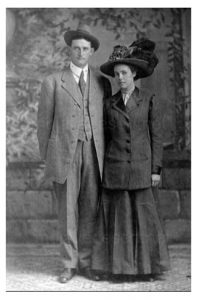
Charles & Stella Brown
Greenwater was a port of call for Death Valley Slim, a character of the Western deserts, who normally was a happy-go-lucky likable fellow. Periodically Slim would fill himself with desert “likker”, his belt with six guns and terrorized the town.
Shortly after Brown assumed the duties of his office, Slim sent word to the deputy that he was on his way to that place for a little frolic. ” Tell him, ” he coached the messenger, “Sheriffs rile me and he better take a vacation.”
After notifying the merchants and residents who promptly barricaded themselves indoors, the officer found shelter for himself in Beatty, Nevada.
So Slim only seen empty streets and barge shutters upon arrival. Since there was nothing to shoot at, he headed through Dead Mead Canyon for Greenwater. their he found the main street crowded to his liking and the saloons jammed. He made for the nearest, ordered a drink and, whipping out his gun, began to pop the bottles on the shelves. At first blast, patrons made a break for the exits. At the second, the doors and windows were smashed and when Slim holstered his gun, the place was a wreck.
Messengers were sent for Brown, who was at his cabin a mile away. Brown’s stuck a pistol in his pocket and went down. He found Slim in Waddell’s saloon, the town’s smartest. their Slim had refused to let the patrons leave with the bartenders cowed, the patrons cornered, Slim was amusing himself by shooting alternately at chandeliers, the feet of customers, and the plump breasts of the nude lady featured in the painting behind the bar. following Brown at a safe distance, was half of the population, keyed for the massacre.
Brown walked in and said “Hello Slim”. ” Fellows tell me you are hogging all the fun. Better let me have that gun, hadn’t you?” “Like hell,” Slim sneered, ” I’ll let you have it right through the guts.”
As he raised his gun for the kill, the panther sprung and the battle was on. they fought one over the bar room – standing up, laying down, rolling over – first one, then the other on top. Tables toppled, chairs crashed. For half an hour they battled savagely, finally rolling against the bar – both mauled and bloody. There, with his strong vice-like legs wrapped around Slim’s and in arm of steel gripping net and shoulder, Brown slipped irons over the bad man’s wrist. ” Get up,” Brown ordered as he stood aside, breathing hard.
Greenwater, Ca. ghost town site, Death Valley National Park
Slim rose, leaned against the bar. There was fight still in him and seeing a bottle in front of him, he had seized it with manacled hands, started to lift it.
” Slim,” Brown said calmly , ” if you lift that bottle, you’ll never lift another.”
The bad boy instinctively knew the look that foretells death and Slim’s fingers fell from the bottle.
Greenwater had no jail. Brown took him to his own cabin. Leaving the manacles on the prisoner, he took off his shoes and locked him in a closet. no man, drunk or sober, he reflected, would tackle barefoot the gravel street littered with thousands of broken liquor bottles. He went to bed.
Waking later, he discovered that Slim had vanished and with him, Brown’s size 12 shoes. Brown tried Slim’s shoes but couldn’t get his feet into them. There was nothing to do but follow barefoot.
He left a bloodstained trail, but at 2 AM he found Slim in a blacksmith shop, having the handcuffs removed. Brown retrieved his shoes and on the return trip, Slim went barefoot. After hog tying the prisoner, Brown chained him to the bed and went to sleep.
Thereafter, the bad boys scratched Greenwater off their calling list.
Slim attained fame with Pancho Villa down in Mexico, became a good citizen and later went east.
During the Spanish Colonial Period (1542-1821) in the American Southwest, the Spanish empire was competing for control over resources with the British, French, and Russian monarchies. They attempted to link colonies in the Spanish territories, later known as the New Mexico and California, by establishing trade routes to form a passageway across the entire Southwest desert region. The Old Spanish Trail was used commercially to link the towns that would later become Los Angeles, California, and Santa Fe, New Mexico, from 1829 until 1848. The abundant spring water available in the Las Vegas (meaning “the meadows” in Spanish) Valley made it an ideal resting point on the trail.
Old Mormon Fort – Las Vegas, Nevada
The presence of the valley springs also drew the Southern Paiute Indians, a nomadic people moving frequently during the year, who made the valley their winter homeland. They raised small crops near the springs in the valley, which provided water and food for the Indians inhabiting the area and later for travelers making their way across the desert.
The Las Vegas Valley would become an attractive place for other European-American settlers as well. One group of settlers looking for a new home was the Mormons–also known as the Church of Jesus Christ of Latter-day Saints–a religious sect organized by Joseph Smith in New York in 1830. Based on the Book of Mormon, which Smith said was revealed to him by heavenly messengers, this religious body felt called to restore the authentic church established by Jesus and his Apostles. The history of the Mormons is dramatic–filled with persecution, an exodus from the eastern part of the United States, and ultimately successful establishment of a thriving religious society in a desert. The Mormons formed in upstate New York, an area where the Second Great Awakening was most popular as the United States underwent a widespread flowering of religious sentiment and unprecedented expansion of church membership. The group was forced to move several times because of conflicts with residents in various places where they settled, including Ohio, Missouri, and Illinois. They were accused of blasphemy and inciting slave insurrections. After Smith was killed by an angry mob in Illinois in 1844, it became necessary for the Mormons to find a new home once again.
A new leader emerged to guide the Mormons to a new Zion at the Great Salt Lake. Under the direction of Brigham Young, they began an arduous journey West to what would become Utah, where they arrived in July of 1847. In 1848, after the war with Mexico, the United States acquired the majority of what now constitutes the American Southwest. The Mormons petitioned Congress to become the State of Deseret, a word from the Book of Mormon signifying honeybee which was considered an industrious creature, but they were only allowed territorial status. Congress established the Territory of Utah, named for a local Indian tribe, and President Fillmore appointed Brigham Young governor in 1851. Young also became superintendent of Indian affairs. He oversaw the building of Salt Lake City and hundreds of other southwestern communities.
In the middle of the 19th century, the idea of “Manifest Destiny”–a phrase used to explain continental expansion by the U.S.–was embraced by many American people, including the Mormons. They began an industrious campaign to colonize Utah and beyond, establishing hundreds of settlements throughout the West and Southwest. As part of this process, Brigham Young called on volunteers to create a Las Vegas Mission, which would be strategically located alongside the Mormon Road (a portion of the Old Spanish Trail between New Mexico and California), halfway between the Mormon settlements of southern Utah and the San Bernardino Mission in southern California. There were eventually 96 settlements that included Lehi, Provo, Payson, Nephi, Fillmore, Beaver, Parowan and Cedar City. Meanwhile, the discovery of gold in California in 1848 made southern Nevada a corridor for westward emigrants and gold seekers. A gold seeker wrote in his diary on November 21, 1849 about stopping at the Las Vegas creek. Offering the only reliable supply of water for a 55-mile stretch along the Mormon Road, the Las Vegas Valley’s springs were important for watering the mules, horses and oxen of travelers crossing the region’s harsh desert environment. With the opening of the San Bernardino settlement in 1851, there was an additional need for a way station at the Las Vegas springs to provide supplies and rest. The mission the Mormons established as part of the Church’s westward expansion out of Utah became the first non-native settlement in the area, and the Mormons hoped to bring the American Indians into their flock. Although the Mormons occupied the site only from 1855 to 1858, it affected the development of what was to become southern Nevada.
from — The Old Mormon Fort: Birthplace of Las Vegas, Nevada — National Park Service
From the parking lot of the Victor Valley Jr. High School Gym you will have an unobstructed view of the Victorville “V”.
Notes
In 1930 the Victor Valley High School site was where Victor Valley Jr. High is currently located. The Victorville “V” was placed on the side of the hill as a landmark for the high school. Keith Gunn, then high school football coach and shop teacher, later to become principal, spearheaded the project of the “V”. Southwestern Portland Cement Co. donated the cement and the students of the high school football team were responsible for the actual installation.
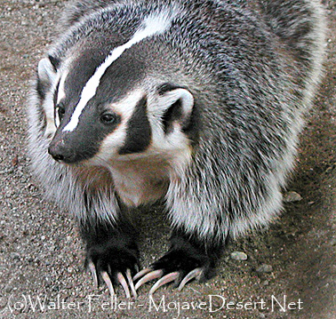
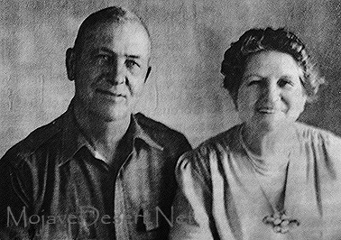
Much the same as for anywhere and anyone else, times were both good and not so good. Once, after a forty day stretch of having nothing but jackrabbit to eat, their pet badger found its way to the dinner plate. The Mitchell’s felt terrible about it, but what has to be done has to be done. From the experience, Jack came up with the following technique for preparing badger:
First remove the head and hide and probably the insides. Mix a generous amount of dish soap, a gallon bottle of PineSol, and a goodly quantity of Alka Seltzer together in a large wash tub. Don’t forget the Alka Seltzer because if you happen to taste the meat, or get some in you, the seltzer will fizz and the animal will think a rattlesnake crawled into its hole and it’ll come right out of you possibly leaving you alive. Soak the badger in it for six weeks. This will give the meat a shiny, silky texture when you take it out of the oven and gives the chemicals a chance to thoroughly penetrate the meat and saturate it with its subtle and aromatic chemicals.
Jack and Ida Mitchell
Your badger is now ready for the oven. Next, find an old piece of concrete that will fit in the oven. Strap the badger to the concrete, surround with overly-ripe limburger cheese, then salt and pepper liberally. Be sure to tie the badger down tight to the concrete as you don’t want it to escape-it may still be able to. Place the whole thing in the oven that has been preheated to 500 degrees. Next, set the temperature to 2800 degrees and call in a fire alarm. After the fire is put out, open all the doors and windows to get some fresh air in the room, pry open the molten oven door, scrape the badger and cheese off the slab, throw them in the garbage and eat the concrete. I recommend serving with a sledge hammer and suggest a boiling pot of very strong coffee to wash it down. You’ll need it.
Wagon wheel furrows cut deep in the sand, winding through desolate desert land, on through arroyos, climbing a rise to snow-covered mountains that reach to the skies; ruts that the elements tried to erase from the deserts redoubtable face, but fate has preserved, through all of these years, the trail of the wagon train pioneers.
We follow their route in a multi-wheel drive and marvel that anyone could survive. Through famines, and droughts, and blizzards and rain on a rumbling ox-drawn wagon train, and eke out a living from off of a land of solitude, emptiness, cactus and sand; Did they vision rainbows way over there where we find a cauldron and the smog laden air?
What will the future historians find when they search for the trails we leave behind? Will our many-lane highway be plain to see, that leads toward that “Great Society?” Or maybe they’ll excavate someday, through atomic ashes to our freeway, and wonder how anyone could survive, on a careening, rumbling, four-wheel-drive.
Mohave III – Scrapbooks of History, Mohahve Historical Society, 1966
Proceed north on 6th Street (cross “D” street) to “E” Street and turn left. A “point of interest” sign marks the site of the jail which is currently being restored.
Notes
In 1907 the first jail “opened for business”. Constable Ed Dolch was instrumental in getting the structure built. Lack of running water or heat, plus the the type of punishment (helping to drain the nearby swamp), were deterrents to criminal activities. Originally erected on “E” Street.
Mrs. Kemper Campbell, with her husband and their law partner, Mr. Sorenson, acquired the Verde Ranch in 1924. Mrs. Campbell, now 76 years of age, recalls that the original Verde ranch was approximately 4000 acres. The Campbells retained the north portion of 1900 acres, while Mr. Sorenson retained the south portion. Part of the Kalin ranch, from the south portion along Bear Valley Road, is now being developed for the new Victor Valley College.
Verde/Kemper Campbell Ranch
Mrs. Campbell describes the red House is consisting of nine rooms and in good repair. The “red house” was built in 1870 by John Brown Sr. and was used by the Mormons as a hotel and stopover. It was a meeting place of the pioneers on their journeys south to the San Bernardino Valley. In 1867, John Brown homesteaded the Verde Rancho, which became the first major ranch of the Mojave River Valley. Horse and cattle raising and production of alfalfa have been the major uses of the ranch by a succession of owners: the Coles, Sterlings and Greers before the Campbells and Mr. Sorenson became owners. The Campbells operated their portion as a working ranch. In the 1930s they added attractions for guests, and for many years it was well known as the “North Verde.” after the death of their oldest son during World War II the name was changed to “Kemper Campbell Jr. Ranch” in his memory.
Adapted from Mohahve I – Scrapbooks of History, page 93 – Mohahve Historical Society
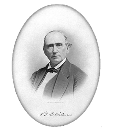
in the summer of 1845, Benjamin D Wilson, own part of the interest in the Jurupa Rancho, site of the present city of Riverside, led a troop of Calvary in search of cattle rustlers.
Setting out from San Bernardino Valley, he divided his command. Most of the men he sent through Cajon Pass, keeping only 22 Mexican troopers with him to follow a trail across the mountains. Two days later, Wilson and his men reached the lake where they sighted scores of grizzly bears.
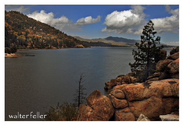
Big Bear Lake
Most of the soldiers had been vaqueros. They formed in pairs and drew reatas, each pair attacking a bear. One looped a rope around bear’s neck; his companion roped same bear by a hind foot. Then the men drew apart to stretch the rope taut and hold the bear a prisoner. They bagged and skinned eleven bears, stretched their hides and continued across the mountains to join the rest of the command on the desert at Rancho Las Flores, on the Mojave River.
Here the reunited party engaged Indians in a fight, after which Wilson and his 22 vaquero-troopers returned home by the way of the lake. They again found the place overrun with bears, and the same 22 soldiers brought in eleven more bears– enough to give them a bear rug apiece as a trophy. It was then that Wilson gave the name of Bear Lake to the little body of water.
Years later the name was changed to Baldwin Lake. The name survives, however, in Big Bear Lake which was created in the site of the Talmadge Ranch in 1884 when a dam was built to provide a constant water supply for the Redlands District.
–
adapted from ~ Pioneer Tales of San Bernardino County – WPA – 1940.
Johnny Lang set out one day in 1894 to search for a lost horse. He ran smack into a band of rustlers and found a fortune in gold.
Johnny was plodding over the little San Bernardino Mountains, in that area known today as Joshua Tree National Monument, Where masses of rock form fort-like walls around hidden valleys and grass meadows. Here it was that the rustlers pastured their stolen stock. They ran choice cattle and horses ranches in Arizona, into the little San Bernardino’s ( by easy stages), and from there they spread through Southern California, selling their contraband herds.
The first thing Johnny knew one of the rustlers lookouts who drew a gun and threatened him. ” You ain’t lost no horse,” the gunman said. “Git going!”
Johnny made his way back down the mountain and return to the camp. There he met another prospector, a stranger, who pointed out a nearby hill as a likely spot to dig for gold. Johnny took his advice. He found a rich outcropping of ore and staked out a claim which he called the Lost Horse Mine.
Bill & Willis Keys burying Johnny Lang
News of the strike brought on a gold rush– and that was the end of the last great band of organized rustlers entrenched in California. The minor sworn to the hills and valleys and drove the rustlers from their hideouts. Johnny Lang made fortunes during his lifetime and never saved up any. One day in 1928 he was found dead. He died with his boots on, still searching for gold in the wilderness of rock.
adapted from ~ Pioneer Tales of San Bernardino County – WPA – 1940.
The characteristic account of the hazards of traveling through the Mojave during pioneer days appears in the journal of General John Charles Fremont. Leading a party of topographical engineers, with the famous Kit Carson and Alex Godey as scouts, Fremont was on the last leg of an exploration trip through Oregon and California, and was headed for Salt Lake City when he called camp at the lagoons 8 miles below Yermo for the purpose of killing and jerking enough beef for the long “jornada” to the next waterhole.
Here, on the afternoon of April 24, 1844, Fremont was surprised by the sudden appearance of two Mexicans, one a man, Andreas Fuentes, the other an 11-year-old boy named Pablo Hernandez. They were members of an advance party of six men and women who had left Los Angeles well ahead of a large caravan, in order that they might travel leisurely with their head of 30 horses. They had reached Agua Archilette (now Resting Springs) , where they decided to remain until the caravan overtook them. While camped here, they were visited by several seemingly friendly Indians. A few days after this they were surprised to see approaching them a large number of Indians, estimated to be about 100.
Agua de Archilette (Resting Springs)
The commander of the Mexican party shouted to Fuentes and Pablo, who were on guard duty, to drive the horses to their former water hole. The guards were mounted according to custom and managed to stampede the horses through the Indian lines despite a volley of arrows. Knowing they would be pursued, the man and boy drove the horses about 60 miles, halting only to change mounts. When they reached Agua de Tomaso (now Bitter Springs) they left the horses there and pressed on, hoping to meet the oncoming caravan. Exhausted, the two were overjoyed to find the Fremont party.
Agua de Tomosa (Bitter Springs)
The Fremont cavalcade broke camp immediately, left the river and, turning north, followed the old Spanish trail 25 miles to Agua de Tomaso. Here they found traces of recent origin that showed the Indians had captured the horses and run off with them. Carson and Godey, accompanied by Fuentes, decided to follow the marauders. That evening, Fuentes returned alone, his horse having given out.
The scouts had been taken about 30 hours. They estimated their trip had taken them about 100 miles. At nightfall of the first day they had entered the mountains. Bright moonlight made the pursuit easy for a time, but when they entered a defile, it became necessary to dismount and feel for the trail with their hands. At midnight they lay down to sleep.
Cold as it was, they dared not to make a fire and till morning when in a little ravine, they kindled a tiny blaze to warm themselves before starting on.
Christopher “Kit” Carson
At daylight they continued their pursuit and about sunrise ran across a few of the missing horses. Concealing their exhausted mounts behind a pile of rocks, they crept toward the crest of a nearby hill, from which they could look down on four lodges and about 30 Indians were gorging themselves on horse meat.
The cautious movements of the scouts disturbed a horse grazing nearby, which snorted, giving warning of their presence to the feasting Indians. The scouts charged, shouting as they went. Carson downed in the Indian with his first shot. Godey shot twice and hit another. Godey received an arrow through his shirt collar. The rest of the Indians fled, no doubt believing the two men were the advance of a large party.
Carson stood guard while Godey dashed down to scalp the two prostrate figures. As he stripped the scalp from one of them, the Indian regained consciousness and screamed. An old squaw, ascending a nearby hill, turned, hurled a handful of gravel down on Godey, and screeched maledictions. Godey mercifully killed the man. Then the scouts returned to the herd and drove it off without interference.
John C. Fremont
The scouts’ story told, Fremont ordered camp broken. The party proceeded north across the open plain. Two days later, Fremont came across the bodies of two men, Hernandez, father of Pablo, and another member of the Mexican advance party. Both had been mutilated. Later the bodies of the two women who completed the advance party were discovered, also murdered and mutilated.
adapted from ~ Pioneer Tales of San Bernardino County – WPA – 1940.
In 1840, raiders under Peg-leg Smithand Wakara, an Indian renegade, made a simultaneous attack against a number of ranches in Southern California and drove off hundreds of horses. Some of these horses came from as far north as San Luis Obispo, but all were run south and into the Mojave Desert through the Cajon Pass.
Horse Thief Springs – Kingston Range
When Peg-leg was asked how many horses had been stolen, he replied, “Only about 3,000. The Spaniards followed us and got half of what we started away with, damn them.” During that wholesale raid, Wakara, alone, is believed to have led about 1,000 tame horses from the mission corral at San Luis Obispo.
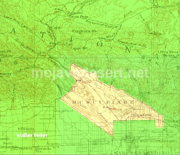
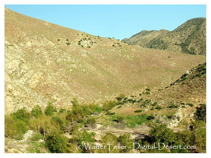
In 1843, Michael White obtained a grant to the El Cajon de Muscupiabe Rancho in Cajon Canyon, for the purpose of guarding the pass against the Indian raiders. It was the practice of the marauders to slip through the pass in the San Bernardino Mountains, and, under cover of darkness, to rob and pillage. Their constant raiding depleted the Californian’s herds.
In the early fall of 1845, Governor Pio Pico sent against the plundering Indians a force of 80 well-armed men under the command of Benjamin D Wilson. Wilson was a native of Tennessee and had been a trapper in New Mexico when he joined the Workman party which entered San Bernardino County in 1841. In 1843 he purchased one-half interest in the Jurupa Grant with Juan Bandini.
Following the instructions of the governor, Wilson planned and outfitted its expeditionary force. A pack train and 58 soldiers passed through the Cajon, and Wilson, with 28 Californians, crossed the mountains. From Bear Valley, the Wilson party followed the East Fork of the Mojave River down to the Mojave desert floor. There they joined the other division. For several days the expedition marched northward along the Mojave River. Wilson, riding a mule, was usually two or 3 miles in advance, looking for Indian signs.
On the fourth or fifth day, Wilson saw four Indians coming toward him along the trail. Certain they had not seen him, he turned his mule into the river bed and kept under cover until he judged he was opposite them. When he climbed the bank he called in the savages responded in a friendly manner.
It had been Wilson’s intention to take the Indians prisoner in order to obtain some much-needed information, but one of the four was a renegade Indian for all Southern California had been looking– at the notorious Joaquin. Joaquin had been trained as a page by the Catholic Church at the San Gabriel Mission, but a career of crime brought him the customary reward: a branded lip and a cropped ear.
Mission San Gabriel
Wilson commenced a conversation in Spanish, and the Indians to them to be nothing more than a traveler until his force came into view. Joaquin, realizing that Wilson was the vanguard of this group, jerked an arrow from his quiver and strung his bow. Wilson fired from the hip at the same time Joaquin loosed his arrow. The Indian shaft struck Wilson in the right shoulder; the white man’s bullet pierced Joaquin’s breast area the force of the arrow caused Wilson to drop his gun, but the shot had brought Joaquin to the ground where he lay cursing the white race.
The other three Indians made off across the desert. Wilson ordered his soldiers to take their life. The Indians resisted and were killed. Joaquin watching the slaying of his kinsman continued to pour profanity on Wilson and his kind until a soldier put him to death.
Don Benito Wilson – 1870
Upon examination of his wound, Wilson found that he had been struck by an arrow made poisonous by putrid meat blood. The Comanche Indian, Lorenzo Trujillo, who had accompanied Wilson from New Mexico suck the blood from the extremely painful wound. Although the swelling began to reduce, Wilson was unable to travel, so he kept five men with him and sent the remainder down the river to find the Indian camp.
After several days, his command returned to report that they had struck a fresh Indian trail about 10 leagues below Wilson’s camp. Following the trail up a rocky mountain, they discovered Indians hidden among the rocks. The Californians made an attack but were obliged to retreat with several badly wounded men, leaving the Indians in command of their natural fortress. Wilson’s wound now healed, this first major battle between San Bernardino settlers and Mojave marauders pronounced a draw, and the punitive expedition withdrew to return the wounded man home.
adapted from ~ Pioneer Tales of San Bernardino County – WPA – 1940.
Holcomb Valley, north of Big Bear Lake, was the scene in the biggest gold rush in Southern California history. Actually there were at least three different boom periods in the valley-the early 1860s, the mid-1870s and the 1890s. There has also been considerable mining activity here in the 20th century–including a large mine still operating.
Although the area is named for the leading publicist, William F Holcomb, who found a gold vein in 1861, Mormon miners from San Bernardino worked claims in the area at least six years before that. Their activities were well reported in the Los Angeles Star of the 1850s. They did not want a large rush of people to the area, and they got their way, until Holcomb’s loud announcements of his discovery.
The main route to the valley was by way of Cajon Pass and across future Victor Valley on what was known as the Van Dusen Road. Thus there was a close tie of the mining area to the Mojave River community. Several early Victor area settlers, including Samuel Rogers and John J Atkinson, were deeply involved in Holcomb Valley before and during their time in the high desert.
Another tie of the Victor Valley to the Holcomb Valley is that the Hitchcock range summer range was at an extensive mountain meadow ranch in Holcomb Valley and the winter range, in Apple Valley. The mountain ranch is still intact in the Boy Scout camp-reservation. They would be open to historical Society assistance preserving the facility. Holcomb Valley is one of the best artifacts in place of the regions mining history. Those who visit the area never forget it
~ Leo Lyman
The Mohahve Muse – Volume 3, Issue 7 – September 2000
Mohahve Historical Society
Mining History of Cushenbury Canyon
& its Impact on the Victor Valley
Mitsubishi Cement Corp.
The gold discovery in Holcomb Valley in 1860 brought a rush of fortune seekers to the Victor Valley including some foreign interests. The English family of Del Mar’s had a significant impact on Cushenbury Canyon. Holcomb Valley miners affected California history by participating in their own Civil War actions and may have left treasure in their wake.
World War II ended the golden era and Cushenbury Canyon but initiated another mineral rush. The postwar California population boom brought about the industrial minerals revolution fueled by the construction industry.
Kaiser Cement built a cement plant and Cushenbury Canyon as an indirect result of the decision by an American General during World War II. The facility was modernized in 1982 and Mitsubishi Cement Corp. purchased the plant 1988. Today Mitsubishi Cement Corporation Cushenbury Plant is one of the leading industries in the Victor Valley.
The industrial minerals boom has a direct impact on everyone’s lives here in the US. The industrial minerals mined in the Victor Valley fuel the economy in California. San Bernardino County provides largest source mineral commodities in the US. ” If it can’t be grown, it has to be mined!” the mining industry provides the “stuff” to make the “things” we need to continue our lifestyle.
The Mohahve Muse – Volume 4, Issue 3 – March 2001 – Mohahve Historical Society
Leo Lyman – President
Blond-haired, whiskered veteran prospector Richard C. Jacobs and partner Bob Stewart were grubstaked by W. L. Kennedy, a Kernville merchant. Most grubstakes failed, but these two men wandered over to Panamint Valley, then up the steep 6,000-foot climb of Surprise Canyon and found several types of silver ore exposed by erosion. They made four claims, formed Panamint Mining District, and elected Bob Stewart as recorder. Samples shown to Kennedy assayed from $125 to $3,000 per ton. By April 1873, there were 80 to 90 claims. The Panamint mining started fairly normally until the search for investors brought in wealthy and influential men: two Nevada U. S. Senators, John P. Jones and William M. Stewart, and ex-49er Trenor W. Park, a New York Wall Street investor, formerly a San Francisco lawyer and current director of Pacific Mail Steamship Company and president of the Panama Railroad that linked the two oceans. Experienced in mining and investing, these successful men encouraged others to rush for quick potential riches.
Panamint Fever had started.
Miners from 29 Palms, Ivanpah, Arizona, Nevada, and northern California came to Panamint Valley and made the horrid trip up Surprise Canyon to the Panamint Mountains on a road that is still more of a dry waterfall than a road. Miners found a small booming city with sounds of hammering, dragging, and building all over, and sounds on higher hills of dynamite exploding. Anybody who wanted to work had a job at $4 per day, board $7 per week—not bad wages for those days. In March 1874 there were over 700 men who already staked about 150 claims and were still prospecting to find that great silver lode like at Virginia City. Men rented a room or a space on the ground at “Hotel de Bum,” a huge tent. Most slept outside in blankets looking at the stars.
Wagons unloaded supplies at the bottom of Surprise Canyon and pack mules made it up the waterfall road, unloading their gear to tent stores, potential wooden and rock buildings, or to mines further up the hill. Jacobs hired Chinese laborers to cut down the steep grade over the Slate Range so his 10-stamp mill could be brought easily to Surprise Canyon. Owens Valley businessman Bart McGee sculptured a road up Surprise Canyon, thereby enabling wagons to use the waterfall road (where the grade was 500 feet to the mile). Seven stages a week arrived at the new city by the end of 1874.
Panamint City developed almost a mile of businesses for city amenities. According to mining historian Remi Nadeau, the city had a dozen saloons, a water company, six general stores, three bakeries and restaurants, a livery stable, boot shop, meat market, three barbershops, a newspaper called Panamint News, the Bank of Panamint, and another important town amenity: a log cabin brewery. When Martha Camp, a buxom lady from Nevada, brought her ladies to town, the night life in Panamint became livelier—it became a real city!
As usual, gamblers, criminals, gun fighters, and assuredly con-artists, climbed the hill to Panamint. The town soon needed a jail. As a result of a gambling dispute, a shootout in a saloon in which Kirby, a man from Pioche, shot Bill Norton in the leg and ran away when Norton fired back. The only official in town was town recorder W. C. Smith who discovered Kirby planned to waylay Norton. Smith got the drop on Kirby and suggested he leave town right away. The town later elected Smith Justice of the Peace. Jim Bruce and Edward Barstow, a night watchman of the town, had an argument in Camp’s house. Barstow, drinking too much, left the business but returned later after he sobered a bit and found Bruce in Martha’s bed and shot it out with Bruce. Barstow died. The town needed a cemetery.
A few years later the boom and fever ended. But the effects on the Mojave Desert was great. San Bernardino County appointed Oro Grande’s Aaron Lane as Superintendent of desert roads, namely the Road to Panamint from the Mojave River to the Inyo County line. Desert “Stations”—ranches like gas stations and motels today—were built and profited, especially with freight from San Bernardino over the Cajon Pass. For example, lumber mills in the San Bernardino Mountains supplied much of Panamint’s lumber. Berdoo merchants out- hustled L.A. businessmen. Despite Panamint’s decline in the late ’70s, mining increased in the Mojave Desert, especially with Barstow’s Waterman Mine and the wonderful Calico Hills discoveries. The Mojave Desert became settled by the end of the 1880s.
“It looked a lot straighter on the map.” – Anonymous
The Mormon Road going south across the Oro Grande Wash would come up and head straight into the Joshua trees and juniper woodland. The slope was fair, the ground hard and the trail reasonably straight. There were variations, though. To the eyes of one, one way around a bush may look easier than it does to another. Trails evolve. If one branch is significantly better than another, that branch becomes wider and more popular. These branches and shortcuts may join together later. These variations due to mankind and weather begin a process I have heard to be called, “braiding.” It is quite possible for the main alignment, the busiest, the center-most version in the corridor to remain in use providing its continued existence to this very day.
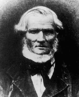
Captain Jefferson Hunt
b. January 20, 1803
d. May 11, 1879
Jefferson Hunt – LDS photo.
… Jefferson Hunt had rejoined his family at Salt Lake Valley after the close of his military service, and he was called by President Young in November of 1847 to return to California to purchase seed, livestock and supplies for the people of the Church. There were eighteen in the company, including his sons, Gilbert, John and Peter Nease. On this trip they suffered greatly for food, having to subsist for some days upon the flesh of their work mules, but through all such ordeals, Great Grandfather rose to the occasion and manifested the great strength of body and mind necessary for a wise father and leader of men to possess. The little boys, John and Peter, suffered greatly on this trip, being only 14 years old and not accustomed to starving. They returned to Salt Lake in May, 1848, bringing horses, mules, cattle, seed and provisions. During the following two or three years he acted as pilot and guide to companies of gold seekers going to California.
In 1851, Jefferson Hunt was called by the leaders of the Church to go with Apostle Amasa Lyman and Charles C. Rich to establish a Mormon colony in San Bernardino, California.
In the years that followed, he served his church as a member of the High Council of San Bernardino. He served his church and the State of California as a member of the legislature for six years, and he was appointed with a delegation of California lawmakers to go on a special mission to Washington D.C. Their trip from California to Independence Missouri was all accomplished on horseback.
With the coming of Johnston’s Army to Utah in 1857, Jefferson Hunt responded to the call of Brigham Young, and with the other loyal members of the church they left their homes in San Bernardino and came to Utah.
His service to the State of California was recognized in tribute paid to him by the California historian Ingersol: “Captain Hunt was a man of strong character, deeply religious by nature, he believed with his heart in the divine revelations of the Mormon Doctrines. Energetic, clear sighted and indomitable in will, he was especially fitted for the leadership, which he always acquired in whatever position he was placed. Generous to a fault, his home was open to his less fortunate brethren, and he gave a helping hand to many a needy man, saint and gentile alike for he was above petty distinction. He deserves a large place in the memory of the citizens of San Bernardino for he filled a large place in the early and vital events in the history of the town and country. While he served as legislator he introduced the bill to divide Los Angeles County from San Bernardino County, and has been known since as the Father of San Bernardino County.”
~
Adapted from a copy of an address given at the dedication of a monument erected at the grave of Captain Jefferson Hunt in 1950. The speaker was his great grandson, Jesse A Udall.
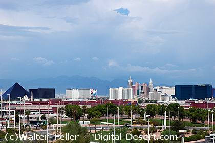
During the Spanish Colonial Period (1542-1821) in the American Southwest, the Spanish empire was competing for control over resources with the British, French, and Russian monarchies. They attempted to link colonies in the Spanish territories, later known as the New Mexico and California, by establishing trade routes to form a passageway across the entire Southwest desert region. The Old Spanish Trail was used commercially to link the towns that would later become Los Angeles, California, and Santa Fe, New Mexico, from 1829 until 1848. The abundant spring water available in the Las Vegas (meaning “the meadows” in Spanish) Valley made it an ideal resting point on the trail.
Las Vegas
The presence of the valley springs also drew the Southern Paiute Indians, a nomadic people moving frequently during the year, who made the valley their winter homeland. They raised small crops near the springs in the valley, which provided water and food for the Indians inhabiting the area and later for travelers making their way across the desert.
The Las Vegas Valley would become an attractive place for other European-American settlers as well. One group of settlers looking for a new home was the Mormons–also known as the Church of Jesus Christ of Latter-day Saints–a religious sect organized by Joseph Smith in New York in 1830. Based on the Book of Mormon, which Smith said was revealed to him by heavenly messengers, this religious body felt called to restore the authentic church established by Jesus and his Apostles. The history of the Mormons is dramatic–filled with persecution, an exodus from the eastern part of the United States, and ultimately successful establishment of a thriving religious society in a desert. The Mormons formed in upstate New York, an area where the Second Great Awakening was most popular as the United States underwent a widespread flowering of religious sentiment and unprecedented expansion of church membership. The group was forced to move several times because of conflicts with residents in various places where they settled, including Ohio, Missouri, and Illinois. They were accused of blasphemy and inciting slave insurrections. After Smith was killed by an angry mob in Illinois in 1844, it became necessary for the Mormons to find a new home once again.
A new leader emerged to guide the Mormons to a new Zion at the Great Salt Lake. Under the direction of Brigham Young, they began an arduous journey West to what would become Utah, where they arrived in July of 1847. In 1848, after the war with Mexico, the United States acquired the majority of what now constitutes the American Southwest. The Mormons petitioned Congress to become the State of Deseret, a word from the Book of Mormon signifying honeybee which was considered an industrious creature, but they were only allowed territorial status. Congress established the Territory of Utah, named for a local Indian tribe, and President Fillmore appointed Brigham Young governor in 1851. Young also became superintendent of Indian affairs. He oversaw the building of Salt Lake City and hundreds of other southwestern communities.
In the middle of the 19th century, the idea of “Manifest Destiny”–a phrase used to explain continental expansion by the U.S.–was embraced by many American people, including the Mormons. They began an industrious campaign to colonize Utah and beyond, establishing hundreds of settlements throughout the West and Southwest. As part of this process, Brigham Young called on volunteers to create a Las Vegas Mission, which would be strategically located alongside the Mormon Road (a portion of the Old Spanish Trail between New Mexico and California), halfway between the Mormon settlements of southern Utah and the San Bernardino Mission in southern California. There were eventually 96 settlements that included Lehi, Provo, Payson, Nephi, Fillmore, Beaver, Parowan and Cedar City. Meanwhile, the discovery of gold in California in 1848 made southern Nevada a corridor for westward emigrants and gold seekers. A gold seeker wrote in his diary on November 21, 1849 about stopping at the Las Vegas creek. Offering the only reliable supply of water for a 55-mile stretch along the Mormon Road, the Las Vegas Valley’s springs were important for watering the mules, horses and oxen of travelers crossing the region’s harsh desert environment. With the opening of the San Bernardino settlement in 1851, there was an additional need for a way station at the Las Vegas springs to provide supplies and rest. The mission the Mormons established as part of the Church’s westward expansion out of Utah became the first non-native settlement in the area, and the Mormons hoped to bring the American Indians into their flock. Although the Mormons occupied the site only from 1855 to 1858, it affected the development of what was to become southern Nevada.
There is a book titled “Trails across the Mojave” that describes a fork in the Old Spanish Trail that splits off to John Brown’s toll road on the left and the Mormon Hogback and Sanford’s Pass to the southwest. Now the photo showing the fork located according to the directions provided most likely has no resemblance to what the original trail looked like if it were indeed at this particular point. I would say this fork is basically the same alignment in the same location as the trail was 150 years ago. The left goes to Cajon Summit while the right leads to Phelan to descend into the West Cajon Valley.
There is another important location to be remembered, it is the “Division of Trails” that goes over Cajon Pass. The word “Cajon” is Spanish and means “box”. The steep sides of the formidable mountain pass made the name appropriate. The rigors of El Cajon must be faced to arrive in San Bernardino Valley. The high Sierra Mountains were the last barrier to the weary travelers.
Here the trails divided. The left fork was the way used by the pack-trains of the Spanish traders and was called the Old Spanish Road. The other road was chosen by the Mormons for they had wagons which could not be pulled up or down the narrow canyon which the Spanish had followed. So, the Mormons made a bend westward to the right to avoid the higher portion of the mountains. This division of trails is today a a few hundred yards to the east of Highway 395 at the crossroad of Duncan Road.
The Spanish trail turned back to the left and slowly climbed the summit, entering the edge of Horse Thief Canyon. From there they traveled down grade about 6 miles until reaching Crowder Canyon (earlier called Coyote Canyon), then from Cajon junction the road went south which is located today on the present Highway 66. This section in the 1860s and 1870s was known as John Brown’s toll road.
Trails across the Mojave – Grace Jackson, Lucille Matson – 1970
One day a wagon train rolled in off the desert to San Bernardino. On this wagon train there were four sick and hungry Paiute Indian boys.
Each one of these boys was placed with separate families in San Bernardino, and each one of the boys, living in a good Mormon home, got better.
One boy went rabbit hunting with his foster brother. There they ran into the Thomas brothers who were also out hunting. One brother got into an argument with the Indian boy. They get louder and louder then the Thomas boy raised and aimed his pistol at the Indian and the Indian immediately raised his rifle and shot Thomas. He fell over dead.
Obviously, it was self-defense and no matter how they looked at it at trial it came out self defense. The Indian was acquitted and went free.
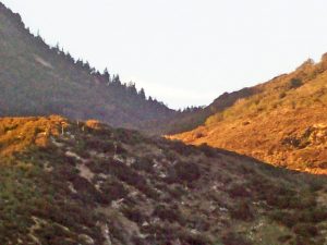
Sawpit Canyon
Life went on and things seemed as if things were forgotten and when it came time for the Indian boys to go home, an escort was provided for them. The escort was made up of one of the Thomas’ and several of his friends.
The party left San Bernardino and rather than going up the Cajon Pass, they took the old trail up Devil’s Canyon to the ridge then dropped down into Sawpit Canyon. The area was heavily forested and the young Paiute that had killed the Thomas boy figured out what was going on and slipped into the woods escaping.
Summit Valley
The remaining three boys were brought down into what is now the Las Flores Ranch area and summarily murdered. Then they were decapitated and their heads placed on the top of long poles.
Not much was ever mentioned of the incident afterwards most, likely because the boys killed were Indian.
A few years later a caretaker on the property found two of the skulls. He took them and nailed one to each of the gate posts at the entry to the ranch. Being the braggart that he was, he would tell the story of the Indian skulls nailed to the gate and if an Indian wanted to know what that story was, they were welcome to come and an he would happily show them.
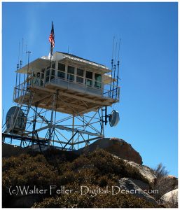
Keller Peak Lookout, a historic fire lookout tower, was built in 1926 and is the oldest fire tower still standing in the San Bernardino National Forest.
The lookout is little changed from its 1926 appearance, and it represents one of very few fire towers in California dating from before the Great Depression.
Keller Peak is still used during the high fire hazard months, and volunteer lookouts are on-duty between May and November.
Huntington’s Station was the first trading post in the area, and although Heber Huntington only owned it from 1873 to 1878, it remained known as Huntington’s Station until the the railroad came through and renamed it Victor. The river crossing with a few modern exceptions as the Narrows Bridge, Rainbow Bridge, and the cement plant looks much the same today as it did in 1872 when Mecham built what has become Stoddard Wells Road.
“During his years at the upper crossing, Captain Lane, as Aaron was known throughout much of his life in California, had ample opportunity to discover where the richest farmlands lie along the Mojave River.”


 — Keller Peak Historic Fire Lookout Tower —