Tag: california history

  • From Ancient Oasis to Desert Stage Stop

    Little Lake, California:

    Little Lake is a small, spring-fed lake tucked between volcanic cliffs and a red cinder cone along California’s Highway 395. To most modern travelers, it’s just a quick blur on the drive north through the high desert. But beneath its quiet surface lies a deep and layered past—one shaped by ancient peoples, rugged prospectors, and enterprising families who turned this desert watering hole into a hub of life and legend.

    A Desert Legacy Thousands of Years Old

    Long before roads or railroads existed, Little Lake served as a seasonal home to Native American groups that lived and moved throughout the Mojave and Great Basin deserts. Archaeological findings suggest that humans camped here as far back as 10,000 years ago, drawn to the dependable water and abundant resources.

    Rock art etched into the black basalt cliffs tells part of this story. Petroglyphs depict figures with atlatls, mountain sheep, and human forms, suggesting the spiritual and practical aspects of these early people’s lives. Over the centuries, different cultural traditions passed through, but one of the most important was the Pinto Culture. This group lived in the region several thousand years ago and left behind signature dart points and evidence of circular house foundations—some of the oldest in California.

    Among the most intriguing discoveries is the so-called “Pinto Man,” a human burial found in a shallow grave near the lake, buried with a stone point. Excavations also revealed beads, tools, and a vast amount of obsidian flakes—remnants from toolmaking that still litter the ground today. The presence of local obsidian sources made Little Lake a crucial location for the production and trade of stone tools throughout the Southwest.

    Lagunita and the Stagecoach Years

    In the 1860s, Little Lake gained new importance. Mexican prospectors called it “Lagunita”—meaning “little lagoon”—as it offered the first fresh water after a dry stretch when traveling north from Indian Wells. When the Cerro Gordo mines boomed in the Eastern Sierra, Little Lake became a natural stop along the Visalia-to-Independence stage line.

    A stone station was built here to water horses and rest travelers heading to and from the silver mines. Wagons loaded with ore, mail, and supplies rolled through regularly, and the station saw steady use for over a decade. Its reputation was such that, for many years, it remained untouched by bandits. Folklore tells of the infamous outlaw Tiburcio Vasquez sparing the station out of gratitude.

    However, that peace was broken in 1875 when Vasquez was captured and executed. Shortly afterward, one of his lieutenants led a group of bandits to Little Lake, robbing the station and tying up the staff. It was the only known robbery during the stop’s operation—and a sign that times were changing. Within weeks, a new stage route bypassed Little Lake, and the old stone station was left to the wind and sun.

    The Railroad Arrives

    At the turn of the 20th century, Little Lake stirred back to life. Homesteaders like Charles Whittock filed claims and set up adobe ranch houses on the lake’s shore. In 1910, the Southern Pacific Railroad extended its tracks through the area, laying them across the marsh on wooden trestles. A small station was established, and a community began to take shape.

    With the railroad came more people—workers, ranchers, and travelers. The growing village eventually took the name “Little Lake,” and a post office opened to serve the community. A few homes, a store, and a small hotel clustered near the tracks. When automobile travel expanded, Little Lake became a convenient stop for early motorists navigating the desert roads.

    Bramlette’s Desert Resort

    In the early 1920s, a man named William Bramlette saw potential in the quiet lakefront. An auto racer-turned-developer, Bramlette, purchased the land and the old buildings. He dammed the lake’s outlet to deepen the water and cleared the tule reeds. To control vegetation, he released muskrats—an idea that didn’t work out as hoped—but the result was a mile-long lake that could support fishing and boating.

    Bramlette built a two-story lodge from concrete and native stone. The Little Lake Hotel, completed in 1923, became the centerpiece of a desert resort. He added a café, general store, service station, and cabins for guests. The lake was stocked with bass and crappie, and Southern Californians came in droves to fish, swim, and escape the city heat. Duck hunters found Little Lake especially inviting during the fall migration, and a private duck club was soon established.

    For decades, the Bramlettes ran a bustling operation. The lava rock lodge became a landmark along the highway. Highway 6, later renamed U.S. 395, brought families, fishermen, and outdoor enthusiasts. Children played under cottonwoods while travelers dined, refueled, or stayed the night before continuing north.

    Volcanoes, Waterfalls, and Ancient Trails

    Little Lake is situated in a dramatic geological setting. The dark cliffs along the lake are ancient basalt flows from volcanic activity that occurred long ago. Just north of the lake lies Fossil Falls—a deep, sculpted gorge carved by meltwater from ancient glaciers. Though dry today, Fossil Falls shows the powerful interaction of water and lava in prehistoric times. Red Hill, a vivid cinder cone, stands nearby, a reminder of more recent eruptions.

    The obsidian found around Little Lake originates from local volcanic domes and has been traced to campsites across the western desert. This made Little Lake part of a much larger trade and migration network for Indigenous peoples who came for the toolstone, water, and seasonal game.

    Decline and Quiet Legacy

    By the 1950s, Little Lake began to fade. In 1958, Highway 395 was rerouted to bypass the village. Traffic and business dropped. The railroad fell out of use and was abandoned by 1981. The Little Lake Hotel remained for several more decades, but after a devastating fire in 1989, it was never rebuilt. The post office closed in 1997, marking the end of permanent settlement.

    Today, Little Lake is privately owned and used primarily as a wildlife refuge and seasonal hunting preserve. The lake continues to host migratory waterfowl and serves as habitat for fish and other wildlife. Archaeological protections ensure that its ancient history will not be lost. Occasionally, researchers and rock art enthusiasts visit the area under guided conditions to study its cultural treasures.

    Though few structures remain, the spirit of Little Lake endures. It’s a place where volcanic forces and human stories meet—where early desert peoples chipped tools from obsidian, where stagecoaches stopped under the stars, and where modern families once came to fish and rest.

    Little Lake may be quiet now, but its story runs deep, etched into stone, whispered in the wind, and remembered by those who still seek out the desert’s hidden corners.
  • Bottle Tree Ranch

    Helendale, California

    Elmer’s Bottle Tree Ranch is one of those places that feels like it grew straight out of someone’s imagination—and in a way, it did. Set along Route 66 in Oro Grande, California, it started with a father and son combing the desert for old glass bottles. Elmer Long’s dad had a passion for collecting, and when he passed, Elmer inherited a garage full of dusty, colorful bottles. Not one to let them sit idle, he started welding up metal trees in his yard and placing the bottles on them like leaves catching the sunlight.

    By the early 2000s, Elmer’s yard had turned into a shimmering forest of bottle trees, each topped with bits of found junk—old signs, gears, rifles, and typewriters. It wasn’t just art, it was a conversation. Travelers on Route 66 would pull over, and Elmer would greet them, eager to share stories and hear a few in return.

    When Elmer died in 2019, his son Elliott took over the care of the ranch, keeping its spirit alive. Today, it still stands as a glowing patch of creativity in the desert—free to visit and impossible to forget.

  • Independence, California

    and the Southern Owens Valley

    Independence, California, is a small town in the Owens Valley’s southern stretch, backed by the towering Sierra Nevada to the west and the Inyo Mountains to the east. With around 600 residents, it serves as the Inyo County seat and a quiet gateway to rich history and dramatic desert landscapes.

    The town was founded in 1861, during the mining boom, and named in honor of the Declaration of Independence. While gold rush ambitions shaped its early days, Independence is better known for its historical and cultural sites today. The Eastern California Museum offers an impressive collection of Native American artifacts, pioneer relics, and mining tools, showcasing the region’s layered past. Just a few miles away is the Manzanar National Historic Site, a powerful and sobering reminder of World War II, where thousands of Japanese Americans were interned during a dark chapter in U.S. history.

    But the story of this region runs deeper than its buildings and monuments. In contrast, the southern Owens Valley, from Poverty Hill to Rose Valley—including the Owens Lake basin—is a geological and ecological study. This broad alluvial plain was once home to a large lake fed by snowmelt from the Sierras. During the Ice Age, Owens Lake sometimes overflowed southward, but it’s mostly dry today. Its water has been diverted to supply Los Angeles for a long time.

    The valley’s surface tells the story of time and erosion. Quaternary sediments—old alluvial fan deposits, lakebed clays, and basin fill—comprise much of the ground. You’ll also find volcanic rock from ancient lava flows like the Aberdeen Lava, along with rugged outcrops such as the Alabama Hills and Poverty Hill, made of granite, old volcanic, and metamorphic rock.

    The land is mostly flat to gently sloping, though it rises in places from 3,000 to 6,000 feet. Soils vary from gravelly and well-drained on the fans to fine and occasionally saturated in the low-lying basin. Many playa surfaces remain barren, having only recently reemerged from beneath the former lake. Vegetation reflects these conditions—on the basin fill you’ll see greasewood and saltbush, while the alluvial fans support shadscale, hop-sage, blackbush, and creosote bush. Grasslands include saltgrass and alkali sacaton. Though sparse, woodland species like mountain mahogany and water birch hang on in a few upland areas.

    The climate here is dry and extreme. Rainfall averages 4 to 8 inches annually, mostly falling as rain. Summers are hot, winters are cold, and the skies are often crystal clear, making Independence a draw for stargazers and astrophotographers.

    Water now runs in limited channels. The Owens River still threads through the valley, but much of it is captured and diverted south. Natural outflow from the region is rare, and the lake that once anchored the valley is now a dusty remnant of its former self.

    Still, there’s something magnetic about Independence and the valley that surrounds it. Maybe it’s the blend of natural beauty and historical depth. Perhaps it’s the vast open space. Either way, this stretch of the Eastern Sierra remains a place worth exploring for its past, present, and the ever-changing story written in its land.

  • Why is the Mojave Famous?

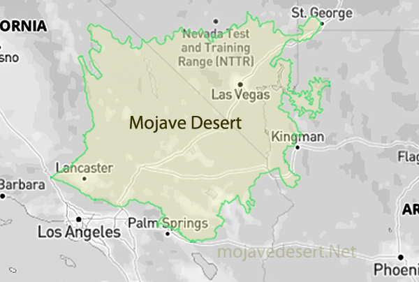
    Here is a look at what the Mojave is famous for, with pioneer trails and human history front and center:

    1. Native Peoples
      Long before wagon wheels, the Mojave was home to Native tribes like the Mojave, Chemehuevi, Southern Paiute, and Serrano. These communities knew the springs, passes, and seasonal rhythms like the back of their hand, and they left trails, trade routes, rock art, and village sites throughout the region. Their knowledge of water and survival shaped later explorers’ routes.
    2. Pioneer Trails
      • Old Spanish Trail: This historic trade route linked New Mexico to California, winding through the Mojave. Traders, herders, and explorers used it to move livestock and goods—often braving vast dry stretches and rugged terrain.
      • Mojave Road (aka Government Road): Originally a Native footpath, it became a vital wagon route in the 1800s, linking the Colorado River to Southern California. Army outposts like Fort Mojave and Camp Cady were built along it to protect travelers.
      • Salt Lake Wagon Road and Bradshaw Trail: These overland trails helped connect remote mining districts and settlements, pushing westward expansion through incredibly harsh country.
      • Butterfield Overland Mail Route: This short-lived but famous stagecoach line cut through the edge of the Mojave to deliver mail between St. Louis and San Francisco.
    3. Homesteaders, Miners, and Ranchers
      Once the trails were blazed, the floodgates opened to prospectors, settlers, and ranchers. Boomtowns sprang up around gold, silver, and borax. Think Calico, Tecopa, Kelso, and Ballarat—all born of dreams and dust. Cattlemen like Albert Swarthout carved out rough but sustainable ranches, running cattle from the low desert to summer pastures in the San Bernardino Mountains.
    4. Railroads and Route 66
      The Santa Fe, Southern Pacific, and Atlantic & Pacific Railroads stitched the desert into the country’s growing infrastructure. Later, Route 66 brought travelers through towns like Barstow, Needles, and Amboy, adding roadside Americana to the desert’s legacy.
    5. Modern Tribes of the Desert
      Today, the Mojave is home to desert dwellers of all stripes—scientists, artists, loners, and communities like the Mojave Indian Tribe, who still live near the Colorado River. It also draws off-grid homesteaders and folks seeking freedom in wide open country.
    6. Endurance and Ingenuity
      Whether you’re talking about ancient foot trails, covered wagons crossing dry washes, or early aviators launching into the unknown, the Mojave has always demanded toughness and adaptability. It’s a place that doesn’t hand out easy victories—but the stories it holds are worth every blister and rattlesnake dodge.