Early reports of mineralization and occasional prospecting activity in the Resting Springs Range and southern Amargosa area.
1877
William D. and Robert D. Brown discover the Noonday and Gunsight mines, uncovering high-grade silver-lead ore that draws attention to the Resting Springs Mining District.
1878
Jonas Osborne incorporated the Los Angeles Mining and Smelting Company after acquiring claims, including the Noonday and Gunsight mines. Backed by Los Angeles investors, he builds a smelter and begins ore processing in the Tecopa region.
1880s
Borate minerals, including colemanite and ulexite, are identified in the Amargosa region, setting the stage for major borax mining ventures.
1904
F.M. “Borax” Smith incorporates the Tonopah & Tidewater Railroad (T&T) to connect the borate fields of southeastern California and Nevada with transcontinental rail networks at Ludlow, CA.
1905
Development begins at the Lila C. Mine in the Amargosa Desert, a major source of colemanite. The mine becomes central to Smith’s borax empire.
1906
The Biddy McCarthy Mine is located east of Tecopa, initially developed for silver and lead, but later became known for its production of talc.
1907
The Tonopah & Tidewater Railroad reaches Tecopa and Death Valley Junction, revolutionizing freight and passenger access in the remote desert mining district.
1909
The Tecopa Railroad Company is incorporated to build a short-line spur connecting the Noonday mines to the T&T at Death Valley Junction.
1910
The Tecopa Railroad begins ore haulage, efficiently moving silver-lead ore from the mines around Tecopa to the main T&T line for shipment to smelters.
1916
First talc claims are filed in the Southern Amargosa Range, particularly in the Ibex Hills and Eagle Mountain area. The region begins shifting toward talc production.
1918
Ore haulage declines on the Tecopa Railroad as major silver-lead mines begin to play out. Following postwar economic shifts and reduced output, the railroad entered a period of gradual decline, although it remained in limited use into the 1920s.
1920s
The Biddy McCarthy Mine reaches peak production as a talc operation. With silver and lead in decline, talc becomes the district’s primary mineral commodity.
1930s
U.S. Gypsum and other firms expand talc mining near Tecopa. Industrial demand for talc supports continued use of legacy mining infrastructure and revitalizes some sites.
1938
The Tecopa Railroad is dismantled. With mining activity diminished and trucking on the rise, the short line is no longer economically viable. Its removal marks the end of an era in desert mining logistics.
1910–1912 – Survey and planning begin for a rail line to support the construction of the Los Angeles Aqueduct.
1912–1914 – Construction of the Jawbone Branch (also called the Lone Pine Branch) by the Southern Pacific Railroad. It runs from Mojave to Owenyo, about 90 miles.
1914–1920s – Line supports agriculture, mining, and the cement industry; connects with the narrow-gauge Carson & Colorado at Owenyo.
1930s–1940s – Steam locomotives dominate operations; regular mixed freight runs continue, including to and from Trona and Inyokern.
1950s–1960s – Diesel locomotives gradually replace steam. Traffic declines but continues, with some military use near Inyokern.
1970s – Operations decrease; the northern end of the line sees fewer trains.
1982 – A fire damages Tunnel #1 near Searles. The northern section from Searles to Lone Pine is shut down.
1990s – Rails removed north of Searles.
2000s–present – Southern portion near Trona still used by Trona Railway. Most of the branch is abandoned, but it is still traceable by grade and remnants.
1. Living with the Land Many desert communities still reflect an old ethos of self-reliance. Places like Twentynine Palms, Pahrump, or Joshua Tree grew from homesteads, mining camps, or military needs. Water scarcity, scorching summers, and isolation shaped the people into a tough, adaptable bunch. Modern residents still contend with those same challenges, but with solar panels and smartphones added to the mix.
2. Shifting Economies Historically rooted in mining, ranching, or railroad work, today’s desert towns often rely more heavily on tourism, military contracts, retirees, and the arts. Communities like Borrego Springs and Tecopa attract visitors with their hot springs, stargazing opportunities, and solitude. Others, like Barstow and Victorville, thrive as transportation hubs or bedroom communities for larger cities.
3. Cultural Identity Places like Oatman, AZ, Shoshone, CA, or Mesquite, NV lean into their Wild West or Native heritage, preserving historic buildings and community traditions. Festivals, murals, and local museums help keep old stories alive while welcoming the curious traveler.
4. Environmental Awareness Today’s desert dwellers are more aware of environmental limits. Desert greening, sustainable housing, and native landscaping are catching on. Communities are beginning to view the desert as a partner, rather than something to be conquered. Water rights, off-grid living, and wildfire risk are hot-button issues.
5. Challenges Growth is a double-edged sword. With an increase in population comes higher traffic, increased housing costs, and pressure on limited water and land resources. Places like Lancaster, Apple Valley, or Hesperia are experiencing rapid expansion while trying to maintain a sense of identity.
In short: Today’s desert communities are caught in a tug-of-war between honoring their rugged roots and adapting to modern pressures—whether that’s solar farms on old ranchland, tech workers moving into old mining towns, or artists setting up studios where homesteaders once dug wells.
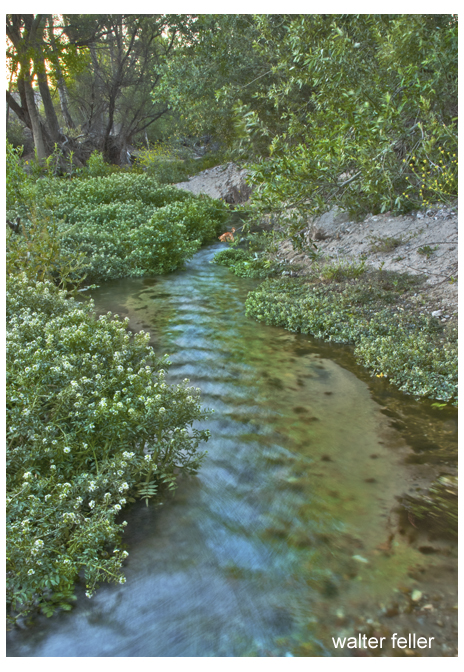
This is a lovely and tranquil capture of Cajon Creek. The flowing water creates a gentle sense of movement through the composition, beautifully complemented by lush greenery along its banks. The subtle reflection of the trees and sky adds depth and interest, making the scene feel peaceful and inviting. The soft, diffused lighting enhances the calming atmosphere. Compositionally, the curve of the creek guides the viewer’s eye naturally through the image. A slight increase in contrast or clarity might make the textures pop a little more vividly, but overall, it’s a charming and well-executed photograph.
This is a beautiful long-exposure photograph of a flowing stream over mossy rocks. Here’s the critique and rating:
Composition:
The use of the rocks to anchor the flow is well-executed, especially the striking striped rock in the lower right, which adds visual interest.
The scene feels intimate and immersive, pulling the viewer into a quiet, almost meditative space.
The flow of water naturally guides the eye across the image, suggesting motion and calm.
Lighting & Color:
Low light conditions were managed well. The smooth, silken look of the water against the sharp, textured rocks and moss creates a strong contrast.
The green tones in the moss are rich but subdued—natural rather than over-saturated.
The color palette leans dark overall, which adds a moody, tranquil atmosphere; however, it slightly obscures details in the upper section.
Technical Aspects:
The long exposure is effective and well-balanced, with no overexposure or blown highlights in the water.
The focus is crisp on the rocks, particularly the striped one, which serves as a visual focal point.
There’s a delicate balance between softness in the water and sharpness in the static elements—nicely done.
Suggestions:
Brightening just the midtones or selectively dodging parts of the moss could bring out more detail and give the image a subtle lift without ruining the mood.
Cropping a bit from the top might tighten the composition, keeping focus on the dynamic lower half.
Rating: 8.7/10 A well-executed, contemplative nature shot with pleasing composition and masterful exposure control. The image quietly invites the viewer to pause and observe the small, beautiful rhythms of nature.
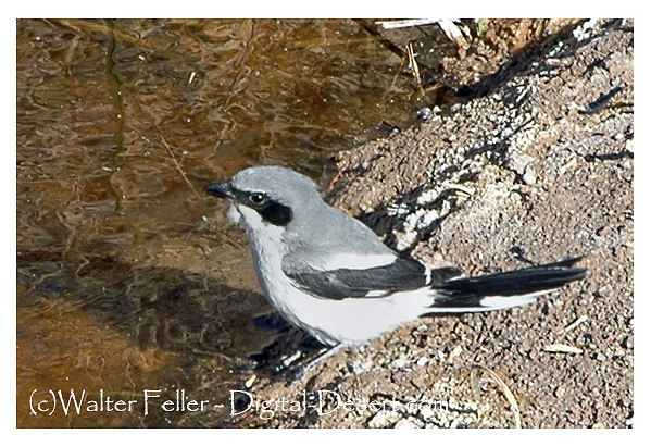
The loggerhead shrike—often referred to as the “butcher bird”—has earned a curious and somewhat eerie reputation in desert folklore, particularly in the Mojave and Sonoran Deserts.
Here’s a simplified and humanized look at the folklore surrounding this odd little predator:
The Bird That Hunts Like a Hawk Despite its modest size (about that of a robin), the loggerhead shrike is known for its ruthless hunting habits. Lacking the strong talons of a hawk or owl, the shrike compensates by impaling its prey—lizards, insects, even small rodents—on thorns, cactus spines, or barbed wire. This macabre method has led desert dwellers to view it with a mix of admiration and superstition.
Folklore and Old-Timer Tales In desert lore, the shrike is sometimes seen as a messenger or omen. Because it kills and displays its prey so visibly, early ranchers and Native desert tribes alike noticed it and gave it symbolic weight:
Omen of Change or Warning: Some desert ranch hands said that seeing a shrike’s “death stick” near camp was a sign to stay put—or else suffer bad luck. The more violent the display (such as a lizard pierced on a cholla), the more serious the warning.
Protector of the Land: Among some desert storytellers, the shrike was oddly respected, even seen as a “guardian of the brush,” keeping the balance by dispatching pests like grasshoppers or snakes. Its bloody tactics were just nature’s way of handling things efficiently.
The Desert’s Executioner: One old Mojave tale tells of a shrike that would impale “bad souls” in bird form—cursed spirits who had done wrong in life. The bird would catch them in disguise, hang them on cactus thorns, and leave them for the buzzards. It was seen as a kind of cosmic justice carried out by nature.
Cultural Parallels The loggerhead shrike’s unusual behavior also found its way into cowboy poetry and even modern conservation stories. Some saw the shrike as a desert metaphor: small but fierce, adaptive, and unflinching—a fitting image for the harsh yet beautiful world it inhabits.
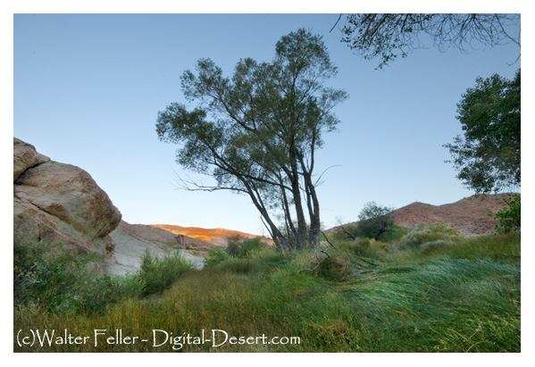
Last Chance Spring – Redrock Canyon, California State Park
This is a strong and serene desert landscape photograph, likely taken near sunrise or sunset based on the lighting. Here’s a breakdown of the critique and a rating:
Composition (8.5/10): The tree positioned slightly off-center creates a natural focal point and draws the viewer’s eye toward the warm light on the distant hills. The composition follows a gentle rule of thirds, and the curved rock on the left adds grounding weight. There’s a pleasant balance between open sky, rocky terrain, and green foreground.
Lighting (8/10): The warm rim of light on the far hillside contrasts beautifully with the cool tones in the shaded foreground. This balance adds depth and mood to the photo, although the shadowed areas may be slightly flat. A slight bump in contrast or exposure for the foreground might enhance detail without losing the early light ambiance.
Color and Texture (8.5/10): Great range here—cool greens and blues in the foreground and sky, warm hues in the distance. The grasses and tree details provide texture that adds to the sensory impact of the scene. Slight haze or early morning softness fits the mood well.
Mood and Atmosphere (9/10): This photo evokes quiet solitude and the feeling of being in a hidden desert oasis. The mix of vegetation, sandstone, and pastel sky is classic Mojave. It’s peaceful and timeless.
Technical Quality (8/10): It appears sharp and clean, though perhaps a tad soft at the edges, which may be intentional to enhance the dreamlike quality. There’s no obvious distortion, and dynamic range is handled well.
Final Rating: 8.5/10 A well-composed, peaceful desert landscape that invites the viewer to pause and explore. It subtly captures the contrast and harmony found in desert environments—harsh rock, soft light, and surprising greenery.
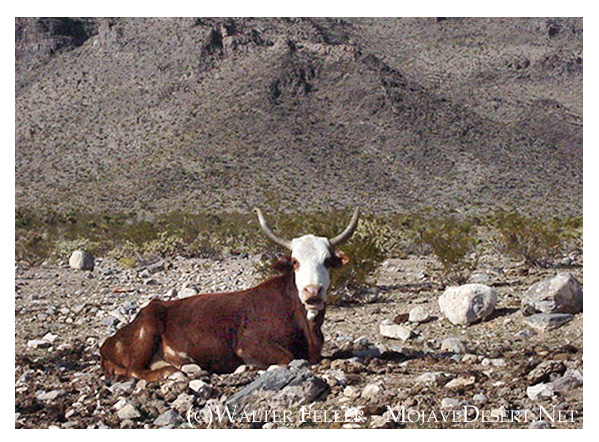
The cow is the clear focal point, positioned almost dead-center, which gives the image a straightforward, documentary feel. While this works for identification, shifting the cow slightly off-center would add visual interest.
The background is flat but expansive, conveying a sense of isolation and vastness—typical of open-range desert scenes.
Lighting & Color
Harsh daylight casts minimal shadow, resulting in a flat overall tone. Morning or evening light could create more contrast and mood.
Color is natural and subdued—browns and tans dominate, blending the cow into its surroundings a bit too much. A stronger separation between subject and background would help.
Narrative & Tone
The cow’s stance and the empty landscape suggest solitude and endurance, though the image stops short of telling a full story. Including another cow or a sign of human activity (like a trough or fence line) might deepen the narrative.
The image leans more toward utilitarian than artistic—this could be intentional, especially for documentary or archival use.
Technical Observations
Focus is good; the cow is sharp, and background elements are nicely blurred.
The horizon is level, which is essential in landscape shots.
There’s some dead space above and beside the cow, which could be tightened or reframed to emphasize the subject.
Summary: This image works well as a straightforward record of a lone cow in a desert setting. It’s honest and functional. For stronger visual impact or storytelling, a few changes in light, framing, and background elements would elevate it from reference to expressive photograph.
6 out of 10.
Why 6?
+2 for clear subject and sharp focus
+2 for honest, documentary value
+1 for capturing natural environment and mood
+1 for decent composition and exposure
-1 for flat lighting and lack of visual depth
-1 for minimal storytelling or emotional engagement
-1 for slightly awkward centering and framing
With some adjustments—especially in light, timing, and narrative context—it could easily reach an 8 or 9.
A hundred years ago—around 1925—the Mojave Desert was a land of stark contrast: wild and wide open, yet dotted with signs of human ambition. Here’s what it was like back then:
1. Railroads Ruled the Desert: Steam engines crisscrossed the Mojave, linking mining camps, military posts, and towns. The Tonopah & Tidewater, Santa Fe, and Union Pacific lines were lifelines, hauling ore, supplies, and people. Sidings and water stops, such as Bagdad, Kelso, and Ludlow, bustled with activity.
2. Mining Booms Still Echoed: Many boomtowns had already peaked—places like Calico, Rhyolite, and Panamint City were fading—but borax, gold, and silver mining continued. Boron’s giant deposit was discovered just around that time (1925), setting the stage for future industrial mining.
3. Rugged Settlements and Homesteads: Scattered homesteaders, prospectors, and ranchers tried to carve out a living. Water was precious, and so were shade and company. Windmills spun over hand-dug wells, and mail came by mule or train.
4. Roads Were Primitive: Highways were mostly graded dirt or gravel. Route 66 had just been designated that year (1925), but paving was still spotty. Motorists faced long, isolated stretches with little more than a gas pump and maybe a café every 40 miles or so.
5. Indigenous Displacement Ongoing: Mojave, Chemehuevi, Paiute, and other Native peoples still lived in the region, though most had been pushed to reservations or marginalized communities. Traditional knowledge of the land persisted, but the pressures of assimilation and loss of territory were heavy.
6. Forts Fading, but Military Still Present: The old frontier forts like Fort Mojave and Camp Cady were history by then, but the Army still trained in the desert and surveyed for future uses. The military interest in desert space would only grow in coming decades.
7. Harsh but Beautiful: You’d find desert bighorn, kit foxes, roadrunners, and thriving groves of Joshua trees and creosote. Spring wildflowers carpeted the land after rare rains. Flash floods, dust storms, and brutal heat shaped daily life—and survival.
8. The Desert as Frontier Myth: Writers, photographers, and curious travelers were beginning to romanticize the Mojave as a mysterious American frontier. The desert was both feared and admired—a place where outlaws vanished and fortunes were still whispered about.
In essence, the Mojave of 1925 was a tough, raw land with threads of industry, survival, and myth pulling through the scrub and stone. It wasn’t the end of the world—but you could see it from there.
Thirty years ago, around 1995, the Mojave Desert was a quieter, less-developed place compared to today, but the seeds of change were already taking root. Here’s a snapshot of what it was like back then:
1. Less Development, More Open Space: Many desert towns, such as Victorville, Hesperia, and Palmdale, were still transitioning from small high desert communities into bedroom suburbs for Los Angeles. You could drive long stretches without spotting a gas station or subdivision.
2. Military and Mining Still Strong: Fort Irwin, Edwards Air Force Base, and China Lake were in full swing, fueling local economies. Some small-scale mining was still active, especially for gold and borates, though not nearly at the scale of earlier decades.
3. Old Highways Still in Use: I-40 had bypassed Route 66 in the late ’80s, but by 1995, old stretches through places like Amboy and Ludlow were still drivable and saw occasional travelers chasing nostalgia.
4. Fewer Tourists, Less Regulation: Joshua Tree hadn’t yet become a national park (that happened in 1994), so it still had more of a remote, rustic feel. Off-roading was looser, backcountry camping was less regulated, and you didn’t need a timed entry to watch the sunrise.
5. Fading Ghost Towns: Places like Rhyolite, Ballarat, and Goldfield were in a quieter state of decay—few tourists, fewer interpretive signs—just you, the wind, and the ruins.
6. The Environment: The desert was showing early signs of environmental stress—growing urban sprawl, invasive species like tamarisk spreading along washes, and increasing off-road vehicle damage. But wildflower seasons still dazzled when the rains came right, and bighorn sheep still roamed less-disturbed ranges.
7. Culturally: You’d find more old-timers living out of trailers, caretaking abandoned mining camps, or running desert curiosity shops. The new wave of artists, climbers, and Instagrammers hadn’t yet arrived in full force.
In short, the Mojave of 30 years ago felt emptier, rougher around the edges, and more like the “last frontier” than it does today. A place still living in its own time, even as the modern world started to catch up.
10,000 BCE – 1700s Native peoples, including the Southern Paiute and Western Shoshone, used the Tecopa, Shoshone, Resting Springs, and Amargosa River areas for thousands of years. Springs like Willow Creek and Ibex Springs supported seasonal camps and trade routes connecting the Mojave Desert to the Great Basin.
1829–1830 Antonio Armijo led the first successful trade caravan along what became known as the Old Spanish Trail. His route passed near Resting Springs and the future sites of Tecopa and Shoshone, helping establish a commercial corridor between New Mexico and California.
1844–1859 Resting Springs became an important stop on the Mormon Road, used by emigrants and freight teams. Conflicts occurred between Native groups and travelers. Chief Tecopa led local Paiute resistance before later reaching a peace agreement with settlers. In 1859, Lt. Williamson of the U.S. Army surveyed and recorded Resting Springs as a critical water stop.
1875–1880s A mining boom brought the founding of Brownsville, later renamed Tecopa, near Willow Creek. Prospectors also worked claims at Ibex Springs, building stone cabins and hauling ore by mule. Resting Springs was reoccupied briefly as a supply stop. Tecopa declined after richer discoveries nearby.
1900 Quon Sing, also known as Ah Foo, developed China Ranch near Tecopa by irrigating fields along Willow Creek. He grew fruit and raised livestock, leaving a legacy that remains part of the landscape today.
1907 The Tonopah and Tidewater Railroad reached Tecopa and Shoshone. A new townsite, called the Tecopa Triangle, was built closer to the rail line. Mining resumed with easier access to markets.
1910 Shoshone was founded by “Dad” Fairbanks as a rail stop and supply point for nearby mines. It soon had a general store, schoolhouse, and housing for workers.
1920s Mining activity increased at Ibex Springs. Shoshone continued to grow, and Tecopa Hot Springs began to attract visitors as a health retreat. The Shoshone post office was moved from the ghost town of Greenwater.
1930s Women in Shoshone built the Flower Building for community events. Miners lived in hand-dug dwellings at Dublin Gulch. Mining at Ibex Springs continued at a small scale.
1957 Major mining operations in Tecopa ended. The town shifted toward tourism and retirement. Shoshone remained a traveler’s stop on the way to Death Valley.
1960s–1970s Under the Small Tracts Act, new homes were built in Tecopa Heights. Ibex Springs was abandoned. Conservation efforts began to grow for the Kingston Range and Amargosa Basin.
1976 The area was included in the California Desert Conservation Area, giving it federal protection. Resting Springs was identified as a riparian habitat and cultural site.
1994 Death Valley became a National Park. Shoshone’s role as a gateway town increased. The Kingston Range and Nopah Range were designated as wilderness areas, preserving places like Ibex Springs.
2000s–present The Amargosa Conservancy acquired and protected lands around Tecopa, China Ranch, and the river. Shoshone established a museum and promotes its heritage. Tecopa hosts annual events such as the Tecopa Takeover and Firehouse Fling. A public water kiosk was installed in Tecopa Heights. Ibex Springs remains accessible by high-clearance vehicle, with stone ruins and old mining structures still visible.
The Mojave Desert has always been a land of extremes—of survival and ambition, of quiet persistence and sudden booms. Two cornerstone texts help tell this story: “Pioneer of the Mojave” by Richard D. Thompson and “Desert Fever” by Vredenburgh, Harthill, and Shumway. Though they cover different periods and perspectives, together they trace the transformation of the Mojave from a sparse frontier to an industrialized desert landscape.
Pioneer of the Mojave introduces us to Aaron G. Lane, one of the first permanent settlers along the Mojave River in the 1850s. His crossing became a lifeline for travelers, freighters, and military expeditions. Lane’s story represents the early days, when survival hinged on access to water, good judgment, and cooperation with those passing through. His efforts in agriculture, trade, and hospitality helped anchor the Mojave as something more than space on a map.
But the story doesn’t end with the settlement.
Desert Fever picks up where the pioneers left off, charting the feverish rush for gold, silver, borax, and copper that swept across the California desert in the late 19th and early 20th centuries. Boomtowns sprang up where campsites once stood. Trail stops like Daggett and Calico became freight hubs. Water from the Mojave River—once used to grow alfalfa—was now hauled to stamp mills and ore crushers.
Both books share the same landscape, but their characters have different goals. Lane and his peers sought stability. The miners and speculators who came later chased their fortunes, often leaving ghost towns in their wake. What links them is the land itself—unforgiving but full of possibility.
By exploring both books side by side, we see the Mojave Desert not just as a backdrop but as a central character in its own evolving history.
Suggested Section Links (for below this intro):
Pioneer of the Mojave → [Link to your Lane’s Crossing or full PDF/summary]
Desert Fever → [Link to chapter index or embedded content]
Related topics: [Mojave River history], [Daggett], [Panamint City], [Mining in the Mojave]
M. Penn Phillips was a bold and ambitious real estate developer who believed in turning wide-open land, often desert or high-country wilderness, into thriving communities. Starting in the 1920s and continuing into the 1960s, he spearheaded numerous developments, primarily in California’s deserts, mountains, and inland valleys. Some projects found their footing; others fell short. But all bear the stamp of Phillips’ flair for promotion and his dream of reshaping the American West.
One of his earliest ventures was Frazier Mountain Park, launched in 1924 in the mountains of Kern County. Phillips built a lodge, created five artificial lakes, and sold hundreds of cabin lots to folks looking for a cool-weather retreat. The area is still known today as Frazier Park.
In the late 1920s, he set his sights on Nevada, carving up large tracts of desert outside Las Vegas and marketing them to people hoping to stake a claim near what would eventually become a booming city. These Las Vegas tracts were speculative—sold well before the Strip or Hoover Dam existed—but laid the groundwork for future development.
Around the same time, Phillips was busy acquiring tens of thousands of acres along the Colorado River, which straddles the Arizona-California border. Though no town came from it, this was classic land-banking—buying cheap desert land and selling it to dreamers, retirees, and speculators.
After World War II, as Southern California experienced rapid growth, Phillips focused on the Antelope Valley, subdividing desert land near Palmdale and Lancaster. He marketed these parcels to veterans and working families, banking on the growing aerospace industry nearby to drive settlement.
By the early 1950s, he’d moved into the Victor Valley, laying out Mountain View Acres near Victorville. These were one-acre lots with few frills—just raw land and a chance to build your own home on the cheap. That do-it-yourself spirit carried over into Apple Valley and beyond, where Phillips sold off more desert tracts with promises of clean air, open skies, and low prices.
He didn’t stop there. He offered land across the Mojave, from Barstow to Newberry Springs, always touting affordability and opportunity. Not every buyer got rich, but enough people came to plant the seeds of small desert communities.
Phillips’ biggest swing came in Hesperia. Starting in 1954, he acquired over 23,000 acres and developed a comprehensive city plan, featuring homes, businesses, a man-made lake, a golf course, and his signature “U-Finish Homes.” These were houses built with finished exteriors but unfinished interiors—buyers were expected to finish the drywall and floors themselves. It was cheaper that way, and it attracted a wave of do-it-yourselfers. Hesperia eventually became a city, though much of Phillips’ vision was scaled back or scrapped due to infrastructure problems and unrealistic timelines.
Then came Salton City, a bold plan on the western shore of the Salton Sea. Between 1958 and the early 1960s, Phillips laid out thousands of lots and built streets, a yacht club, a hotel, and even a golf course. Sales were explosive—millions of dollars’ worth of lots sold in just one weekend. But the sea turned brackish, the infrastructure crumbled, and the dream fell apart. Today, Salton City is a shadow of what was promised, with paved streets stretching out into the desert, most still awaiting homes that never materialized.
He even sold land in the Big Bear Lake area, offering cabin sites in the mountain pines. These were some of his more modest and enduring projects, quietly blending into an already popular resort region.
From mountain lakes to desert shores, Penn Phillips left behind a scattered legacy of ambition and overreach. Some of his projects sparked the creation of real towns. Others remain little more than maps and memories. But taken together, they paint a vivid picture of one man’s attempt to reinvent the West, one parcel at a time.
List of Penn Phillips Projectsin High Desert & Mountains
Frazier Mountain Park – Frazier Park, CA (1924) Mountain resort community with lakes, lodge, and recreational amenities.
Las Vegas Tracts – Las Vegas Basin, NV (1927) Early speculative desert subdivisions before major city growth.
Colorado River Basin Lands – AZ/CA border (1929–1932) Large-scale desert land acquisition and resale, not tied to any one town.
Palmdale & Lancaster Tracts – Antelope Valley, CA (Late 1940s) Ranch and residential lots near growing aerospace centers.
Victorville – Mountain View Acres – Victorville, CA (Early 1950s) 1-acre home lots, early desert subdivision still populated today.
Apple Valley Subdivisions – Apple Valley, CA (Late 1940s–1950s) Home and ranch parcels sold in conjunction with other desert ventures.
Barstow & Newberry Springs – San Bernardino County, CA (Late 1940s–1950s) Remote residential and farm lots; many remain undeveloped.
Hesperia – Hesperia, CA (1954–1960s) Master-planned community featuring “U-Finish Homes,” a lake, and a resort vision.
Salton City (Salton Riviera) – Salton Sea, CA (1958–1960s) Massive planned resort town with marina, golf course, and yacht club – later failed.
Big Bear Lake Area Tracts – San Bernardino Mountains, CA (1940s–1950s) Cabin and mountain home sites in a growing resort region.
Maximilian Franz Otto Strobel, better known as Max Strobel, was a Bavarian immigrant, surveyor, and land developer who played a significant yet quiet role in shaping Southern California in the late 1800s. He is remembered today as Anaheim’s first mayor and a driving force behind the early movement to create what would eventually become Orange County. But his ambitions stretched even farther—into oil, railroads, colonization schemes, and one particularly bold plan to develop a vast stretch of desert land that later became Hesperia.
Born in 1826 in Bavaria, Strobel was caught up in the political unrest of the 1848 revolutions in Europe. Like many young idealists of his time, he joined in the fighting and had to flee once the revolution failed. He made his way to the United States in 1851, landing in New York and quickly finding work as a surveyor for the U.S. government.
His skills earned him a spot on John C. Frémont’s 1853 expedition to find a transcontinental railroad route across the Rockies. Strobel survived bitter winter conditions and rough terrain to help complete the survey. From there, he briefly joined the infamous filibusterer William Walker in Nicaragua, an adventure that ended in chaos and a narrow escape.
By the late 1850s, Strobel had made his way to California, where he worked on Frémont’s Mariposa Estate before jumping into early oil exploration in Los Angeles County. He drilled in Brea Canyon and helped manage one of the area’s first petroleum ventures—well ahead of its time. Around 1865, he settled in Anaheim, a small German farming colony, and quickly became involved in civic life.
In 1870, Max Strobel became Anaheim’s first mayor. With a vision for local self-rule, he spearheaded a campaign to break away from Los Angeles County and form a new county, which he hoped would be called Anaheim County. He even launched a newspaper, The People’s Advocate, to rally support. The effort failed, but it laid the groundwork for what would eventually become Orange County in 1889.
Around the same time, Strobel participated in a large land deal in the upper Mojave Desert. Acting as an agent for a syndicate, he helped purchase about 50,000 acres near the Mojave River—an area that would one day become Hesperia. The land was chosen with the hope that a major railroad line would soon pass through, boosting land value and attracting settlers. But the railroad didn’t arrive for nearly 15 years. Investors lost patience, and the project was scrapped.
The land later passed into the hands of a German temperance colony—a group hoping to establish a dry, orderly settlement in contrast to the wine-making culture of Anaheim. While this effort didn’t take root, it paved the way for the eventual founding of Hesperia during the land boom of the 1880s, when the Chaffey brothers and their partners attempted again to build a model town. This time, the railroad had arrived, but lasting success was still slow to come.
Meanwhile, Strobel had turned to other ventures. In 1872, he traveled to London to broker the sale of Santa Catalina Island and other California properties to British investors. The deal was close to closing when Strobel died suddenly in his London hotel room in early 1873. The exact cause was never made public, and his death remains something of a mystery.
Strobel died without fanfare, and for decades his name slipped into obscurity. It wasn’t until the late 20th century that local historians in Anaheim began to rediscover his contributions. Today, Max Strobel is remembered as a bold, restless figure—part dreamer, part doer—whose plans didn’t always work out, but who helped lay the foundations of Southern California as we know it.
Sources: Historical accounts from the Los Angeles Times, Anaheim local history archives, and Mojave Desert regional histories have been used in compiling this biography. Notable references include Richard Buffum’s “Father of Orange County Loses Some Mystery” (LA Times, Feb. 22, 1987)latimes.com, the Anaheim Public Library’s records on Strobel (via J. Rubio’s 2014 research)anaheimhistory.blogspot.com, and the Mojave Desert historical report “Once Upon a Desert” (1976) detailing the Hesperia land scheme digital-desert.com, scvhistory.com, among other sources as cited above. Each provides insight into the fascinating, multifaceted life of Max Otto Strobel.
This chart shows the rise of 24 ghost towns across the Mojave Desert, mapping the years they were founded to the time they reached their peak. Each line marks the lifespan of a boom, whether driven by silver, gold, borax, or the railroads. Some towns flared up fast and vanished just as quickly, while others lingered for decades before fading into silence. This visual timeline provides a concise overview of how these desert outposts fit into the broader narrative of Western expansion and the mining fever that accompanied it.
The Hesperia Land and Water Company was established during Southern California’s great land boom of the mid-1880s. In 1885, Dr. Joseph P. Widney – a prominent Los Angeles figure and former president of USC – joined with his brother, Judge Robert M. Widney, and the Chaffey brothers (George and William Chaffey, renowned for developing Ontario, California) to form the company. That year, Joseph Widney acquired approximately 35,000 acres of Mojave Desert land (previously assembled by Max Strobel in 1869–1870) and laid out a townsite for a new colony. They named the settlement “Hesperia,” derived from a Greek term meaning “western land,” which reflected its location at the western edge of the desert.
The town plan featured broad streets – reportedly laid out in a grid with unusually wide rights-of-way, lined with shade trees – as part of an envisioned modern desert utopia. The initial tract included most of Township 4 North and parts of 5 North, Range 4 West, spanning the Mojave River’s west mesa and upper valley.
Early on, the developers sold about 2,000 acres (including a strategic dam site at the Upper Mojave Narrows) to help start the adjacent railroad town of Victor (Victorville), while reserving the mesa lands for Hesperia’s development. By late 1885 the California Southern Railroad (Santa Fe) had completed its line up through the Cajon Pass, and a small depot at Hesperia was in service, positioning the area for incoming settlers and tourists.
Development of the Hesperia Irrigation System and Water Rights Securing a reliable water supply was crucial to the colony’s agricultural ambitions. In early 1886, the company staked an ambitious claim to the flows of Deep Creek (the east fork of the Mojave River). Following frontier water law, Hesperia Land & Water placed a stone monument on the creek in 1886 to give public notice of its appropriation: an enormous 5,000 miner’s inches of water (per minute) to be diverted for use on the Hesperia lands. This volume, equivalent to around 125 cubic feet per second, was touted as enough water for tens of thousands of people, far anticipating the needs of the few settlers then present. The claim, which accounted for virtually all of Deep Creek’s flow, was intended to ensure Hesperia’s future growth and establish priority over downstream users. Indeed, the filing for 5,000 miner’s inches in 1886 would become the basis of Hesperia’s water rights for decades, and the company later asserted that it had continuously used this water each year for 20 years – thereby “proving up” its rights. The initial water works, begun in 1887, were hailed as a marvel of engineering: the so-called Hesperia Ditch and pipeline system. Engineers excavated a diversion channel in solid rock high in Deep Creek Canyon and built a diversion dam and intake above the Forks (where Deep Creek joins the West Fork Mojave). From there, water was carried about four miles in an open, concrete-lined canal along the canyon wall. At the Mojave River, the flow dropped into an inverted siphon – a 14-inch diameter riveted steel pipeline that ran 1¼ miles under the riverbed and up the opposite side to the Hesperia Mesa. The pipeline then extended several more miles across the mesa, totaling five miles of pipe, and emptied into an earthen reservoir near today’s Lime Street (this reservoir had a capacity of about 58 acre-feet). By 1888, the Hesperia irrigation system was operational, capable of delivering roughly 40 second-feet of water to the mesa. The colony used the water to plant orchards (notably apples) and other crops; at peak in the late 1880s, about 1,000 acres of farmland in Hesperia were under irrigation from this system.
Securing the water was not without conflict. Almost as soon as Hesperia’s plans became known, farmers and landowners downstream along the Mojave River (in Victorville, Oro Grande, and beyond) objected strenuously to this large upstream diversion. They feared Hesperia’s ditch would diminish the Mojave’s flow that sustained their ranches. Legal challenges and threats were raised even “before a spade was turned”, but Robert Widney and his company pressed ahead regardless. The Hesperia canal was completed and water was flowing by 1888, despite the protests. However, the dispute over Deep Creek water rights simmered and would resurface in later years. Hesperia’s appropriation was recorded with San Bernardino County and stood as a senior claim. Still, competing schemes would test it, most dramatically the Arrowhead Reservoir project in the early 1900s (discussed below) that aimed to impound the headwaters for use outside the desert.
Town Promotion, the Hesperia Hotel, and Railroad Connections
The Hesperia Land and Water Company undertook energetic promotional efforts to attract buyers and settlers to their desert colony. As a centerpiece of the development, the company constructed the grand Hesperia Hotel in 1887. This was a three-story, 36-room hotel built of adobe bricks (freighted in from Oro Grande), then painted a distinctive red. The hotel was intended to serve as both comfortable lodging for prospective land purchasers and a resort destination in its own right, capitalizing on the desert climate and scenery. Promotional literature described Hesperia as a healthful, idyllic community where irrigation would “make the desert bloom.” Wide, tree-lined streets and a planned town center were mapped out, and the availability of ample water for homes and farms was heavily advertised. Excursion trips were likely arranged, as the new railroad line made Hesperia accessible from Los Angeles and San Bernardino. Indeed, by 1885, the California Southern Railroad (part of Santa Fe) had established a station at Hesperia, which became a regular stop along the line through the Victor Valley. This rail connection was crucial in bringing in investors during the boom. The company also laid out a small business district near the station and hotel, anticipating an influx of commerce. By 1890, Hesperia boasted not only the hotel but also a general store, a post office, and a schoolhouse to serve the nascent community. All of these improvements were in place just as Southern California’s speculative land frenzy was reaching its zenith. For a brief moment, Hesperia appeared poised to become a thriving agricultural colony and tourist retreat in the high desert.
Collapse in the 1887–1888 Land Bust
Hesperia’s boom was short-lived. In 1887, the inflated real estate market across Southern California abruptly crashed, bringing land sales to a standstill. The grand plans of the Hesperia Land and Water Company began unraveling almost immediately after the costly infrastructure was built. By mid-1888 – barely six months after the hotel and other facilities were finished – the regional land boom went “bust,” and demand for Hesperia lots evaporated. Many of the investors and would-be settlers simply never arrived, leaving the new town with a handful of residents and far more lots than people. The company, having expended enormous capital on land, waterworks, and the hotel, found itself unable to generate revenue. A general economic depression particularly affected land development companies in the late 1880s, and Hesperia was no exception. The ambitious irrigation system that had been Hesperia’s pride became a financial liability, expensive to maintain with too few customers paying for water. In the 1890s, cultivated acreage shrank significantly as orchards and fields were abandoned due to a lack of farmers. The Hesperia Hotel, once a showpiece, largely stood empty; it survived into the 20th century but never fulfilled its original purpose as a luxury resort. Contemporary accounts began referring to Hesperia as a “ghost town” – a fate sealed by the collapse of the 1880s land boom. The Hesperia Land and Water Company itself slid toward insolvency. It made no further progress on expanding irrigation and could not finance crucial improvements like a storage reservoir to capture winter flows (needed to ensure summer water supply). Periodic flash floods even damaged the pipeline – the steel siphon under the Mojave River was washed out several times around the turn of the century. By 1909, the system had temporarily ceased delivering water to Hesperia. Essentially, the Grand Desert Colony project lay dormant and failed as a private venture, awaiting reorganization.
James G. Howland’s Role in Hesperia’s Early History
One name often mentioned in local reminiscences of early Hesperia is James G. Howland. Although not listed among the original incorporators, Howland appears to have been a key leader on the ground during the colony’s formative years. Contemporary reports and later historical sketches suggest that James G. Howland acted in a managerial or executive capacity for the Hesperia Land and Water Company, overseeing daily operations and promotion of the townsite. Some accounts refer to Howland as effectively leading the company’s efforts in Hesperia – for example, directing the sales campaign and perhaps supervising the construction of the infrastructure. Dr. Joseph Widney and the Chaffeys provided the vision and capital, but it was figures like Howland who carried out the practical development work. Howland’s background is less documented in published sources; he may have been an associate of the Chaffeys or an experienced land agent hired to manage the Hesperia project. By local lore, he was the “resident booster” for the town, responsible for guiding tours of the property and extolling the new colony’s potential. Archival information on Howland is sparse, but it’s known that he remained involved at least until the collapse of 1888. After the land bust, Howland fades from the record – it’s unclear whether he stayed on the desert or moved to other ventures. Nonetheless, his early leadership in Hesperia earned him a spot in the town’s historical memory. Modern historical summaries credit Howland as having “led” the Hesperia Land and Water Co.’s promotional push, even if his name did not appear in official founder lists. He is an example of the many 19th-century development promoters whose work was critical to these boomtown schemes, even if later overshadowed by the marquee investors. (Further biographical details on James G. Howland have proven elusive in available archives, suggesting that dedicated research in regional archives or newspapers might be needed to flesh out his story.)
Reorganization under the Appleton Land, Water and Power Company (1911)
After two decades of stagnation, Hesperia got a second chance in the early 20th century. In 1911, the assets of the defunct Hesperia Land and Water Co. were purchased and restructured by a new investment group under the name Appleton Land, Water and Power Company. This company was essentially the successor to the original colony enterprise, formed with an authorized capital stock of $300,000 (similar to the original). The Appleton group – reportedly led by P.D. Hatch of Los Angeles – aimed to revive Hesperia’s agricultural potential and make the faltering water system viable. Upon taking over in 1911, Appleton immediately set about rehabilitating and upgrading the infrastructure. They relined the old intake canal from Deep Creek. They replaced the unreliable siphon pipeline with a brand new, larger-capacity steel pipe in a better location under the Mojave River. Specifically, approximately four miles of new 30-inch riveted steel pipe were laid, including a redesigned inverted siphon that crosses the river – a substantial improvement over the old 14-inch line.
Portions of the original pipeline leading to Hesperia were retained, but much of the system was modernized. A concrete diversion dam (20 feet long) with proper headgates was built on Deep Creek to control and measure the flow into the conduit. Through these efforts, Appleton increased the canal’s capacity to an estimated 40 cubic feet per second and aimed to bring more land under irrigation. To separate utility operations from land sales, the Hesperia Water Company was formed in 1915 as a subsidiary public service entity. With a $40,000 capital investment, the Hesperia Water Co. took over the distribution of water to local users, leasing the water rights and facilities from Appleton, and came under the regulation of the state Railroad Commission as a public utility. This move “divorced” the water service from the colonization business, recognizing that the two required different management. By 1916, however, irrigation under the revived system was still modest – only about 310 acres (90 in orchards and 220 in alfalfa and corn) were being watered. Appleton L. W. & P. Co. controlled roughly 20,000 acres of land (the bulk of the original holdings), with approximately 18,000 acres of that accessible by the new mainline pipe; however, they had not yet succeeded in attracting large numbers of settlers to purchase and farm the land. The new company continued to supply water to the neighboring town of Victorville. Notably, the Victorville water system (serving that community by the river) was owned and operated by Appleton as of the late 1910s. Despite the improvements, Hesperia’s growth continued to be slow. The Appleton company’s strategy eventually shifted more toward long-term land holding and leasing water, rather than immediate large-scale colonization. Nonetheless, the 1911 reorganization preserved Hesperia’s water rights and infrastructure for the future, preventing the project from collapsing entirely.
Legal Disputes over Deep Creek Water (Arrowhead Reservoir Company Conflict)
Hesperia’s water rights claims soon faced a serious challenge from outside interests. In the late 1890s and early 1900s, a consortium of Los Angeles and San Bernardino investors formed the Arrowhead Reservoir Company, with the intention of damming Deep Creek (and other headwaters in the San Bernardino Mountains) to divert water southward to the growing cities of the San Bernardino Valley. This plan directly threatened the Mojave Desert communities because it would have siphoned off the source of the Mojave River. Starting around 1902, a prolonged legal and political battle unfolded between Arrowhead Reservoir Co. and virtually all Mojave River water users, prominently including the Hesperia Land and Water Co. and its successors. W.A. Field, who was president of Hesperia Land & Water around this time, led the fight on behalf of the desert interests. Hesperia’s position was that its prior appropriation and use of Deep Creek (dating back to 1886) gave it a superior right that would be harmed if Arrowhead built its dam. In formal filings and court actions, Field and the company argued that the Arrowhead project would “deplete, obstruct or eradicate” the natural flow of water into the Mojave River, thereby violating Hesperia’s vested rights and devastating the farms that depended on that water. The Hesperia company asserted control over some 33,000 acres along the river and marshaled evidence of its water claims: notably a filing for 1,000,000 miner’s inches of flood flow on both forks of the Mojave (an enormous claim made in the early 1900s to preempt Arrowhead). Hesperia pointed out that its claim predated Arrowhead’s by over two years, and furthermore, that for 20 years it had continuously taken about 5,000 miner’s inches from Deep Creek for use on the Hesperia mesa, establishing an “inviolable right” through continued beneficial use. In 1906, while Arrowhead Reservoir Co. began constructing a dam at Little Bear Valley (what would become Lake Arrowhead), Hesperia’s allies (including other ranchers and a group of midwestern investors who had bought up downstream rights) prepared to build a dam of their own in Victor Valley to capture water for local use. A flurry of lawsuits ensued. In 1909, numerous riparian landowners in the Mojave River basin – bolstered by Hesperia’s claims – filed suit to enjoin Arrowhead from diverting the mountain waters out of the basin. These cases dragged on for years. Ultimately, the desert interests prevailed: Arrowhead’s scheme to export Mojave water was halted. By the time Arrowhead’s dam (Lake Arrowhead) was completed in 1922, it was for recreational and local use only; the courts had prohibited the company from sending water south to San Bernardino. The precious Deep Creek flows continued down into the Mojave River, securing the water supply for Hesperia and its neighbors. This protracted legal victory was significant – it protected the Victor Valley’s lifeline and affirmed the priority of Hesperia’s 19th-century water appropriation. Decades later, those same rights would be recognized in comprehensive water adjudications for the Mojave Desert.
Long-Term Influence on Hesperia and the Victor Valley Though the Hesperia Land and Water Company’s original venture did not immediately blossom into the thriving colony its founders envisioned, it left a lasting imprint on the High Desert’s development. The town of Hesperia itself survived in diminished form – a “ghost that refuses to die,” as one historian later put it – thanks largely to the water infrastructure and land surveys put in place in the 1880s. The wide streets laid out by Widney and the Chaffeys became the skeleton of the Hesperia community that would finally grow many decades later. Most importantly, the company’s early establishment of water rights on Deep Creek ensured that Hesperia and surrounding areas had a secured share of water for future use. This proved crucial for the valley’s long-term viability. The successful defense against the Arrowhead Reservoir diversion preserved the Mojave River flows for local agriculture and settlement through the 20th century. Communities like Victorville and Apple Valley thus continued to have access to water, allowing them to expand. In fact, the Hesperia project indirectly spurred development elsewhere in the Victor Valley: for example, in the 1890s some of Hesperia’s unused land was planted in vineyards, producing raisins and wine that briefly gave the Hesperia name a positive reputation. The idea of desert land reclamation persisted – Appleton Land & Water Co.’s efforts in the 1910s to grow apples and alfalfa in Hesperia were an outgrowth of the original dream. While those early orchards never reached large scale, they demonstrated the desert’s agricultural potential under irrigation.
In the long run, the greatest impact of the Hesperia Land and Water Company was to anchor a settlement at the top of the Cajon Pass that could later be revived. Indeed, after World War II, the Victor Valley experienced a new land boom. In 1954, the remaining 35,000-acre Hesperia ranch (still essentially the same tract the Widneys had assembled) was sold to a development syndicate, the Hesperia Land Development Company. This mid-20th century effort, building on the old townsite and water system, finally succeeded in sparking substantial growth. By the late 1950s, Hesperia was marketing itself as an affordable residential community for Southern Californians, and population began rising. The city of Hesperia incorporated in 1988, a milestone that would have been impossible without the foundations laid by the 1885 company. The influence of that original company is also evident in the region’s infrastructure: the general route of today’s water deliveries in Hesperia traces back to the Deep Creek diversion engineered in the 1880s. The Victor Valley’s agricultural and urban development throughout the 20th century – from ranches to suburbs – was enabled by the water rights and pioneering spirit of those early entrepreneurs. In sum, the Hesperia Land and Water Company’s ambitious attempt to “make the desert bloom” did not prosper on the first try, but it set in motion the land acquisitions, legal rights, and vision of a desert community that eventually became reality. Hesperia and its neighboring High Desert towns owe a considerable debt to that 1880s boom-era venture for establishing their place on the map and securing the water that sustains them to this day.
Sources: Historical records and analyses were drawn from local history publications, engineering reports, and archival documents, including the State of California Dept. of Engineering Bulletin No. 5 (1918) on Mojave River irrigation, Edmund Jaeger’s “The Ghost that Refuses to Die” (Desert Magazine, Aug. 1954), San Bernardino County historical chronicles, and contemporary accounts and legal filings regarding water rights (e.g. Van Slyke v. Arrowhead Reservoir Co., 1909). Newspaper archives and local museum materials corroborate the roles of key figures like the Widneys, Chaffey brothers, and James G. Howland in Hesperia’s founding. The city of Hesperia’s own historical overview and marker texts were also consulted for confirmation of dates and figures.
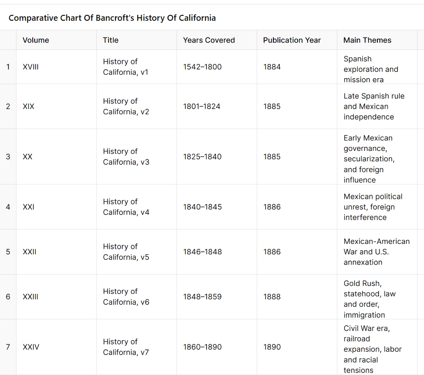
Comparative Chart of Bancroft’s History of California
Introduction and Usage for the Chart:
This chart provides a structured overview of the seven-volume series on California written by Hubert Howe Bancroft as part of his History of the Pacific States of North America, published between 1884 and 1890 by The History Company. Each entry summarizes the key historical themes covered in that specific volume, giving readers a chronological and thematic guide from the first European contact in 1542 through California’s political, social, and economic transformation up to 1890.
Usage:
Historical Reference: Quickly identify which volume covers a specific era or subject, such as the mission system, Mexican secularization, or the Gold Rush, before delving into the primary source.
Curriculum Planning: Useful for educators or researchers designing units around specific periods (e.g., Spanish colonization, Mexican California, U.S. annexation, or statehood).
Topical Exploration: Locate the volume that best discusses themes like land ownership, Native relations, immigration policy, political revolutions, or railroad monopolies.
Comparative Study: Observe how governance, economy, and cultural landscapes shifted across three regimes—Spanish, Mexican, and American—over nearly 350 years.
This chart serves as a compact gateway to Bancroft’s monumental historical work, facilitating both in-depth scholarship and broad contextual understanding of California’s complex past.
Mark Raymond Harrington was an American archaeologist who played a significant role in uncovering what became known as the “Lost City” in southern Nevada. The site, appropriately named Pueblo Grande de Nevada, comprises a series of ancient Native American settlements located along the Muddy River in the Moapa Valley. These sites were occupied from roughly 300 B.C. to around A.D. 1150.
In 1924, two brothers, John and Fay Perkins, discovered ruins and reported them to Nevada’s governor, James Scrugham. The governor contacted Harrington, who was associated with the Museum of the American Indian in New York. Harrington led the first major excavations, which began that same year.
The remains included pit houses and later adobe pueblos—some of which were over 100 rooms in size—built by the ancestral Puebloan people. The press began referring to the site as the “Lost City,” although Harrington preferred the formal name.
In the 1930s, the construction of Hoover Dam posed a threat to the area as the rising waters of Lake Mead would soon flood many of the sites. Harrington, with support from the National Park Service and the Civilian Conservation Corps, organized salvage excavations to recover as much material as possible before the site was inundated.
In 1935, the Lost City Museum (then known as the Boulder Dam Park Museum) was constructed near Overton, Nevada, to preserve and display artifacts from the site. The museum still operates today.
Harrington’s work was among the first to demonstrate the western extent of the Puebloan cultural world and remains a foundational chapter in the archaeology of the Mojave and Southwest deserts.
(1922) edited by John Brown Jr. for San Bernardino County (and James Boyd for Riverside County), is a two-volume regional history published by the Lewis Publishing Company. This work provides detailed biographical sketches, historical overviews, and profiles of early settlers, professionals, politicians, and businesspeople from the Inland Empire region of Southern California.
Key Details:
Full Title:History of San Bernardino and Riverside Counties: With Selected Biography of Actors and Witnesses of the Period of Growth and Achievement
Publication Date: 1922
Publisher: Lewis Publishing Company
Editors:
John Brown, Jr. – responsible for San Bernardino County sections
James Boyd – responsible for Riverside County sections
Contents:
Volume I: Covers the general history of the two counties, including early exploration, mission influence, settlement, economic development (ranching, mining, agriculture), and infrastructure like railroads and irrigation.
Volume II: Devoted largely to biographical sketches of notable individuals—pioneers, community leaders, business owners, and public officials.
Notable Features:
It contains firsthand accounts and detailed family histories, many of which are not found elsewhere.
The editors relied on interviews and submissions from local families and civic leaders, making it a valuable source for genealogical and regional research.
The book reflects early 20th-century values and perspectives, often idealizing the pioneer spirit and the “civilizing” of the region.
Author: Luther A. Ingersoll Published: 1904 Publisher: L. A. Ingersoll, Los Angeles
This book is a comprehensive county history covering:
Spanish and Mexican periods, including mission and rancho life
American annexation and early settlement
Civic and commercial development through the 19th century
Detailed accounts of railroads, mining, agriculture, and early towns
Biographical encyclopedia of prominent citizens, often including portraits
Descriptions of landmarks, institutions, disasters, and political events
The content is divided into historical narrative chapters followed by hundreds of biographical sketches.
The book is available online for free at archive.org and can be searched by keyword or browsed by page. A physical reprint is also available through various sellers.
“An Illustrated History of Southern California” is a historical volume published in 1890 by The Lewis Publishing Company. It is part of a larger series of regional histories from that era, each covering a different part of the United States. These books were often subscription-based vanity publications, meaning they included detailed biographies and histories submitted (and sometimes paid for) by the individuals or families featured.
Here’s what you should know about this specific volume:
Full Title: An Illustrated History of Southern California: Embracing the Counties of San Diego, San Bernardino, Los Angeles, and Orange, and the Peninsula of Lower California Published: 1890 Publisher: The Lewis Publishing Company, Chicago
Contents Summary:
Early Exploration and Settlement:
Spanish exploration (notably Juan Rodríguez Cabrillo and Gaspar de Portolá)
Mission system and colonization under Spanish and Mexican rule
Mexican and Early American Period:
Mexican land grants and ranchos
The transition to American governance post-1848 (Treaty of Guadalupe Hidalgo)
California statehood and its impact on the region
Development of Counties and Towns:
Growth of cities like Los Angeles, San Diego, and San Bernardino
Railroads, agriculture (especially citrus and vineyards), and real estate booms
Biographical Sketches:
Hundreds of pages of biographies of prominent settlers, businessmen, ranchers, and civic leaders
Often includes portraits and details about personal achievements, land holdings, and social connections
Illustrations:
Engravings and lithographs of important buildings, early maps, ranch homes, street scenes, and individuals
Use and Value Today:
It serves as a primary source for historians, genealogists, and researchers
The biographies provide insight into settler perspectives, economic development, and social hierarchies of the late 19th century
The illustrations and engravings are valuable for understanding the visual landscape of the era
Note of Caution: While rich in historical detail, the book reflects the biases of its time—including Eurocentric views, boosterism, and often omitting or minimizing Native American perspectives.
Little Lake is a small, spring-fed lake tucked between volcanic cliffs and a red cinder cone along California’s Highway 395. To most modern travelers, it’s just a quick blur on the drive north through the high desert. But beneath its quiet surface lies a deep and layered past—one shaped by ancient peoples, rugged prospectors, and enterprising families who turned this desert watering hole into a hub of life and legend.
A Desert Legacy Thousands of Years Old
Long before roads or railroads existed, Little Lake served as a seasonal home to Native American groups that lived and moved throughout the Mojave and Great Basin deserts. Archaeological findings suggest that humans camped here as far back as 10,000 years ago, drawn to the dependable water and abundant resources.
Rock art etched into the black basalt cliffs tells part of this story. Petroglyphs depict figures with atlatls, mountain sheep, and human forms, suggesting the spiritual and practical aspects of these early people’s lives. Over the centuries, different cultural traditions passed through, but one of the most important was the Pinto Culture. This group lived in the region several thousand years ago and left behind signature dart points and evidence of circular house foundations—some of the oldest in California.
Among the most intriguing discoveries is the so-called “Pinto Man,” a human burial found in a shallow grave near the lake, buried with a stone point. Excavations also revealed beads, tools, and a vast amount of obsidian flakes—remnants from toolmaking that still litter the ground today. The presence of local obsidian sources made Little Lake a crucial location for the production and trade of stone tools throughout the Southwest.
Lagunita and the Stagecoach Years
In the 1860s, Little Lake gained new importance. Mexican prospectors called it “Lagunita”—meaning “little lagoon”—as it offered the first fresh water after a dry stretch when traveling north from Indian Wells. When the Cerro Gordo mines boomed in the Eastern Sierra, Little Lake became a natural stop along the Visalia-to-Independence stage line.
A stone station was built here to water horses and rest travelers heading to and from the silver mines. Wagons loaded with ore, mail, and supplies rolled through regularly, and the station saw steady use for over a decade. Its reputation was such that, for many years, it remained untouched by bandits. Folklore tells of the infamous outlaw Tiburcio Vasquez sparing the station out of gratitude.
However, that peace was broken in 1875 when Vasquez was captured and executed. Shortly afterward, one of his lieutenants led a group of bandits to Little Lake, robbing the station and tying up the staff. It was the only known robbery during the stop’s operation—and a sign that times were changing. Within weeks, a new stage route bypassed Little Lake, and the old stone station was left to the wind and sun.
The Railroad Arrives
At the turn of the 20th century, Little Lake stirred back to life. Homesteaders like Charles Whittock filed claims and set up adobe ranch houses on the lake’s shore. In 1910, the Southern Pacific Railroad extended its tracks through the area, laying them across the marsh on wooden trestles. A small station was established, and a community began to take shape.
With the railroad came more people—workers, ranchers, and travelers. The growing village eventually took the name “Little Lake,” and a post office opened to serve the community. A few homes, a store, and a small hotel clustered near the tracks. When automobile travel expanded, Little Lake became a convenient stop for early motorists navigating the desert roads.
Bramlette’s Desert Resort
In the early 1920s, a man named William Bramlette saw potential in the quiet lakefront. An auto racer-turned-developer, Bramlette, purchased the land and the old buildings. He dammed the lake’s outlet to deepen the water and cleared the tule reeds. To control vegetation, he released muskrats—an idea that didn’t work out as hoped—but the result was a mile-long lake that could support fishing and boating.
Bramlette built a two-story lodge from concrete and native stone. The Little Lake Hotel, completed in 1923, became the centerpiece of a desert resort. He added a café, general store, service station, and cabins for guests. The lake was stocked with bass and crappie, and Southern Californians came in droves to fish, swim, and escape the city heat. Duck hunters found Little Lake especially inviting during the fall migration, and a private duck club was soon established.
For decades, the Bramlettes ran a bustling operation. The lava rock lodge became a landmark along the highway. Highway 6, later renamed U.S. 395, brought families, fishermen, and outdoor enthusiasts. Children played under cottonwoods while travelers dined, refueled, or stayed the night before continuing north.
Volcanoes, Waterfalls, and Ancient Trails
Little Lake is situated in a dramatic geological setting. The dark cliffs along the lake are ancient basalt flows from volcanic activity that occurred long ago. Just north of the lake lies Fossil Falls—a deep, sculpted gorge carved by meltwater from ancient glaciers. Though dry today, Fossil Falls shows the powerful interaction of water and lava in prehistoric times. Red Hill, a vivid cinder cone, stands nearby, a reminder of more recent eruptions.
The obsidian found around Little Lake originates from local volcanic domes and has been traced to campsites across the western desert. This made Little Lake part of a much larger trade and migration network for Indigenous peoples who came for the toolstone, water, and seasonal game.
Decline and Quiet Legacy
By the 1950s, Little Lake began to fade. In 1958, Highway 395 was rerouted to bypass the village. Traffic and business dropped. The railroad fell out of use and was abandoned by 1981. The Little Lake Hotel remained for several more decades, but after a devastating fire in 1989, it was never rebuilt. The post office closed in 1997, marking the end of permanent settlement.
Today, Little Lake is privately owned and used primarily as a wildlife refuge and seasonal hunting preserve. The lake continues to host migratory waterfowl and serves as habitat for fish and other wildlife. Archaeological protections ensure that its ancient history will not be lost. Occasionally, researchers and rock art enthusiasts visit the area under guided conditions to study its cultural treasures.
Though few structures remain, the spirit of Little Lake endures. It’s a place where volcanic forces and human stories meet—where early desert peoples chipped tools from obsidian, where stagecoaches stopped under the stars, and where modern families once came to fish and rest.
Little Lake may be quiet now, but its story runs deep, etched into stone, whispered in the wind, and remembered by those who still seek out the desert’s hidden corners.
The Cushenbury Grade is a steep and winding stretch of mountain road that climbs from the high desert of Lucerne Valley up to the pine-covered town of Big Bear Lake. Today, it’s part of California State Route 18, but long before pavement and guardrails, this canyon trail served miners, ranchers, and Native travelers through the San Bernardino Mountains.
Before roads were built, the Serrano people used footpaths through Cushenbury Canyon to move between desert and mountain environments. These routes followed natural contours through the rugged terrain and were later adopted by settlers.
By the 1860s and 70s, prospectors, cattlemen, and freighters were dragging wagons up and down this slope. During the gold boom in nearby Holcomb Valley, Cushenbury became one of the main north-side routes into Big Bear. It was grueling work—steep grades, loose rock, and no guarantee your wagon would make it to the top in one piece.
The canyon and grade took their names from the Cushenbury family, early settlers and cattle ranchers in the Lucerne Valley area. Their name stuck, and by the early 20th century, the area gained new attention, not for gold but for limestone.
In 1918, rich limestone and marble deposits were discovered along the grade. This sparked industrial interest, and by the 1950s, Kaiser Cement had developed a massive limestone quarry near the top. A narrow-gauge rail system carried raw material down the grade to a processing plant: even today, trucks loaded with cement rumble up and down the slope.
During the 1960s, the state upgraded the road and officially folded it into California State Route 18. This brought pavement, safety improvements, and better access to Big Bear from the desert side. Though safer now, the grade still features tight switchbacks and dramatic elevation changes, rising from about 3,000 feet in Lucerne Valley to over 6,700 feet at the top.
Today, the Cushenbury Grade remains a key route for both commerce and recreation. It offers expansive views of the Mojave Desert below and a sense of just how much effort it once took to reach the mountains. Whether hauling limestone or heading up for a weekend getaway, this road directly links two very different worlds—desert and alpine.
Timeline
Cushenbury Grade Historical Timeline
Pre-1800s: Indigenous Serrano people use Cushenbury Canyon as a seasonal travel route between the Mojave Desert and mountain forests.
1860s–1870s: Miners and ranchers began traveling through the canyon using rough trails to access Holcomb Valley and Big Bear. The steep terrain made it tough for freight wagons and livestock.
1880s: A more defined wagon road is carved into the canyon wall. It’s still rough going—narrow, rocky, and dangerous—but it’s one of the few ways into Big Bear from the desert.
Early 1900s: The Cushenbury family settles in the Lucerne Valley area, giving their name to the canyon and grade.
1918: Limestone and marble are discovered along the canyon. As mining gains momentum, the area shifts from wagon trail to industrial corridor.
1950s: Kaiser Cement develops a large limestone quarry near the top of the grade. A private rail system is built to haul material to the desert floor. This leads to improvements along the road.
1960s: The state paves and upgrades the road, officially making it part of California State Route 18. It becomes a year-round access route to Big Bear Lake from the high desert.
1990s–present: The Cushenbury Grade is heavily used by cement trucks and tourists. The steep climb and sharp turns remain challenging, especially in winter, but it’s a vital link between two different environments.
The Mojave River is a strange, beautiful thread of water in California’s high desert. Most of the time, you can’t see it. It hides beneath the sand, popping up only in rare places like Afton Canyon or the Narrows near Victorville. But this ghost river has a long and complicated past tied to shifting earth, ancient climates, lost lakes, and generations of people who relied on it.
It all began millions of years ago when tectonic forces pushed up the San Bernardino and San Gabriel Mountains. These rising peaks blocked older river systems that used to flow toward the Pacific. With nowhere to go, water from the mountains started pooling in the desert. Over time, a new river formed, trapped within these closed desert basins. That was the beginning of the Mojave River.
During the Ice Age, things looked very different. The Mojave River wasn’t just a trickle or an underground stream—it was a robust river that flowed year-round, fed by rain and snowmelt from the mountains. It carried water from the San Bernardino Mountains to a series of massive lakes out in the desert: Lake Manix near Barstow and Lake Mojave farther east. These were deep, wide bodies of water teeming with life. Around 18,000 years ago, Lake Manix overflowed, carving the dramatic Afton Canyon and sending a flood of water toward Soda and Silver Lakes, which became Lake Mojave. Fossils from this time show mammoths, saber-toothed cats, and even aquatic life like fish and freshwater snails around the river and lakes.
When the last Ice Age ended, the climate changed. It got warmer and drier, and the big lakes began to dry up. The river still carried water now and then, but only during the wet season, and it often disappeared underground. Over thousands of years, it became the ghost river we know today. Now, it flows mostly beneath the desert floor, surfacing briefly after storms or in spots where rock formations push it upward.
Despite its dryness, the Mojave River is the lifeblood of the western Mojave Desert. Its rare surface flows and hidden undercurrents recharge underground aquifers, feed oases, and support all kinds of desert life. You’ll find cottonwood trees, willows, and even small fish like the endangered Mojave tui chub in wetter stretches. Birds rely on it too, especially migratory species that need stopover habitat in the middle of a dry land. Some stretches, like Palisades Ranch and Afton Canyon, are rich in wildlife because of the river’s presence.
People have followed the Mojave River for thousands of years. Indigenous groups, especially the Vanyume (a branch of the Serrano), lived along its banks and used its waters to survive in the desert. It also became part of significant trade and travel routes, notably the Mojave Road. Spanish explorers like Father Garces followed it in 1776, and American mountain men like Jedediah Smith came through in the 1820s. Later, Mexican traders and Mormon pioneers used it to reach California.
In the 20th century, towns like Victorville, Barstow, and Daggett grew along the river. They pulled water from its aquifer for agriculture and homes. Over time, more groundwater was pumped out—more than was going back in. This led to water shortages and falling water tables. To fix it, water agencies began regulating pumping and importing water from Northern California to recharge the Mojave Basin. Today, the Mojave Water Agency closely monitors the river’s underground flow.
Climate change is also reshaping the river’s future. Bigger storms could cause major flooding, but longer droughts make the river even more fragile. Meanwhile, conservation groups are working to protect the remaining green places along the river—removing invasive tamarisk, planting native trees, and safeguarding habitat for birds, fish, and other wildlife.
So while the Mojave River may not look like much at first glance—just a dry wash running through the desert—it’s the thread that ties together this region’s natural and human story. From Ice Age megafauna to modern groundwater battles, the Mojave River has quietly shaped life in the desert for millennia.
When I was talking with my friend Rob, we got into a deep conversation—one of those wandering talks about life and how it works. We touched on something debated for centuries: Is life the result of a grand design, or does it all come down to natural processes like adaptation and survival?
This question goes back at least as far as 1802, when Reverend William Paley wrote Natural Theology. Paley famously compared living things to a watch. He argued that if you found a watch on the ground, you’d assume someone made it—a watchmaker. So why not assume the same about life? To Paley, all the complexity and beauty of living organisms was proof of a designer—God.
His words were strong: “There cannot be design without a designer… That designer must have been a person. That person is GOD.”
But about 50 years later, Charles Darwin shook that idea to its roots. In his view, nature didn’t need a conscious designer. Evolution worked through natural selection. Random changes (what we now call genetic mutations) sometimes gave organisms a slight advantage—better eyesight, a thicker coat, a clever escape trick. If those traits helped them survive and reproduce, they got passed on. Over time, those beneficial traits piled up, shaping the species—not by design, but by nature’s quiet filter.
That brings me back to Rob.
Rob had cats, though I never saw them. He’d let them roam his yard, but only when he was around to keep predators like coyotes or bobcats at bay. One thing he noticed: a cat would grab a lizard every now and then. In a flash of desperation, the lizard would drop its tail and run. It might look a bit silly, stubbed in the rear, but it lived to fight another day.
Soon enough, nearly all the lizards in his yard were tailless. Not because they were designed that way, but because the ones that couldn’t drop their tails had already been eaten.
That’s natural selection. It wasn’t part of a plan. The lizards didn’t “choose” to evolve that way. But those with the tail-dropping reflex survived more often, and if they went on to have baby lizards, that trait spread.
In Paley’s time, imagining something so complex as life not being intentionally built was hard. But what Darwin showed—and what Rob’s yard seemed to prove in its small way—is that nature doesn’t need a blueprint. It just needs time, variation, and a bit of pressure to sort out what survives and what doesn’t.
The Sierra Wave is a dramatic weather phenomenon on the eastern side of the Sierra Nevada Mountains, especially near places like Owens Valley. It’s a type of standing wave cloud, formed when stable, moist air is pushed up over the mountain range and then descends on the leeward (downwind) side.
Here’s a simple breakdown of how and why it happens:
Wind hits the Sierra Nevada: Westerly winds (from the Pacific Ocean) blow moist air toward the tall Sierra peaks.
Air rises and cools: As the air is forced up the mountains, it cools and condenses, forming clouds. This is the start of a lenticular wave pattern.
Wave formation: On the eastern side, the air sinks, warms, and then rises again in a repeating up-down wave pattern, like ripples in water.
Stationary clouds: If there’s enough moisture, lenticular clouds form at the crests of these waves. These are the classic “Sierra Wave” clouds—smooth, lens-shaped, and often stacked like pancakes.
Why they matter: These waves can cause extreme aircraft turbulence but also create ideal lift for gliders. Owens Valley is world-famous for sailplane pilots who “ride” the Sierra Wave to high altitudes—sometimes over 30,000 feet.
In short, the Sierra Wave is caused by strong winds, stable air, and the massive barrier of the Sierra Nevada, producing a beautiful but sometimes dangerous atmospheric wave on the eastern slope.
In the early 1850s, as the United States expanded westward, national interest grew in finding a viable transcontinental railroad route. Congress appropriated funds in 1853 for multiple surveying expeditions to explore different potential routes across the West.
Lt. Amiel Weeks Whipple
Under the direction of Secretary of War Jefferson Davis, the Army’s Corps of Topographical Engineers organized surveys along several parallels. Lieutenant Amiel Weeks Whipple, a West Point-trained engineer, was chosen to lead the study near the 35th parallel north, roughly following a westward line from Arkansas to California. The goal was to assess the terrain’s suitability for a railroad, measuring distances and grades, locating mountain passes, and noting the availability of water, timber, fuel, and other resources critical for railway construction. This effort was part of a larger Pacific Railroad Surveys program, which dispatched teams to investigate northern, central, and southern routes for the first transcontinental railroad.
John Milton Bigelow, a physician and botanist
Whipple was already an experienced surveyor. He had worked on the U.S.–Mexico boundary survey after the Mexican–American War and had a reputation for scientific thoroughness. For the railroad survey, Whipple assembled a multidisciplinary team of about seventy men, including Army soldiers for security, teamsters to handle the wagons, and a number of scientists and specialists. The Smithsonian Institution helped select many of the expedition’s experts, reflecting the survey’s dual nature as both a route reconnaissance and a scientific exploration of the largely unmapped Southwest. Notable members of Whipple’s party included John Milton Bigelow, a physician and botanist; Jules Marcou, a geologist from France; and Balduin Möllhausen, a German artist and naturalist who had the backing of famed explorer Alexander von Humboldt. Lieutenant Joseph C. Ives, a young Army engineer, served as Whipple’s second-in-command and led a sub-party during the journey. The team’s diverse expertise meant that, in addition to plotting a railroad route, they would document the region’s flora, fauna, geology, and ethnography in unprecedented detail.
Journey from Fort Smith to New Mexico Territory
Lt. Joseph Christmas Ives
Whipple’s expedition officially commenced in mid-July 1853 at Fort Smith, Arkansas, then a border outpost to Indian Territory (present-day Oklahoma). The caravan – a long train of wagons and pack animals – set westward from Fort Smith on July 15, 1853. The team initially followed established trails where possible: they crossed the Poteau River into Indian Territory and proceeded along rough wagon roads just south of the Canadian River. This path had been traversed a few years earlier by expeditions such as Captain Randolph Marcy’s 1849 wagon road survey to Santa Fe. Even so, much of the region remained sparsely charted. The landscape of eastern Oklahoma was a patchwork of settlements belonging to relocated Native American nations (Choctaw, Chickasaw, Creek, Seminole, Cherokee, among others). As they traveled through these inhabited areas, Whipple often sought advice and guides from local Native people. The party moved steadily but cautiously, averaging only a few dozen miles per day due to the heavy wagons and the need to survey as they went.
Throughout the Indian Territory, Whipple was struck by the relative fertility and land resources. In contrast to earlier notions of the Southern Plains as part of the “Great American Desert,” Whipple described parts of what is now Oklahoma in encouraging terms. His team noted ample timber stands in regions like the Cross Timbers and discovered occurrences of coal, both assets for any future railroad. They found the prairie soils suitable for agriculture, observing that the area could yield abundant crops with sufficient water. Wildlife was surprisingly scarce along their route at first (likely due to overhunting and the presence of settlements). Still, as the expedition progressed into less populated areas, they encountered more game, including herds of bison and the occasional bear on the plains. The surveyors also recorded observations on the Native tribes they met. Whipple, with an ethnographer’s eye, collected information on indigenous languages and customs. He and his colleagues compiled vocabularies of various Native languages and noted the social conditions of the tribes, many of whom had been relocated to the Territory. The hospitality of local Native leaders helped the party traverse the region; in return, Whipple’s reports portrayed the tribes in a largely favorable light and even noted their openness to the idea of a future railroad bringing new opportunities.
By late summer, the expedition reached the Texas Panhandle, entering an environment of open high prairie. Here, the going became more challenging – the trails were faint, water sources more intermittent, and the heat and dryness more intense. In early September, the party was trekking across the flat expanse known as the Llano Estacado (Staked Plain) in what is now the Texas–New Mexico border area. Despite the hardships of travel across these arid plains, Whipple remained optimistic about the route’s potential. He reported that much of the rolling prairie appeared well-suited for laying track, with gentle grades and few significant barriers. Occasional hazards did arise: at one point, massive prairie fires swept across the dry grasslands, forcing the survey team to move camp to avoid the flames hurriedly. Nevertheless, the expedition pressed onward without major incident by carefully timing their marches between water holes and taking guidance from seasoned frontier scouts.
In early October 1853, Whipple’s party reached Albuquerque in the New Mexico Territory. This was a significant milestone and a chance to regroup. Albuquerque had been an outpost on the old Santa Fe Trail, providing a place to resupply and rest after the long plains crossing. Here, the expedition was joined by Lieutenant Ives’s detachment, which had taken a slightly different approach route. Ives and a small group had traveled separately via a southern path, moving from the Gulf of Mexico through Texas (through San Antonio and El Paso) and northward up the Rio Grande to rendezvous with Whipple. The combined expedition, now fully assembled in Albuquerque, prepared to tackle the most demanding portion of the journey: the remote deserts and mountains between New Mexico and California. They hired an experienced guide, Antoine Leroux, a frontiersman familiar with western trails, to assist in navigating the unknown terrain ahead. As autumn turned to winter, Whipple’s caravan departed Albuquerque, heading west into increasingly rugged country.
Across Arizona and the Mojave Desert to California
Leaving the relative civilization of the Rio Grande valley, Whipple’s survey entered what is now Arizona – a land largely unmapped by Americans at that time. The expedition first passed through the lands of the Zuni Pueblo, one of the Indigenous villages in western New Mexico. Whipple was very interested in the pueblo cultures; he paused to exchange greetings and study their way of life briefly, even sketching and describing Zuni architecture and traditions for his report. The party struck out from Zuni across northeastern Arizona, traversing the Painted Desert region. They aimed for the Little Colorado River, which they reached by following ancient Native trails. This stretch was difficult: water and grass were scarce, and the winter cold began to set in. The surveyors likely encountered patches of snow as they ascended in elevation. Still, the group persevered, mapping the terrain carefully. They made note of volcanic formations and other geologic curiosities as they approached the lofty San Francisco Mountains (the San Francisco Peaks near modern Flagstaff, Arizona).
Guided by Antoine Leroux, the expedition found a pass through the San Francisco Mountains and descended into the basin of the Colorado River. By January 1854, they were in some of the most remote territory of the Southwest – a stark land of canyons and plateaus. Here, two Mohave Native American guides joined the party and proved invaluable. The Mohave people inhabited the river valley and deserts around the lower Colorado, and they knew the best routes through the arid labyrinth ahead. Under the guidance of these local scouts, Whipple’s team followed a path down a tributary called Bill Williams Fork to reach the Colorado River itself near the boundary of modern Arizona and California.
Crossing the Colorado River in the winter of 1854 was one of the expedition’s most significant challenges. The river was swift and cold, and the expedition had to build rafts or use whatever boats they could improvise to ferry men, animals, and equipment across. This crossing proveddisastrous – strong currents nearly swept away some of the party’s wagons and scientific collections. A makeshift raft capsized at one point, and several precious items (instruments and specimen jars) were lost to the muddy waters. Fortunately, no lives were lost, and Whipple managed to get his entire command safely to the western bank after considerable effort and delay. By February 7, 1854, the surveyors stood in California, having conquered the last significant natural barrier on their route.
Now the task remained to cross the vast Mojave Desert of southeastern California and reach the settled areas near the Pacific coast. The Mojave presented different obstacles: arid expanses, occasional sand dunes, and long stretches with no reliable water aside from a few springs. Still accompanied by their Mohave guides, Whipple’s party navigated along established Native trails that connected waterholes across the desert. They moved generally northwest from Colorado, eventually picking up the path of the old Mojave Road (a route used by Native Americans and the early Spanish travelers to California). This trail led toward the Mojave River, a critical lifeline in the desert. Following the Mojave River upstream (southwestward), the expedition could find water and grass for their stock at intermittent stream bends and oases.
Traveling along the Mojave River, Whipple noted signs of earlier travelers – evidence that this route had been used by Spanish missionaries, American fur trappers, and emigrant wagon parties in years past. They were approaching where the Mojave Road merged with the Old Spanish Trail and the newer Southern California wagon roads. The terrain gradually changed: dry lakes and creosote flats gave way to the higher elevations of the California Coast Range. The expedition’s final hurdle was to cross the San Bernardino Mountains via the Cajon Pass, the same pass used by traders and settlers to enter southern California. Cajon Pass was a natural mountain pass between the Mojave Desert and the coastal valleys. Whipple’s survey assessed this pass carefully, measuring its grade and width, and found it to be a favorable corridor for a railroad line. He reported that Cajon Pass, already well-traveled by wagons, could be engineered for locomotives without extraordinary difficulty – a significant affirmation, since this gap was the gateway to Los Angeles.
After emerging from Cajon Pass, the weary expedition descended into the green fields of southern California. They passed through the outskirts of San Bernardino, a young Mormon-founded community, and finally reached Los Angeles on March 20, 1854. This completed an epic journey of roughly 1,800 miles from the Mississippi River to the Pacific coast. Whipple’s team had spent about eight months on the trail, enduring extreme weather, rugged terrain, and occasional threats (from the environment more so than from people – indeed, relations with Native tribes along the way had been largely peaceful and cooperative). The triumphant arrival in Los Angeles marked the conclusion of the field survey. However, in many ways, Whipple’s work was just beginning: he now had to compile his findings and analysis for the government, recommending whether this 35th parallel route was suitable for a transcontinental railroad.
Scientific and Cultural Observations
Beyond its purely geographic accomplishments, the Whipple expedition made significant scientific and cultural contributions. It was, by design, a traveling research laboratory. The team’s specialists collected volumes of data and specimens throughout the trek. Botanist John Bigelow gathered hundreds of plant samples, discovering species new to science (many western plants would later be named in honor of Bigelow). Geologist Jules Marcou studied rock formations along the route, producing one of the first geological transects of the American Southwest – identifying coal seams and mineral deposits, and noting the volcanic origins of landscapes like the San Francisco Peaks. Topographical drawings and paintings by Balduin Möllhausen, the expedition artist, provided eastern audiences with their first realistic views of wonders such as pueblo villages, broad prairie vistas, and desert mountain ranges. Möllhausen also kept a personal journal describing daily life on the trail, which, along with the diary of assistant surveyor John P. Sherburne, offers vivid insights into the expedition’s experiences (both of these journals were later published and are valuable historical sources).
Lieutenant Whipple was intensely interested in ethnography (the study of cultures). As the expedition passed through regions inhabited by diverse peoples – from the settled Choctaw and Chickasaw farms in Indian Territory to the semi-nomadic Apache bands in New Mexico, the Pueblo villages, and the Mohave and Yavapai groups near the Colorado – Whipple took the time to observe and document their ways of life. He recorded information on tribal governance, agriculture, and daily customs. One notable effort was the compilation of vocabularies: Whipple’s report included comparative word lists for numerous Native languages encountered on the journey, preserving linguistic data that might have otherwise been lost. He was generally respectful in his descriptions, often noting the hospitality and helpfulness the survey party received. For instance, the Zuni and Mohave guides were crucial to the expedition’s success, and Whipple acknowledged their vital role in navigating the rugged country.
The scientific observations were not just academic; they directly tied into evaluating the railroad route’s feasibility. Whipple’s team cataloged where good timber stands grew (necessary for supplying wood for construction and fuel), where water was available year-round, and the locations of coal, iron, or other minerals that might support a railroad economy. In Oklahoma and New Mexico, they identified river valleys and mountain passes that could accommodate tracks with gentle gradients. In the drier sections of the route, they noted stretches that might require constructing wells or aqueducts to supply locomotives with water. The data collected on weather and climate led Whipple to an interesting conclusion: the 35th parallel route, he believed, had a climate “favored by precipitation” compared to some more northerly routes. In other words, he thought this middle-southern route received enough rainfall. He had enough perennial streams to sustain a railroad, without the extreme snowfalls that plagued routes farther north and without the absolute aridity of the far southern deserts. His final report reflected this climatic optimism, emphasizing the agricultural and settlement potential of the lands along the 35th parallel line.
Results and Legacy of the Expedition
Maj. Albert H. Campbell
Upon reaching California, Whipple and his colleagues turned to organizing their notes, maps, and collections. Over the next year, they prepared a comprehensive report for the War Department. Lieutenant Whipple authored the narrative of the journey and the analysis of the route’s suitability for a railroad. He highlighted that the expedition had identified a practicable rail corridor. There were only a few significant obstacles (notably the crossings of the Pecos and Rio Grande rivers and the passage through Cajon Pass), and even those could be overcome with engineering effort. Whipple’s engineer, A. H. Campbell, compared these challenges to building railroads in the Appalachians back east, implying that nothing in the West was insurmountable by modern (1850s) engineering standards. In Whipple’s estimation, the 35th parallel route offered an attractive balance: it was shorter than the far-southern route through Texas, avoided the highest peaks and snows of the central Rockies, and ran through regions that appeared fertile enough to populate and economically develop.
The U.S. government published the expedition’s official findings as part of a monumental series titled “Reports of Explorations and Surveys to Ascertain the Most Practicable and Economical Route for a Railroad from the Mississippi River to the Pacific Ocean.” Whipple’s report was contained in Volume III of the Pacific Railroad Survey Reports (1856), including his detailed narrative, maps, and journey illustrations. An accompanying Volume IV (1856) contained the scientific appendices: reports on geology, botany, zoology, and a significant essay by Whipple on the Native American tribes of the Southwest. These volumes were richly illustrated with lithographs based on Möllhausen’s sketches – images that introduced Americans to scenes like a Plains Indian encampment, a Pueblo village under the cliffs, and the majestic profiles of western mountain ranges. The reports were technical documents and essential works of natural science and anthropology for their time.
Balduin Möllhausen – writer, illustrator
Despite Whipple’s strong recommendation of the 35th parallel route, the decision on a transcontinental railroad was ultimately delayed by political conflict. In the 1850s, Congress remained deadlocked between Northern and Southern factions, each promoting different routes. No single route was chosen before the outbreak of the Civil War. Whipple’s careful survey, unfortunately, did not immediately lead to the construction of a railroad along his line. Indeed, when the first transcontinental railroad was finally built in the 1860s, it followed a more central route (far north of Whipple’s line) to connect Omaha with Sacramento. However, Whipple’s work was not in vain. His survey proved that a railroad could traverse the Southwest and helped identify the best passageways through a once-mysterious region. In the decades after the Civil War, railroad companies did turn to the 35th parallel corridor: the Atlantic and Pacific Railroad (later part of the Atchison, Topeka and Santa Fe Railway) built westward along much of Whipple’s path through New Mexico and Arizona. By the late nineteenth century, a transcontinental railway line was completed along the 35th parallel, validating Whipple’s original vision by providing a direct rail link to Los Angeles through the Mojave Desert.
The Whipple expedition also left a lasting legacy in science and exploration. The enormous collection of plant and animal specimens sent back east enriched American museums and led to the description of new species. The detailed maps produced by Whipple’s cartographers became base maps for the Southwest, used by future travelers, the military, and settlers. His ethnographic notes provided scholars with early documentation of Native cultures in regions that would soon experience dramatic change. Additionally, members of Whipple’s team went on to notable careers: Joseph Ives later led his famous expedition to explore the Colorado River in 1857; Balduin Möllhausen published his illustrated diaries and became known in Europe as an author on the American frontier; and Amiel Whipple himself continued his Army service, ultimately becoming a Union general in the Civil War (tragically, he was mortally wounded at the Battle of Chancellorsville in 1863).
In summary, Lt. Amiel W. Whipple’s 1853–1854 survey along the 35th parallel was among the most successful and influential Pacific Railroad Surveys. It combined meticulous route reconnaissance with scientific inquiry, painting a comprehensive picture of the lands between Fort Smith and Los Angeles. Whipple demonstrated that a railroad through the Southern Plains and Southwest was feasible and revealed the economic promise of that region. His expedition’s findings, published in the Pacific Railroad Survey volumes and subsequent works, helped guide the nation’s understanding of the Southwest and paved the way—literally and figuratively—for future railroads and settlements along his route.
Sources
Reports of Explorations and Surveys… Volume III (1856).Route near the Thirty-Fifth Parallel, under the command of Lt. A. W. Whipple. Washington: War Department, 1856. (Official Pacific Railroad Survey report with Whipple’s narrative, maps, and illustrations.)
Reports of Explorations and Surveys… Volume IV (1856). Washington: War Department, 1856. (Contains Whipple expedition’s scientific reports on geology, botany, zoology, and appendices on Native American tribes.)
Foreman, Grant (ed.). A Pathfinder in the Southwest: The Itinerary of Lieutenant A. W. Whipple during his Explorations for a Railway Route from Fort Smith to Los Angeles in 1853 and 1854. Norman: University of Oklahoma Press, 1941.
Gordon, M. M. (ed.). Through Indian Country to California: John P. Sherburne’s Diary of the Whipple Expedition, 1853–1854. Stanford, CA: Stanford University Press, 1988.
Conrad, David E. “The Whipple Expedition in Arizona, 1853–1854.” Arizona and the West 11, no. 2 (1969): 147–178.
Goetzmann, William H. Army Exploration in the American West, 1803–1863. New Haven, CT: Yale University Press, 1959.
Elmer’s Bottle Tree Ranch is one of those places that feels like it grew straight out of someone’s imagination—and in a way, it did. Set along Route 66 in Oro Grande, California, it started with a father and son combing the desert for old glass bottles. Elmer Long’s dad had a passion for collecting, and when he passed, Elmer inherited a garage full of dusty, colorful bottles. Not one to let them sit idle, he started welding up metal trees in his yard and placing the bottles on them like leaves catching the sunlight.
By the early 2000s, Elmer’s yard had turned into a shimmering forest of bottle trees, each topped with bits of found junk—old signs, gears, rifles, and typewriters. It wasn’t just art, it was a conversation. Travelers on Route 66 would pull over, and Elmer would greet them, eager to share stories and hear a few in return.
When Elmer died in 2019, his son Elliott took over the care of the ranch, keeping its spirit alive. Today, it still stands as a glowing patch of creativity in the desert—free to visit and impossible to forget.
Colorado Desert: Southeastern California; part of the larger Sonoran Desert, focused around the Salton Trough and lower Colorado River.
Sonoran Desert: Covers southeastern California, southern Arizona, and extends into Mexico.
Mojave Desert: This desert is mostly in southeastern California and also parts of Nevada, Arizona, and Utah. It lies north of the Colorado and Sonoran deserts.
Southern Great Basin: Eastern California and Nevada; part of the Basin and Range Province, north and east of the Mojave.
2. Elevation
Colorado Desert: Very low (–275 ft to ~3,000 ft).
Sonoran Desert: 250 to 4,400 ft.
Mojave Desert: Generally higher—2,000 to 5,000 ft; with some mountain ranges over 7,000 ft.
Southern Great Basin: Widest range—1,000 to 11,000 ft.
3. Climate
Colorado Desert: Subtropical desert; extremely hot and dry; rare frost.
Sonoran Desert: Also very hot, with both winter and summer rainfall (bimodal).
Mojave Desert: Cooler than Sonoran and Colorado; mostly winter rain; occasional snow at higher elevations.
Southern Great Basin: Cooler and wetter overall; more snowfall and broader seasonal range.
4. Precipitation
Colorado Desert: 2–3 inches/year.
Sonoran Desert: 3–6 inches/year.
Mojave Desert: 3–10 inches/year.
Southern Great Basin: 4–20 inches/year, depending on elevation.
5. Temperature
Colorado Desert: Up to 120°F in summer.
Sonoran Desert: 60°–75°F average, but peaks well over 100°F.
Mojave Desert: 50°–70°F average, with summer highs above 110°F.
Southern Great Basin: 35°–72°F average, with colder winters.
6. Growing Season
Colorado Desert: 250–350 days.
Sonoran Desert: 250–325 days.
Mojave Desert: 175–300 days.
Southern Great Basin: 100–275 days.
7. Vegetation
Colorado Desert: Creosote bush, white bursage, limited plant diversity due to extreme heat.
Sonoran Desert: Most diverse—includes saguaro cactus, palo verde, ocotillo, mesquite.
Mojave Desert: Similar fauna but more cold-adapted species like the desert woodrat; home to the iconic Mojave rattlesnake.
Southern Great Basin: Adds mountain species like bighorn sheep, spotted bat, and wider bird diversity due to higher elevation zones.
9. Soils
Colorado, Sonoran, Mojave: Mostly Aridisols and Entisols.
Southern Great Basin: It also includes mollisols and inceptisols in moister areas.
10. Surface Water
Colorado & Sonoran Deserts: Flash floods; some perennial rivers like the lower Colorado.
Mojave Desert: Rare springs, seeps, and playas; dry washes.
Southern Great Basin: Seasonal mountain runoff to enclosed basins or dry lakes; some spring-fed wetlands.
11. Human Impact
Colorado Desert: Irrigation farming (Imperial Valley), solar development, tourism.
Sonoran Desert: Urban expansion (Phoenix, Tucson), agriculture, mining, military use.
Mojave Desert: Military bases, solar/wind farms, mining, conservation areas (like Mojave National Preserve).
Southern Great Basin: Scattered mining, grazing, military testing, and recreation; relatively undeveloped compared to others.
In Summary:
Region
Elevation
Rain (in/year)
Climate
Key Plants
Notable Feature
Colorado Desert
–275 to 3,000 ft
2–3
Very hot, dry
Creosote, bursage
Salton Sea, subtropical heat
Sonoran Desert
250 to 4,400 ft
3–6
Hot, bimodal rain
Saguaro, palo verde
Most biodiverse desert
Mojave Desert
2,000 to 5,000+ ft
3–10
Hot-cold desert
Joshua tree, blackbrush
Transitional desert, higher, colder
Southern G. Basin
1,000 to 11,000 ft
4–20
Cool-dry high desert
Sagebrush, juniper
Coldest and most varied terrain
Each desert has its own character, shaped by elevation, moisture, and temperature. The Colorado is the hottest, the Sonoran the most diverse, the Mojave the middle ground with its famous Joshua trees, and the Southern Great Basin the coldest and most mountainous.