Category: Articles

  • Cajon Pass, California

    Historical Timeline

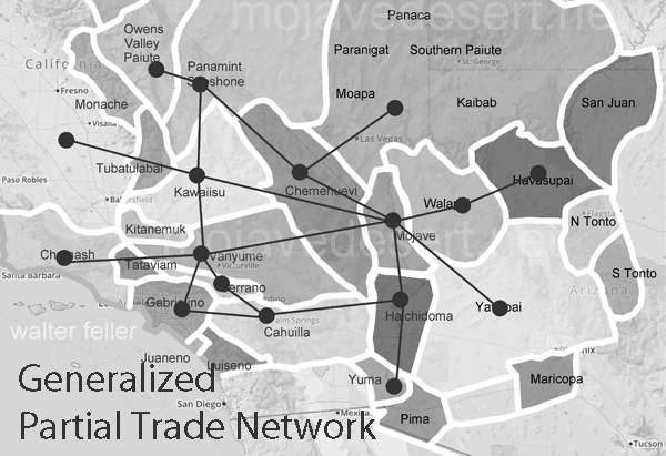
    Pre-1800s: Long before roads or railroads, the Serrano people traveled through Cajon Pass. It was a natural corridor between the Mojave Desert and the valleys to the south — a well-worn trail for trade, gathering, and seasonal movement.

    1776: Spanish explorers, including Father Francisco Garcés, came through the pass. It soon became part of what would later be called the Old Spanish Trail, linking New Mexico to California.

    1830: Trader Antonio Armijo officially led a commercial caravan through Cajon Pass, making it part of the main route for trade between Santa Fe and Los Angeles.

    1848: A few former members of the Mormon Battalion managed to get a wagon through the pass, proving that the steep, rocky route could support overland wagon travel.

    1851: A group of Mormon pioneers, led by Amasa Lyman and Charles Rich, brought dozens of wagons through the pass as they headed to start the settlement of San Bernardino.

    1861: John Brown Sr. built a toll road through Cajon Pass. It made travel easier for wagons and stagecoaches and became the main route connecting Southern California to the desert and beyond.

    1885: The California Southern Railroad completed its line through Cajon Pass, connecting San Bernardino to Barstow. Trains started hauling people, cattle, and freight through the mountains, transforming travel in the region.

    1916: The first paved highway over Cajon Pass was finished, opening the route to automobiles and marking the beginning of modern highway travel in the High Desert.

    1926: Route 66 officially included the road through Cajon Pass. This brought a wave of tourism, roadside businesses, and car culture to the area.

    1969: Interstate 15 was built through the pass, replacing the old highway and making travel faster and more reliable — though not immune to traffic jams and winter weather.

    1989: A tragic train accident occurred when a Southern Pacific freight train lost its brakes and derailed in the pass. The crash caused a deadly pipeline explosion and became one of the worst accidents in the region’s history.

    2016: The Blue Cut Fire tore through Cajon Pass, forcing evacuations and destroying homes. It spread quickly due to high winds and dry brush, reminding everyone just how dangerous fire season can be.

    Present Day: Cajon Pass remains one of the busiest mountain crossings in Southern California. Whether it’s semis on the freeway, Amtrak trains, or long freight hauls, the pass is still doing what it’s done for centuries — carrying people and goods across the mountains.

  • Wrightwood, California

    Historical Timeline

    Pre-1800s: The area that would become Wrightwood was home to the Serrano people, who called themselves the Yuharetum — “people of the pines.” They lived seasonally in the mountains, hunting game, gathering plants, and holding ceremonies in the forested canyons.

    1812: A powerful earthquake, believed to have started near Wrightwood, shook Southern California. The San Juan Capistrano quake damaged missions across the region and left a lasting mark on early California history.

    1854: Isaac Slover, one of the region’s earliest Anglo settlers and bear hunters, was killed by a grizzly near the Wrightwood area. This story added to the frontier reputation of the San Gabriel Mountains.

    1886: Sumner Wright moved to California and eventually discovered the beauty of the Swarthout Valley. He later bought land from prospector Samuel Guffy and started building what would become the town of Wrightwood.

    1924: Facing financial pressure, Sumner Wright subdivided his land into mountain lots and officially formed the village of Wrightwood. It quickly became a getaway for people looking for pine trees and fresh mountain air.

    1926: William Bristol built the Acorn Lodge. This rustic lodge became a social hub for visitors and gave Wrightwood a reputation as a relaxing mountain resort.

    1961: Wrightwood got its first cable TV service — a big deal for a small mountain town that had been pretty isolated for most of its early years.

    1967: The Southern California Gas Company brought natural gas to the area, making life more convenient for full-time residents and visitors alike.

    1970: The opening of Interstate 15 over Cajon Pass made it easier for folks in the Inland Empire and Los Angeles to reach Wrightwood, bringing in more weekenders and winter visitors.

    1973: The road to Crystal Lake reopened after years of closure, reconnecting Wrightwood with the rest of the San Gabriel range and improving access from the south.

    1976: Wrightwood got its first paramedic team — Chuck Blakeslee and Dave Faust — giving the community better emergency medical services in a remote mountain setting.

    2016: The Blue Cut Fire led to mandatory evacuations in Wrightwood. Flames threatened homes and forced thousands of High Desert residents to flee.

    2020: The Bobcat Fire burned through the San Gabriels, and Wrightwood was again on evacuation watch. Wildfire danger had become a growing concern.

    2024: The Bridge Fire hit close to home, forcing the entire town to evacuate. It was a stark reminder of mountain communities’ vulnerability to nature’s unpredictability.

    Present Day: Wrightwood remains a peaceful, pine-covered town in the San Gabriel Mountains. It’s known for skiing, hiking, small-town charm, and neighbors who look out for one another.

  • Adelanto, California

    Historical Timeline

    Pre-1915: Long before it was a city, the land around Adelanto was home to the Serrano people. They lived off the Mojave Desert’s natural resources and followed seasonal cycles along the riverbeds and mountains.

    1915: E.H. Richardson, who invented the Hotpoint electric iron, sold his patent and used the money to buy land in the High Desert. His dream was to build a planned community — a place where World War I veterans suffering from lung conditions could live and heal. He laid out one-acre plots with clean air and sunshine in mind.

    1917: The new settlement got a post office and the name “Adelanto,” which means “progress” in Spanish — a fitting name for a community built on new beginnings.

    1920s–1930s: Adelanto became known for its fruit orchards. Apples, pears, and cider were the pride of the town. But the Great Depression hit hard, and many orchards were torn out and replaced with chicken farms.

    1941: The U.S. government built the Victorville Army Air Field nearby, bringing new jobs and growth to the area. Adelanto quickly became part of the surrounding military community.

    1950: The airfield was renamed George Air Force Base in honor of General Harold H. George. It remained an important base for decades, shaping the town’s economy and identity.

    1970: Adelanto officially incorporated as a city on December 22. At the time, it was the smallest city in San Bernardino County.

    1992: The city adopted a charter, giving it more control over its own affairs.

    2015: Facing financial struggles, Adelanto made headlines by becoming one of the first Southern California cities to allow large-scale medical marijuana cultivation. It was a bold move to bring in revenue and jobs.

    Present Day: Adelanto is still growing and evolving. It’s a mix of military roots, farming history, and modern industry — with people from all walks of life calling it home under the big desert sky.

  • Phelan, California

    Historical Timeline

    1851: Mormon pioneers passed through what is now Phelan on their way to settle San Bernardino. They followed a rugged path across the desert, later known as the Mormon Trail.

    Late 1800s: As stagecoaches traveled between Los Angeles and Las Vegas, Phelan became a stopping point in the wide-open desert. A few ranches and scattered homes dotted the area, helping travelers refuel and rest.

    1916: A post office was established and officially became “Phelan.” It was named after Senator James D. Phelan and his brother John, who had ties to land in the area.

    2008: Residents voted to form the Phelan Piñon Hills Community Services District. This allowed locals to manage their water, parks, and street lighting — helping preserve the area’s quiet, rural character.

    Present Day: Phelan is still an unincorporated town, known for big skies, wide spaces, and a slower pace of life. Tucked between the San Gabriel Mountains and the Mojave Desert, it draws folks who appreciate open land and small-town values.

  • Victorville, California

    Historical Timeline

    Pre-1858: Long before the railroad or highways, the Serrano people — especially the Vanyume band — lived along the Mojave River. They followed the seasons, hunted, gathered, and traded with other Native groups across the desert.

    1858: Army veteran Aaron G. Lane set up a way station called Lane’s Crossing along the Mojave River. It became a lifeline for travelers between San Bernardino and Nevada — a place to rest, water livestock, and pick up supplies.

    1860: Early census records show just ten people living along the Mojave River, including Lane and some Mormon families who had settled there.

    1867: A Mormon settler named Lafayette Meacham built a new wagon road across the Mojave, Stoddard Wells Road. It brought more wagon traffic and helped establish Mormon Crossing just upstream.

    1870s: Heber “Pete” Huntington, a nephew of Brigham Young, opened Huntington Station at Mormon Crossing. That helped turn the area into an early transportation hub in the desert.

    1885: The California Southern Railroad pushed through the area and set up a telegraph station called “Victor,” named after railroad official Jacob Nash Victor. This marked the beginning of a permanent settlement.

    1886: A formal town plan for Victor was laid out — about 200 acres mapped with streets and blocks. The town slowly began to take shape.

    1901: To avoid confusion with Victor, Colorado, the town changed its name to “Victorville.” That same year, the post office made it official.

    1917: The Southwestern Portland Cement Company opened a plant in Victorville. It gave the town an industrial boost, and cement became a major part of the local economy for decades.

    1926: Route 66 was established and passed through town along D Street and Seventh Street, attracting travelers, tourists, and roadside businesses.

    1940: Hollywood came to the desert — screenwriter Herman J. Mankiewicz wrote early drafts of Citizen Kane while staying at the Kemper Campbell Ranch in Victorville.

    1941: The Victorville Army Airfield was built just before the U.S. entered World War II. It trained thousands of pilots and later became George Air Force Base.

    1947: After the war, the base was renamed in honor of Brigadier General Harold Huston George. It remained an active part of the U.S. Air Force for decades.

    1960: Victor Valley College was founded, bringing higher education to the High Desert and helping the region grow.

    1962: Victorville was officially incorporated as a city on September 21. Its population is just over 8,000, and there is still a lot of open space.

    1976: The Roy Rogers and Dale Evans Museum moved from nearby Apple Valley to Victorville, attracting Westerns and cowboy legends fans.

    1992: George Air Force Base was closed during a nationwide military downsizing. Its closure had a big impact, but also freed up space for future development.

    1995: The California Route 66 Museum opened downtown Victorville, preserving the town’s deep connection to the “Mother Road.”

    2003: The Roy Rogers and Dale Evans Museum packed up and moved again to Branson, Missouri.

    2007: Victorville hosted the DARPA Urban Challenge at the former air base — a cutting-edge competition for self-driving vehicles navigating a simulated city.

    Present Day: Victorville has grown into one of the largest cities in the High Desert. It’s a mix of old and new—railroad roots, Route 66 history, a post-war military legacy, and modern-day development all tied into one place.

  • Hesperia, California

    Historical Timeline

    Pre-1800s: Indigenous Serrano people inhabited the Mojave River region, including the Hesperia area.

    1776: Spanish missionary-explorer Father Francisco Garcés travels along the Mojave River near present-day Hesperia.

    1826: Explorer Jedediah Smith follows the Mojave River on his journey west, likely passing through the Hesperia area.

    1848–1850s: During westward expansion, Mormon pioneers traveled through the region on the Mormon Trail.

    1860s–1870s: Ranching and cattle operations began in the High Desert, which was part of old Mexican land grants and early American claims.

    1885: The Atchison, Topeka & Santa Fe Railway laid tracks through the area; the Hesperia Land and Water Company founded Hesperia.

    1887: Hesperia Hotel opens as a luxury resort for travelers and land buyers. A U.S. Post Office is also established.

    1890s–1920s: Agriculture develops — orchards, vineyards, and farms emerge, though water scarcity limits expansion.

    1950s: Route 66 boosts travel through the High Desert, and land speculation increases.

    1954: Hesperia Civic Club is founded to oversee local development.

    1957: Hesperia County Water District is formed to manage local water needs.

    1988: Hesperia officially incorporates as a city on July 1, with a population of around 13,500.

    1990s–2000s: Rapid population growth and suburban development reshape Hesperia into a commuter hub.

    Present Day: Hesperia continues to grow, with a mix of residential, commercial, and community infrastructure serving the Victor Valley.

  • Oro Grande, California

    Historical Timeline

    Pre-1800s: Long before any prospectors showed up, the Mojave River Valley was home to Native people — mostly Serrano and Vanyume — who used the river as a trade route and a life source, traveling and trading across the desert.

    1852: The earliest known burial took place at what would become the Oro Grande Cemetery, making it one of the oldest cemeteries in San Bernardino County. Some believe it also holds the remains of earlier Native residents.

    1858: Army veteran Aaron G. Lane settled along the Mojave River and opened a ranch and store for travelers. This spot, known as Lane’s Crossing, became one of the first American settlements in the region.

    1865: Lane sold his original ranch and moved farther down the river to establish another at Bryman. Still, the old crossing remained a key stop for migrants, traders, and freighters heading east or west.

    1873: A gold discovery on Silver Mountain drew in prospectors and gave birth to the Silver Mountain Mining District. Miners rushed to the area, and a little desert mining boom began.

    1880: More gold and silver were found nearby, and the Red Mountain District was formed. Around this time, the town of Oro Grande got its start, named after the “big gold” — the Oro Grande Mine.

    1881: A post office was opened under the name Halleck, showing that the settlement had grown enough to need regular mail service.

    1887: Limestone was discovered in the hills near town, and small-scale quarrying began. Two kilns were built to turn limestone into lime, laying the groundwork for the cement industry.

    1907: The Riverside Cement Company opened its plant in Oro Grande, and that changed everything. Cement production became the town’s main industry — and much of it went toward building Route 66.

    1926: Route 66 officially rolled through Oro Grande, following the old National Old Trails Highway. The town saw a new wave of business thanks to passing motorists, truckers, and tourists.

    1927: The post office finally changed its name from Halleck to Oro Grande, matching the town’s identity.

    1958: When Interstate 15 was built, it bypassed Oro Grande. With fewer people passing through, many roadside businesses began to fade.

    2023: San Bernardino County Museum designated the Oro Grande Cemetery as a historic site, recognizing its importance and planning for its preservation.

    Present Day: Oro Grande is still a quiet community along the Mojave River. The old cement plant still runs, and roadside landmarks like Elmer’s Bottle Tree Ranch keep Route 66 travelers stopping by. The town wears its history proudly — a mix of mining dreams, industrial grit, and desert charm.

  • Apple Valley, California

    Historical Timeline

    Pre-1776: Long before towns or ranches, the Serrano people lived along the Mojave River, using the land for hunting, gathering, and seasonal migration.

    1776: Spanish missionary Francisco Garcés passed through the area following the river, likely making contact with local Serrano groups.

    1826: Explorer Jedediah Smith made his way through the High Desert on his westward journey, becoming one of the first Americans to cross into California overland.

    1849–1859: Thousands of travelers — trappers, miners, and Mormon settlers — moved along the Mojave River Trail. It became a busy corridor of westward movement.

    1860: Silas Cox built what’s believed to be the first settler’s cabin in what would become Apple Valley.

    1861: A rough wagon road was cut through the valley, helping new settlers move goods and livestock through the region.

    Late 1800s: Ranching took hold. Paiute families moved into the area, and a few hardy settlers ran cattle across the desert range.

    Early 1900s: The name “Apple Valley” started appearing, possibly linked to the Appleton Land Company. Ursula M. Poates is sometimes credited with popularizing it.

    1920s: Apple orchards lined the riverbanks. The valley earned a reputation for producing crisp, sweet apples — for a time, it lived up to its name.

    1926: Nolie and Lela Murray opened Murray’s Dude Ranch — one of the few vacation spots in the West that welcomed Black guests during segregation.

    1930s: The orchards began to fade. The cost of irrigation and the harsh economy of the Great Depression made farming harder to sustain.

    1946: Newton T. Bass and Bernard “Bud” Westlund launched Apple Valley Ranchos, marketing the area as a sunny, relaxed alternative to city life.

    1948: The Apple Valley Inn opened on Thanksgiving Day. A swanky hotel, it was built to impress land buyers and draw in celebrities.

    1949: The first official post office opened, making the name “Apple Valley” permanent.

    1950s: Growth kicked into high gear. Schools, churches, banks, and a golf course popped up. Apple Valley became a small but thriving community.

    1965: Roy Rogers and Dale Evans moved to town. Roy leased the Apple Valley Inn and put his name on it, giving the town a little Hollywood sparkle.

    1967: The Roy Rogers-Dale Evans Museum opened, full of cowboy hats, saddles, and movie memorabilia. Fans flocked to see it.

    1976: The museum moved to nearby Victorville to reach more visitors.

    1988: Apple Valley became an official town on November 14. By then, over 41,000 people called it home.

    2003: The museum packed up again, this time heading to Branson, Missouri, chasing a bigger audience.

    2009: Sadly, the Branson museum closed. But the legacy of Roy and Dale still lives on in Apple Valley.

    Present Day: Apple Valley continues to grow, with new homes and businesses rising up where orchards once stood. But it still holds onto its Western roots, desert charm, and small-town spirit.

  • Lake Thompson

    The Vanished Ice Age Lake Beneath Antelope Valley

    Long before the roar of jet engines echoed from Edwards Air Force Base and the Antelope Valley became known for aerospace and arid winds, it was home to a massive Ice Age lake—Lake Thompson. This now-vanished body of water tells a deep story about climate, earth movements, and the life that once thrived in a very different Mojave.

    A Desert That Was Once a Basin of Water

    Lake Thompson formed during the late Pleistocene epoch, when glaciers covered parts of North America and climates across the West were colder and wetter. The Antelope Valley, surrounded by the San Gabriel, San Bernardino, and Tehachapi mountains, collected snowmelt and rainwater in a broad, low-lying depression. Back then, this area was a “closed basin”—a natural bowl with no outlet to the sea. So, as precipitation increased and evaporation stayed low, water began to rise and pool, eventually forming a lake roughly 367 square miles in size.

    At its fullest, Lake Thompson was nearly 230 feet deep and stretched across Rogers Lake, Rosamond Lake, and Buckhorn Lake. These are the dry, cracked lakebeds we see today—remnants of that long-lost water body.

    A Sedimentary Record of Changing Times

    The floor of Lake Thompson became a repository for everything the surrounding land and water brought in: silt, clay, sand, and organic matter. These sediments settled in quiet layers, building up year after year. Over time, these layers became a rich record of the lake’s rise and fall.

    Core samples taken from the basin tell the story. Some show fine clays deposited during long, deep lake periods, while others reveal coarser, sandy material left behind as the lake dried out during warmer interludes. Layers of carbonate crust—deposited when water levels fell and minerals became concentrated—mark periods of evaporation and shrinking shorelines. Organic material embedded in these layers has been radiocarbon dated to track climate shifts over the last 30,000 years.

    Shaped by Faults, Not Just Floods

    The creation of Lake Thompson wasn’t just about water. It was also about land and how it moved. The Antelope Valley sits along major tectonic features: the San Andreas Fault to the south and the Garlock Fault to the north. Movements along these faults shaped the land over millions of years, causing earth blocks to shift and drop, forming depressions that trapped water.

    These tectonic movements, combined with subsidence (the gradual sinking of the Earth’s surface), created the basin where Lake Thompson formed. The region’s geology continues to shift today, though the Big Ice Age lakes era has passed.

    Fossils and Evidence of a Living Landscape

    Lake Thompson didn’t just collect water—it supported life, lots of it. Fossil finds in the lake’s ancient sediments include bones from mammoths, extinct camels, horses, and bison—megafauna that roamed the lake’s edges during the Ice Age. Their presence tells us this was not a lifeless salt flat but a rich, green wetland environment teeming with grasslands and water sources.

    Tiny fossils matter too. Shells from freshwater snails, fish bones, and ostracods (tiny crustaceans) help scientists reconstruct the lake’s ecosystem. These fossils point to freshwater conditions during much of the lake’s life, followed by increasingly salty and alkaline phases as it dried out.

    A Lake Fades Into Memory

    By around 8,000 years ago, Lake Thompson had mostly dried up. The shift into the warmer, drier Holocene epoch reduced rainfall, boosted evaporation, and turned wetlands into playas. What was once a vibrant Ice Age lake became the flat, empty spaces we see today—windblown, sunbaked, and often forgotten.

    Today, the legacy of Lake Thompson is still visible if you know where to look. Rogers and Rosamond dry lakes, now used for aircraft and rocket testing, still bear the perfectly flat imprint of deep water long gone. The ancient shorelines are marked in subtle terraces along the valley’s edges. Sediment layers hold secrets of shifting climates, and buried bones remind us that this was once a much wilder place.


    Conclusion: A Geologic Memory Written in Dry Earth

    Lake Thompson isn’t just a vanished lake. It shows how Earth’s climate, geography, and ecosystems work together. It’s a story about how even a desert was once a haven for giant beasts and flowing water. And though the lake is gone, its imprint—etched into the land and buried in the soil—remains evidence for all who want to read the story of California’s ancient inland sea.

  • Murray’s Ranch

    Joe Louis, best known as a heavyweight boxing champion, also had a love for the Wild West. He was one of the regulars at Murray’s Dude Ranch in Apple Valley, California, just outside Victorville, on the edge of the Mojave Desert.

    Heavyweight boxing champion Joe Louis

    Billed as “the only Negro Dude Ranch in the World,” Murray’s was more than a retreat—it was a symbol of freedom and dignity at a time when segregation kept Black families out of many public spaces.

    The ranch was founded in 1922 by Nolie and Lela Murray, a Black couple from Los Angeles. They originally opened it as a group home for underprivileged youth. However, by the 1930s, facing financial strain and inspired by the growing popularity of dude ranches, they transformed it into a guest ranch that welcomed African American travelers from across the country.

    Listed in the Negro Motorist Green Book, Murray’s Ranch offered cabins, a swimming pool, tennis courts, and riding stables. It became a favorite hangout for prominent Black figures like Joe Louis, actress Hattie McDaniel, dancer Bill “Bojangles” Robinson, and singer Lena Horne. Western actor Herb Jeffries even filmed several “all-Black cast” cowboy movies there, including Harlem on the Prairie and The Bronze Buckaroo.

    Pearl Bailey

    After Lela died in 1949, Nolie continued to run the ranch until the mid-1950s, when singer Pearl Bailey and her husband, drummer Louis Bellson, bought a portion of it. They renamed it “The Lazy B” and used it as their private retreat for nearly a decade. Over the following decades, the ranch gradually fell into disrepair, and in 1988, the last remaining buildings were destroyed during a training exercise conducted by the Apple Valley Fire Department.

    Though nothing remains of the physical site today, Murray’s Dude Ranch lives on in memory—a rare and powerful example of Black leisure, community, and self-determination in a time and place where those things were far too rare.

    1922 – Nolie and Lela Murray, a Black couple from Los Angeles, establish the property in Apple Valley as a group home for African American youth.

    Early 1930s – Facing financial strain and inspired by the popularity of dude ranches, the Murrays convert the home into a guest ranch for Black travelers.

    Mid-1930s – Murray’s Dude Ranch is advertised as “the only Negro Dude Ranch in the World.”

    1937 – Joe Louis visits the ranch, bringing national attention. His visit helps establish the ranch as a hotspot for prominent African American entertainers and athletes.

    Late 1930s – Entertainers like Hattie McDaniel, Bill “Bojangles” Robinson, Lena Horne, and Herb Jeffries become regular visitors. Jeffries films all-Black Westerns here, including Harlem on the Prairie (1937) and The Bronze Buckaroo (1939).

    1941 – The ranch is listed in the Negro Motorist Green Book, identifying it as a safe and welcoming destination during segregation.

    1949 – Lela Murray passes away. Nolie Murray continues running the ranch.

    Mid-1950s – Pearl Bailey and her husband Louis Bellson purchase part of the property, rename it “The Lazy B,” and use it as a private retreat for about nine years.

    1970s–1980s – The ranch declines and is largely abandoned.

    1988 – The Apple Valley Fire Department intentionally burns down the remaining structures during a training exercise.

  • A History of Yucca Loma Ranch

    Yucca Loma Ranch was more than just a patch of land out in Apple Valley — it was a dream brought to life by Dr. Catherine Boynton, a spiritual healer from Colorado, who settled there in 1919. She wasn’t chasing fame or fortune. What she wanted was to create a peaceful place where people, especially those battling illnesses like tuberculosis, could find healing and hope under the desert sun. And that’s exactly what she did.

    Her ranch became a serene desert retreat, nestled among the yucca trees, where people could rest, recover, and reconnect with nature, with themselves, and sometimes even with the stars. Word got out, and before long, Hollywood types were slipping away from the spotlight to stay there. Stories say Clark Gable and Carole Lombard found comfort there, especially after tragedy struck.

    The ranch also drew quiet thinkers, like actor David Manners. He wasn’t chasing the next big role — instead, he built a small home on the ranch and turned to writing. His reflections on desert life appeared in a column called Under the Old Yucca Tree — fitting for a man who found inspiration in the stillness.

    After Dr. Boynton passed in 1949, the ranch changed hands. Newton T. Bass, one of Apple Valley’s key developers, lived there until a fire destroyed the main house. Slowly, the land was split up, and new homes replaced the old structures. Today, not much is left of the original ranch. But the stories—of healing, of stardom, of desert peace—still echo across the valley.

    1919 – Dr. Catherine Boynton, a spiritual healer from Colorado Springs, establishes Yucca Loma Ranch in Apple Valley as a health retreat for individuals suffering from illnesses such as tuberculosis.

    1920s–1930s – The ranch becomes renowned as a haven for spiritual healing and quiet reflection. Notable visitors include naturalist Ernest Thompson Seton.

    1940s–1950s – Yucca Loma evolves into a popular guest ranch among Hollywood celebrities. Rumors suggest that Clark Gable and Carole Lombard visited for privacy and to seek healing.

    1940s – Actor David Manners builds a home on the property with Boynton’s permission. He writes novels and a local newspaper column while living there.

    1949 – Dr. Boynton passes away. Ownership of the ranch eventually transfers to developer Newton T. Bass.

    1950s–1960s – Bass resides at the ranch until it is destroyed by fire. The surrounding land is later subdivided for residential development.

    Present Day – Most of the original ranch structures are gone, but their legacy remains part of Apple Valley’s cultural and historical fabric.

  • History of Apple Valley, California


    With Timeline of Events

    Apple Valley, located in California’s High Desert, has a deep and varied history shaped by Native peoples, pioneers, developers, and Hollywood legends.

    Before settlers arrived, Native American tribes including the Serrano, Paiute, and Mojave lived along the Mojave River. These Indigenous communities thrived on its seasonal flows and the resources it provided. In 1776, Spanish missionary Francisco Garcés passed through the area, blazing trails that later became vital travel routes for westward migration. Between 1849 and 1859, more than 13,000 emigrants, traders, and miners traveled the Mojave River Trail through what would become Apple Valley.

    The name “Apple Valley” was coined in the 1890s by Ursula Poates, who remarked on the apple trees growing modestly along the river. Though apple farming peaked in the 1920s with award-winning orchards, it declined during the Great Depression due to high irrigation costs and competition from other regions.

    In 1910, Dr. Harris Garcelon homesteaded 160 acres of land and founded what would become Jess Ranch. Originally promoted as a retreat for individuals with asthma and tuberculosis, the ranch eventually served as a sanatorium for World War I veterans. After plans for a resort failed during the Depression, Garcelon’s nephew, Stoddard Jess, purchased the property in 1932. Jess, in partnership with neighbor Gay Lewis, turned it into one of the West’s largest integrated turkey ranches. Later, with ample water rights, they added trout farming and opened public fishing lakes under the “Royal Coachman” brand. By the 1980s, the land transitioned into the residential and retirement community known as Jess Ranch.

    The transformation of Apple Valley accelerated in 1946 when developers Newton T. Bass and Bud Westlund established the Apple Valley Ranchos Land Development Company. Their goal was to create a model desert community. In 1948, they opened the Apple Valley Inn, a luxury resort that attracted celebrities such as Bob Hope, Marilyn Monroe, and John Wayne. In 1965, Roy Rogers leased the inn and added his name to it, creating a Western-themed attraction complete with horse stables and outdoor cookouts.

    Just above the inn, Newton Bass built the Hilltop House in 1957. This modernist residence, designed to impress visiting investors, featured floor-to-ceiling windows, boulder outcrops in the living room, and panoramic desert views. Though damaged by fire in 1967 and neglected for decades, it stood as an icon of Apple Valley’s early vision until its demolition in 2022. A public overlook is now planned for the site.

    Other notable landmarks include Dead Man’s Point, a granite outcrop between Apple Valley and Lucerne Valley, named for local legends and known for its dramatic views. It was used as a filming location in the 1950s and once hosted a small Old West-themed attraction. Bell Mountain, northeast of town, rises to nearly 3,900 feet. Settled in the early 1900s, it now draws hikers seeking a challenging climb and wide desert views.

    Apple Valley was incorporated as an official town on November 14, 1988. Today, it blends desert serenity with a colorful legacy of ranchers, developers, celebrities, and homesteaders—all of whom helped shape this uniquely American desert community.


    Timeline of Apple Valley History

    • 1849–1859 – Mojave River Trail sees heavy pioneer travel.
    • 1890s – Ursula Poates names the area “Apple Valley.”
    • 1910 – Dr. Garcelon establishes a health-focused homestead (Jess Ranch).
    • 1912 – Homesteaders begin settling the Bell Mountain area.
    • 1932 – Stoddard Jess buys the ranch; turkey farming begins.
    • 1946 – Apple Valley Ranchos Land Development Company is founded.
    • 1948 – Apple Valley Inn opens to attract investors and celebrities.
    • 1955 – Dead Man’s Point used as a movie location.
    • 1957 – Hilltop House constructed by Newton T. Bass.
    • 1965 – Roy Rogers leases and rebrands the Apple Valley Inn.
    • 1977 – Jess Ranch ceases turkey operations.
    • 1986 – Residential development begins at Jess Ranch.
    • 1988 – Town of Apple Valley officially incorporates (November 14).
    • 1994 – Jess Ranch trout farm closes.
    • 2003 – Restoration efforts begin on Apple Valley Inn.
    • 2022 – Hilltop House is demolished; the site is slated for a scenic overlook.

  • Preserving History in the Face of Censorship

    Imagine trying to solve a mystery, but someone keeps hiding the clues. That’s what happens when people “scrub” history—removing or changing facts to tell a different story. Sometimes it’s done quietly, like deleting photos from an exhibit. Other times, it’s more dramatic, like governments hiding entire documents or removing digital records. Either way, it’s dangerous. When history gets altered, we lose the truth. And without truth, we can’t learn, grow, or hold anyone accountable.

    To stop this from happening, there are rules and responsibilities in place—laws, ethics, and professional promises that help protect the past. Around the world, organizations like UNESCO and the International Council on Archives (ICA) work hard to make sure history stays accurate and available. They’ve created global guidelines, like the Universal Declaration on Archives, which says that everyone has a right to trustworthy information about the past. This declaration encourages governments to adopt strong laws and archival policies that protect authenticity and public access.

    UNESCO also leads programs like the Memory of the World, which works to preserve important historical documents and make sure people everywhere can learn from them. Its 2003 Charter on the Preservation of Digital Heritage and its 2015 Recommendation on Documentary Heritage both stress that preserving history isn’t just about keeping paper records safe—it’s also about protecting digital materials and making sure they aren’t erased or changed.

    National laws back up these ideas. In the U.S., the Federal Records Act and the Presidential Records Act make it illegal to destroy or tamper with federal documents without permission. These laws ensure that records of important events, especially those involving elected officials, are kept intact and available for the public. Other countries, like the UK, have similar laws requiring the transfer and protection of government documents.

    Besides legal protections, professionals who work in archives, libraries, and museums follow strict ethical codes. The Society of American Archivists (SAA) and the International Council on Archives (ICA) both have rules that require archivists to keep records accurate, unaltered, and properly cared for. Their job isn’t to rewrite history—it’s to protect it. Librarians, under the American Library Association (ALA), also promise to provide access to all points of view on historical and current issues, even if the material is controversial. And museum workers under the International Council of Museums (ICOM) Code of Ethics are expected to present historical content honestly and without bias, based on careful research.

    These values apply just as strongly to digital records. Since electronic files can be changed so easily, archivists use special tools like checksums and metadata to make sure digital documents stay original. They also document every action they take, so future users know exactly what happened to a record over time. Organizations like the Internet Archive also help by saving copies of websites, even when others try to delete or censor them.

    When violations happen, they don’t go unnoticed. In 2020, the U.S. National Archives got caught altering a photo of the 2017 Women’s March by blurring some of the protest signs. This caused an outcry from archivists and historians. The Society of American Archivists called it “fraudulent and deceptive,” and the National Archives quickly admitted the mistake, removed the altered image, and promised it wouldn’t happen again. This example shows that the system can work—when people speak up, institutions can be held accountable.

    Around the world, archivists and librarians often serve as protectors of truth. In some countries, they’ve hidden records during times of war or government repression, saving them for a time when they could be shared safely. In others, they resist pressure to remove books or exhibits that challenge the status quo. Their ethics give them the courage to preserve even the most uncomfortable truths.

    As history becomes more digital, these protections matter more than ever. Digital records are fragile—a single click can delete them, and search engines can hide them. That’s why laws and ethics are evolving to include new technologies. UNESCO’s digital heritage charter calls for international cooperation to preserve digital history, and professional groups are creating new standards to keep online records safe and reliable.

    In the end, protecting history isn’t just about old papers and artifacts. It’s about defending our right to know what really happened. It’s about making sure future generations have the full story—not a cleaned-up version that leaves out the hard parts. By following laws, upholding ethics, and staying vigilant, we can make sure the past stays honest, complete, and available to all.

    Because if we let the truth slip away, what kind of future will we build on it?

    And within this mission to preserve history, we must also protect the stories that don’t always come from official records—the stories passed down through word of mouth, memory, and tradition. Folklore may not be written in government archives or preserved in legal documents, but it holds the emotional truth of a people. These tales, songs, sayings, and legends help communities explain their past, share their values, and make sense of the world. Folklore captures what it felt like to live through an event, not just what happened. It adds depth, meaning, and personal connection to the facts found in formal records.

    When folklore is lost, we don’t just lose stories; we lose a way of thinking and understanding that belongs to a particular group of people. Folklore reflects the humor, the fears, the struggles, and the hopes of a culture. That’s why efforts to preserve oral histories, local legends, and traditional knowledge are just as important as keeping official archives intact. Archivists, historians, and community members must work together to record and respect folklore alongside the facts. Because often, folklore fills in the gaps that the official story leaves out.

    Truth isn’t always tidy. Sometimes it lives in the cracks between documents, whispered across generations. By defending folklore as a vital part of our historical record, we honor the full spectrum of human experience—not just what was written down, but what was remembered and retold.

  • Bad Men from Bodie

    Here are some of the most infamous “Bad Men from Bodie” — real characters who helped give the town its rowdy, violent reputation in the late 1800s:

    1. James StuartStagecoach Robber & Lynching Victim
    Stuart was caught robbing a stagecoach and brought to Bodie for trial. But locals weren’t in the mood for legal delays. In 1881, a mob dragged him out of jail and hanged him from a telegraph pole on Main Street. This was frontier justice, Bodie-style.

    2. Tom TreanorKiller in a Saloon Shootout
    Treanor was known for his hot temper and quick trigger. He got into an argument over a card game in a saloon and opened fire. He killed his opponent, but the townsfolk weren’t exactly shocked. In Bodie, that kind of trouble was practically expected.

    3. William “Red” IrwinGunman with a Reputation
    Red Irwin shot a man during a poker game, claiming self-defense. Witnesses disagreed. But with the help of skilled lawyers (possibly like Pat Reddy), he avoided serious punishment. He strutted Bodie’s streets afterward, daring anyone to challenge him.

    4. Joe “Fat Jack” ClarkNotorious Brawler
    Fat Jack was a miner with fists like anvils and a bad attitude to match. Known for knocking out men in a single punch, he was feared in town and banned from several saloons. He reportedly killed a man during a bar brawl but was never convicted.

    5. Lottie Johl (Honorable Mention)Not a “bad man,” but a tragic figure
    Lottie was the wife of Jacob Johl, a saloon owner. She had a rough reputation herself, sometimes unfairly. After her death, she was buried in the town cemetery, but rumors claimed some townsfolk had her body moved due to prejudice. Her story adds a darker layer to Bodie’s social world.

    These individuals — some criminals, some just violent men in a violent time — helped cement Bodie’s image as a place where life was cheap, and justice was often swift and deadly.

  • Bodie’s Notoriety

    Timeline of major violent events and notorious moments in Bodie, California’s wild history — a town so lawless it earned a reputation as one of the roughest mining camps in the West:

    1876 – Bodie’s Boom Begins
    The Standard Mine strikes gold. Prospectors flood in, and Bodie transforms from a quiet camp into a booming town — and with it comes gambling, saloons, opium dens, and gunslingers.

    1879 – Peak Population, Peak Violence
    Bodie hits its peak with around 7,000–10,000 residents. That year alone, it’s said there were 30+ murders, many tied to gambling disputes and drunken shootouts. The phrase “Bad Man from Bodie” enters widespread use.

    1879 – Tom Treanor Kills a Man in a Saloon
    After a heated argument during a card game, Treanor guns down another miner in a crowded bar. He was arrested but later released after a murky trial. The town shrugs it off — just another night in Bodie.

    1880 – Gunfight on Main Street
    A broad daylight gunfight erupts between rival gamblers. Two men are killed, and several bystanders are wounded. This kind of event is common enough that locals don’t even bother locking their doors — they’re used to chaos.

    1881 – James Stuart Lynched by a Mob
    Caught robbing a stagecoach, Stuart is jailed in Bodie. That night, a group of vigilantes breaks in and hangs him from a telegraph pole. His body dangled for hours — a message to other would-be criminals.

    1882 – Red Irwin Walks Free After Killing a Man
    “Red” Irwin shoots another gambler in the back during a dispute. Witnesses testify, but the case is dismissed on a technicality. Irwin boasts about it in saloons afterward, reinforcing Bodie’s anything-goes culture.

    1883 – Deputy Sheriff Shot in Line of Duty
    Deputy John Kelly is killed while trying to break up a bar fight. His murder is never solved. By this point, even lawmen hesitate to enforce order in Bodie.

    1884 – Town Begins to Decline
    Mines starts to dry up. Many “bad men” drift elsewhere. But Bodie’s violent legend is cemented, passed down through newspapers, dime novels, and the stories of old-timers.

    1915 – Bodie Officially a Ghost Town
    The post office closes. Fires, neglect, and time erase most of the town — but its violent, freewheeling legacy lives on.

  • Opening the “Bullion Trail” (1860s–1880s)

    Remi Nadeau and the Cerro Gordo Freight Road: Opening the “Bullion Trail” (1860s–1880s)

    Origins of the Cerro Gordo Freight Road

    The story of Remi Nadeau’s freight road begins with the rich silver strikes at Cerro Gordo in the late 1860s. Cerro Gordo (“Fat Hill” in Spanish) was a remote mining camp high in the Inyo Mountains of eastern California, overlooking Owens Lake. Rich veins of silver-lead ore were discovered there around 1866–1868, attracting investors like Mortimer Belshaw and Victor Beaudry. These mine owners faced an urgent challenge: transport heavy silver bullion (smelted silver and lead ingots) from the isolated mountaintop to the distant markets and refiners in Los Angeles. At first, only primitive trails existed. Belshaw financed and built a steep toll road down the mountain – the “Yellow Grade Road,” named for the yellowish rock it cut through – to facilitate moving ore out. Even with that local road, the journey from Cerro Gordo to Los Angeles was an arduous three-week trek by wagon. In December 1868, Belshaw and Beaudry hired a skilled freighter, Remi Nadeau, to haul their bullion to Los Angeles. Nadeau dispatched 32 mule-team wagons that carried about $50,000 of silver and lead each day (in 1868 dollars) down the Yellow Grade and across the desert.” Cerro Gordo’s mines often produced twice as much ore as freighters could move, creating a bottleneck. The situation demanded a more robust freight system.” The solution would be a dedicated freight road – eventually dubbed the “Bullion Trail” – and Nadeau’s freighting empire would make it a reality.

    Remi Nadeau: From Miller to Freight Magnate

    Remi Nadeau was an unlikely figure to dominate desert transportation. He emigrated to the United States in Quebec, Canada, in 1821. Nadeau worked as a miller in New England and the Midwest. In 1861, he crossed the plains to Salt Lake City, building several mills before finally moving to Los Angeles. Sensing opportunity in the underdeveloped economy of Southern California, Nadeau borrowed a few hundred dollars from Prudent Beaudry (a Los Angeles real estate man and brother of Victor) to buy wagons and mule teams, launching himself into the freighting business. His first contracts involved hauling goods on a 700-mile route between Los Angeles and Salt Lake City, a round trip that took 35 days. This routine remained profitable until the transcontinental railroad reached Utah in 1868, when it undercut wagon freight.

    Nadeau then turned his attention to the booming mining camps of the Mojave Desert and Eastern Sierra, especially Cerro Gordo. In 1868–69, he began hauling silver bullion from Cerro Gordo to Los Angeles. Nadeau introduced the use of long mule teams – often 14 to 20 – to pull heavy bullion over rough terrain. He is credited as the first in California to use 20-mule teams on such a scale. By 1869, Nadeau had become the leading freighter in Southern California. The Cerro Gordo silver trade became the heart of Los Angeles’s economy in the 1870s, making up about a quarter of the city’s total exports. Los Angeles was still a sleepy town, but Nadeau’s mule trains carrying bullion to San Pedro created a wealth stream that fueled local growth.

    Developing the “Bullion Trail” – A Road from Cerro Gordo to San Pedro

    As freight operations expanded, the 230-mile route to the harbor necessitated improved infrastructure. In 1873, the Los Angeles Chamber of Commerce and Cerro Gordo mine owners struck a deal with Nadeau to create a regular freight line. Nadeau agreed that shippers invest $150,000 to improve the route. The company used these funds to construct stations and watering stops, as well as improve roads across the desert and mountains. The organizers formally established the Cerro Gordo Freighting Company that same year. The road from Cerro Gordo to San Pedro became known as the “Bullion Trail” or “Nadeau Road.” This road was not a paved road but a network of tracks and stations that provided consistent bullion transport. Nadeau commissioned 80 heavy wagons, each capable of hauling about four tons. They were pulled by teams of 16–20 mules, making a sight over a hundred feet long. The company established a round-trip schedule of about 22 days, with one-day stretches between stations. At any time, 56 wagons were on the road while others were loaded or maintained. Nadeau’s operation soon had 100 mule teams, the first organized, large-scale freight line in the California desert.

    The Route and Major Stops Along the Way

    The freight route began at Cerro Gordo, descending the treacherous Yellow Grade Road to the Owens Valley floor. Wagons often had their rear wheels “rough locked” or chained to skids to control the descent. From there, bullion was sometimes ferried across Owens Lake by the steamer Bessie Brady to Cartago. Overland wagons would reconverge at Olancha and head south across the Mojave. Freighters established stations every 15–25 miles, including Coyote Holes, Red Rock Canyon, Forks-of-the-Road, Cow Holes, and Barrel Springs. These stops offered water, feed, corrals, and shelter. Red Rock Canyon provided a scenic route through the El Paso Range. Forks-of-the-Road likely sat at a major junction, and Cow Holes was a known desert watering spot. Wagons eventually entered Soledad Canyon, following the Santa Clara River past Lang Station, an important water stop. From there, they moved through Newhall Pass via Beale’s Cut into the San Fernando Valley. They followed San Fernando Road into Los Angeles. The final stretch went another 20 miles south to San Pedro Harbor. Bullion was refined and loaded onto ships bound for San Francisco and beyond.

    Trials and Challenges on the Road

    The Bullion Trail was grueling. Summer heat, winter snow, and rough terrain all posed threats. Freighters often had to haul water to the stations, where it was crucial. Teamsters frequently drove at night to avoid the heat. Sandstorms and steep grades were constant hazards. To descend slopes like Yellow Grade, drivers locked wheels and used skids or logs as brakes. Accidents were rare, a sign of the drivers’ skill. Bandits were another risk. Notorious outlaw Tiburcio Vásquez and his lieutenant Cleovaro Chavez robbed travelers, including a holdup at Coyote Holes in 1874. Teamsters traveled with arms, and some convoys used guards. Competition from rival freighters also arose, but Nadeau’s system was well-run and dominant. The operation required hundreds of mules, skilled blacksmithing, and careful logistics. Round trips took 22 days, ensuring a constant flow of bullion and supplies. Despite the hardships, Nadeau’s line earned a reputation for reliability — reportedly, freighters never lost a load of silver in transit.

    Impact on the Mining Economy and Los Angeles

    Nadeau’s freight line allowed Cerro Gordo’s mines to operate at full capacity. In the early 1870s, the mine produced up to $50,000 in daily bullion. Return trips carried goods and supplies to the miners. At its peak, Cerro Gordo had a population of around 4,000–4,700. Nadeau’s road tied the remote mining camp to the California economy. In Los Angeles, the impact was huge. With fewer than 10,000 people in 1870, the city benefited from the influx of silver. The Cerro Gordo trade accounted for approximately 25% of the city’s export revenue. Local smelters, banks, and merchants thrived, and San Pedro Harbor saw growing shipments. Nadeau himself became one of the city’s wealthiest men. In 1886, he built the Nadeau Hotel, Los Angeles’s first luxury high-rise. He also invested in land, farming, and early industry. The freight road’s success helped promote investment in infrastructure and railroads. By 1876, the Southern Pacific Railroad reached Los Angeles, roughly paralleling the Bullion Trail. In the early 1880s, the Carson & Colorado Railroad reached Keeler near Cerro Gordo, replacing the mule teams. Nadeau had anticipated the change and moved on to other freighting ventures in Arizona and Nevada. His freight company dissolved by 1882.

    Decline and Legacy of Nadeau’s Freighting Enterprise

    With railroads expanding and silver output declining, the era of mule-team freight faded. Still, Nadeau’s achievement in running a reliable freight line across 230 miles of desert was remarkable. Over 13 years, his wagons moved enormous amounts of freight and bullion. He helped jump-start Los Angeles’s transformation into a commercial hub. Nadeau died in 1887, remembered as a self-made man whose enterprise bridged the desert and tied remote mining to coastal commerce. Early motorists utilized parts of the old road, and wagon ruts marked the route in certain areas.

    The Bullion Trail had a permanent impact on Southern California’s economy and geography. Modern highways, such as US 395 and SR 14, follow much of his pioneering route. His legacy lives on in place names, historical markers, and memories of when mules and grit built the roads that carried silver to the sea.

  • Railroad Across the Mojave

    Initially, negotiations between the California Southern and the Southern Pacific over securing a route from Needles to the Pacific Coast proved difficult. The Southern Pacific, which held effective control over the only existing line across the Mojave Desert, was in no hurry to assist a potential rival. The Southern Pacific’s leadership, accustomed to monopolizing rail access into and across California, viewed any arrangement that would aid an eastern competitor with deep suspicion.

    Faced with obstruction and unreasonable demands, the California Southern and the Atlantic and Pacific Railroads—both closely tied to eastern capital—announced a bold plan. If the Southern Pacific would not cooperate on reasonable terms, they declared they would jointly undertake the construction of an entirely new and independent railroad across the desert. This proposed line would have paralleled the Southern Pacific’s existing track but remained free of its influence, offering the first serious threat to the Southern Pacific’s dominance over desert transportation.

    The announcement was not a mere bluff. Surveys were conducted, routes were studied, and eastern investors, eager to establish a competitive foothold in the California market, were prepared to finance the new line. The specter of competition alarmed the Southern Pacific. It recognized that the construction of a rival road could undermine its existing investments, dilute its control, and establish a permanent eastern presence in southern California on terms not of its choosing.

    California Southern Railroad construction in Cajon Pass

    To avoid a costly and unpredictable conflict, the Southern Pacific made a calculated decision. In October 1884, it agreed to sell the line between Needles and Mojave—a route built initially by its construction arm, the Pacific Improvement Company. By doing so, the Southern Pacific sidestepped a potential rival and still profited from its investment in the desert.

    The transfer was a turning point. With control of the Needles-Mojave line secured, the California Southern could at last resume construction in earnest, repairing flood damage and completing its transcontinental link. By late 1885, trains could run from San Diego to Barstow, and by 1886, the California Southern itself had been acquired by the Atchison, Topeka, and Santa Fe Railway, effectively sealing the eastern invasion into California’s rail market.

    California Southern and Atlantic and Pacific Railroad: Timeline with Notes (1880–1886)

    • October 12, 1880Charter Granted
      The California Southern Railroad Company is chartered to build a line from San Diego to San Bernardino, opening a new southern route to inland California.
    • May 23, 1881Extension Planned
      The California Southern Extension Company is chartered to extend the line northeast to connect with the Atlantic and Pacific Railroad, originally aiming for a point about 80 miles from San Bernardino.
    • August 1882Reaches Colton
      Track completed to Colton; the line begins to make inroads into Southern Pacific territory.
    • September 13, 1883Main Line Opened
      Full operation begins between San Diego and San Bernardino. California Southern faces strong opposition from the Southern Pacific almost immediately.
    • Winter 1883–1884Severe Flood Damage
      Torrential rains devastate Temecula Canyon. Thirty miles of track are destroyed, bridges are washed away, and ties are seen floating far out to sea. The company faces ruin unless major repairs are undertaken.
    • Early 1884Strategic Setback
      Southern Pacific, exercising influence over the Atlantic and Pacific Railroad, forces the eastern connection to be built at Needles on the Colorado River—far beyond the original plan—meaning California Southern must now cross 300 miles of mountain and desert.
    • Mid-1884Threat of Independent Construction
      In response, the California Southern and Atlantic and Pacific announce that if necessary, they will build a completely independent railroad across the desert to avoid using Southern Pacific lines. Surveys are ordered, and eastern backers prepare financing.
    • October 1884Southern Pacific Relents
      Rather than risk parallel competition, the Southern Pacific agrees to sell the Needles-to-Mojave line to the California Southern Railroad. The Pacific Improvement Company, an entity under the control of Southern Pacific, had built the track.
    • November 1885Line Repaired and Completed
      After extensive repairs and new construction, the California Southern opens through service from San Diego to Barstow, near the junction of the Atlantic and Pacific at Needles.
    • October 1886Control Transferred to Santa Fe
      The California Southern is formally absorbed into the Atchison, Topeka, and Santa Fe Railway system, becoming part of a major transcontinental route and ending Southern Pacific’s near-monopoly over southern California rail traffic.

    The struggles and ultimate success of the California Southern Railroad marked a turning point in the history of Southern California. By securing a route independent of the Southern Pacific’s control, the California Southern, under the wing of the Atchison, Topeka, and Santa Fe, opened the region to competition, lower freight rates, and new waves of settlement and development.

    No longer isolated or captive to a single powerful railroad, San Diego and the inland valleys could now connect directly to the markets of the East. The great deserts and mountains that had once seemed impassable barriers became corridors of commerce and migration. In many ways, the hard-fought efforts of the California Southern and its allies helped lay the groundwork for the explosive growth of Southern California that would follow in the decades to come. It was a victory not only of rails and capital, but of determination against monopoly and geographic hardship.


  • Vandalism in the Mojave

    Vandalism in the Mojave Desert is a sad and serious problem — one that strikes at the heart of both the land’s natural beauty and its long history. For generations, the desert has been a place where time seems to stand still, preserving ancient petroglyphs, pioneer landmarks, and fragile ecosystems. But in recent decades, careless or malicious acts have left scars that, in some cases, can never be repaired.

    Here are a few examples of what has been happening:

    • Graffiti on Rocks and Historic Sites: Ancient petroglyph sites, such as those at Cima Cinder Cones or in the foothills around Ridgecrest, have been defaced with modern spray paint. Some of these rock carvings are thousands of years old, left by Native American cultures who passed through the desert. Once modern graffiti covers them, the original markings can be almost impossible to recover without damaging the rock itself.
    • Destruction of Joshua Trees: Joshua trees, iconic symbols of the Mojave, are often cut down, burned, or knocked over by vandals or irresponsible visitors. These trees take centuries to mature, and once destroyed, they are lost for generations.
    • Abuse of Historic Structures: Old cabins, mining equipment, and stage stops — like those scattered across places such as Panamint Valley, the Old Government Road, or Route 66 — have been broken into, stripped of artifacts, or shot up for target practice. These relics tell the story of the Westward movement, ranching, mining, and early desert survival. Without proper protection and respect, these places vanish.
    • Off-Road Vehicle Damage: Although not always intentional, off-trail driving can damage delicate desert crusts, crush ancient artifacts hidden just beneath the surface, and destroy habitats for rare animals, such as the desert tortoise. Some riders even create unauthorized “tagging” spots with tire tracks or leave behind trash and broken bottles.
    • Campfire and Trash Damage: Illegal campfires scorch desert floors, and piles of garbage left behind by careless visitors mar otherwise pristine spots. Old tires, cans, and broken furniture — all of it doesn’t just look bad; it alters soil chemistry and attracts scavengers that disrupt the natural balance.

    In the past, a person’s word and respect for the land meant something — it was understood that you leave no trace. To take from or harm the desert was seen as a mark of poor character, not adventure.

    Many local groups today, such as High Desert Keepers, Friends of the Mojave Road, the Mojave Desert Land Trust, and various historical societies, work diligently to restore damaged sites, educate visitors, and promote the traditional values of stewardship and personal responsibility.

    It is a reminder that the desert may seem rugged and unchanging, but it is fragile, and when a piece of its story is lost to vandalism, it is lost forever.