Early reports of mineralization and occasional prospecting activity in the Resting Springs Range and southern Amargosa area.
1877
William D. and Robert D. Brown discover the Noonday and Gunsight mines, uncovering high-grade silver-lead ore that draws attention to the Resting Springs Mining District.
1878
Jonas Osborne incorporated the Los Angeles Mining and Smelting Company after acquiring claims, including the Noonday and Gunsight mines. Backed by Los Angeles investors, he builds a smelter and begins ore processing in the Tecopa region.
1880s
Borate minerals, including colemanite and ulexite, are identified in the Amargosa region, setting the stage for major borax mining ventures.
1904
F.M. “Borax” Smith incorporates the Tonopah & Tidewater Railroad (T&T) to connect the borate fields of southeastern California and Nevada with transcontinental rail networks at Ludlow, CA.
1905
Development begins at the Lila C. Mine in the Amargosa Desert, a major source of colemanite. The mine becomes central to Smith’s borax empire.
1906
The Biddy McCarthy Mine is located east of Tecopa, initially developed for silver and lead, but later became known for its production of talc.
1907
The Tonopah & Tidewater Railroad reaches Tecopa and Death Valley Junction, revolutionizing freight and passenger access in the remote desert mining district.
1909
The Tecopa Railroad Company is incorporated to build a short-line spur connecting the Noonday mines to the T&T at Death Valley Junction.
1910
The Tecopa Railroad begins ore haulage, efficiently moving silver-lead ore from the mines around Tecopa to the main T&T line for shipment to smelters.
1916
First talc claims are filed in the Southern Amargosa Range, particularly in the Ibex Hills and Eagle Mountain area. The region begins shifting toward talc production.
1918
Ore haulage declines on the Tecopa Railroad as major silver-lead mines begin to play out. Following postwar economic shifts and reduced output, the railroad entered a period of gradual decline, although it remained in limited use into the 1920s.
1920s
The Biddy McCarthy Mine reaches peak production as a talc operation. With silver and lead in decline, talc becomes the district’s primary mineral commodity.
1930s
U.S. Gypsum and other firms expand talc mining near Tecopa. Industrial demand for talc supports continued use of legacy mining infrastructure and revitalizes some sites.
1938
The Tecopa Railroad is dismantled. With mining activity diminished and trucking on the rise, the short line is no longer economically viable. Its removal marks the end of an era in desert mining logistics.
A hundred years ago—around 1925—the Mojave Desert was a land of stark contrast: wild and wide open, yet dotted with signs of human ambition. Here’s what it was like back then:
1. Railroads Ruled the Desert: Steam engines crisscrossed the Mojave, linking mining camps, military posts, and towns. The Tonopah & Tidewater, Santa Fe, and Union Pacific lines were lifelines, hauling ore, supplies, and people. Sidings and water stops, such as Bagdad, Kelso, and Ludlow, bustled with activity.
2. Mining Booms Still Echoed: Many boomtowns had already peaked—places like Calico, Rhyolite, and Panamint City were fading—but borax, gold, and silver mining continued. Boron’s giant deposit was discovered just around that time (1925), setting the stage for future industrial mining.
3. Rugged Settlements and Homesteads: Scattered homesteaders, prospectors, and ranchers tried to carve out a living. Water was precious, and so were shade and company. Windmills spun over hand-dug wells, and mail came by mule or train.
4. Roads Were Primitive: Highways were mostly graded dirt or gravel. Route 66 had just been designated that year (1925), but paving was still spotty. Motorists faced long, isolated stretches with little more than a gas pump and maybe a café every 40 miles or so.
5. Indigenous Displacement Ongoing: Mojave, Chemehuevi, Paiute, and other Native peoples still lived in the region, though most had been pushed to reservations or marginalized communities. Traditional knowledge of the land persisted, but the pressures of assimilation and loss of territory were heavy.
6. Forts Fading, but Military Still Present: The old frontier forts like Fort Mojave and Camp Cady were history by then, but the Army still trained in the desert and surveyed for future uses. The military interest in desert space would only grow in coming decades.
7. Harsh but Beautiful: You’d find desert bighorn, kit foxes, roadrunners, and thriving groves of Joshua trees and creosote. Spring wildflowers carpeted the land after rare rains. Flash floods, dust storms, and brutal heat shaped daily life—and survival.
8. The Desert as Frontier Myth: Writers, photographers, and curious travelers were beginning to romanticize the Mojave as a mysterious American frontier. The desert was both feared and admired—a place where outlaws vanished and fortunes were still whispered about.
In essence, the Mojave of 1925 was a tough, raw land with threads of industry, survival, and myth pulling through the scrub and stone. It wasn’t the end of the world—but you could see it from there.
Thirty years ago, around 1995, the Mojave Desert was a quieter, less-developed place compared to today, but the seeds of change were already taking root. Here’s a snapshot of what it was like back then:
1. Less Development, More Open Space: Many desert towns, such as Victorville, Hesperia, and Palmdale, were still transitioning from small high desert communities into bedroom suburbs for Los Angeles. You could drive long stretches without spotting a gas station or subdivision.
2. Military and Mining Still Strong: Fort Irwin, Edwards Air Force Base, and China Lake were in full swing, fueling local economies. Some small-scale mining was still active, especially for gold and borates, though not nearly at the scale of earlier decades.
3. Old Highways Still in Use: I-40 had bypassed Route 66 in the late ’80s, but by 1995, old stretches through places like Amboy and Ludlow were still drivable and saw occasional travelers chasing nostalgia.
4. Fewer Tourists, Less Regulation: Joshua Tree hadn’t yet become a national park (that happened in 1994), so it still had more of a remote, rustic feel. Off-roading was looser, backcountry camping was less regulated, and you didn’t need a timed entry to watch the sunrise.
5. Fading Ghost Towns: Places like Rhyolite, Ballarat, and Goldfield were in a quieter state of decay—few tourists, fewer interpretive signs—just you, the wind, and the ruins.
6. The Environment: The desert was showing early signs of environmental stress—growing urban sprawl, invasive species like tamarisk spreading along washes, and increasing off-road vehicle damage. But wildflower seasons still dazzled when the rains came right, and bighorn sheep still roamed less-disturbed ranges.
7. Culturally: You’d find more old-timers living out of trailers, caretaking abandoned mining camps, or running desert curiosity shops. The new wave of artists, climbers, and Instagrammers hadn’t yet arrived in full force.
In short, the Mojave of 30 years ago felt emptier, rougher around the edges, and more like the “last frontier” than it does today. A place still living in its own time, even as the modern world started to catch up.
M. Penn Phillips was a bold and ambitious real estate developer who believed in turning wide-open land, often desert or high-country wilderness, into thriving communities. Starting in the 1920s and continuing into the 1960s, he spearheaded numerous developments, primarily in California’s deserts, mountains, and inland valleys. Some projects found their footing; others fell short. But all bear the stamp of Phillips’ flair for promotion and his dream of reshaping the American West.
One of his earliest ventures was Frazier Mountain Park, launched in 1924 in the mountains of Kern County. Phillips built a lodge, created five artificial lakes, and sold hundreds of cabin lots to folks looking for a cool-weather retreat. The area is still known today as Frazier Park.
In the late 1920s, he set his sights on Nevada, carving up large tracts of desert outside Las Vegas and marketing them to people hoping to stake a claim near what would eventually become a booming city. These Las Vegas tracts were speculative—sold well before the Strip or Hoover Dam existed—but laid the groundwork for future development.
Around the same time, Phillips was busy acquiring tens of thousands of acres along the Colorado River, which straddles the Arizona-California border. Though no town came from it, this was classic land-banking—buying cheap desert land and selling it to dreamers, retirees, and speculators.
After World War II, as Southern California experienced rapid growth, Phillips focused on the Antelope Valley, subdividing desert land near Palmdale and Lancaster. He marketed these parcels to veterans and working families, banking on the growing aerospace industry nearby to drive settlement.
By the early 1950s, he’d moved into the Victor Valley, laying out Mountain View Acres near Victorville. These were one-acre lots with few frills—just raw land and a chance to build your own home on the cheap. That do-it-yourself spirit carried over into Apple Valley and beyond, where Phillips sold off more desert tracts with promises of clean air, open skies, and low prices.
He didn’t stop there. He offered land across the Mojave, from Barstow to Newberry Springs, always touting affordability and opportunity. Not every buyer got rich, but enough people came to plant the seeds of small desert communities.
Phillips’ biggest swing came in Hesperia. Starting in 1954, he acquired over 23,000 acres and developed a comprehensive city plan, featuring homes, businesses, a man-made lake, a golf course, and his signature “U-Finish Homes.” These were houses built with finished exteriors but unfinished interiors—buyers were expected to finish the drywall and floors themselves. It was cheaper that way, and it attracted a wave of do-it-yourselfers. Hesperia eventually became a city, though much of Phillips’ vision was scaled back or scrapped due to infrastructure problems and unrealistic timelines.
Then came Salton City, a bold plan on the western shore of the Salton Sea. Between 1958 and the early 1960s, Phillips laid out thousands of lots and built streets, a yacht club, a hotel, and even a golf course. Sales were explosive—millions of dollars’ worth of lots sold in just one weekend. But the sea turned brackish, the infrastructure crumbled, and the dream fell apart. Today, Salton City is a shadow of what was promised, with paved streets stretching out into the desert, most still awaiting homes that never materialized.
He even sold land in the Big Bear Lake area, offering cabin sites in the mountain pines. These were some of his more modest and enduring projects, quietly blending into an already popular resort region.
From mountain lakes to desert shores, Penn Phillips left behind a scattered legacy of ambition and overreach. Some of his projects sparked the creation of real towns. Others remain little more than maps and memories. But taken together, they paint a vivid picture of one man’s attempt to reinvent the West, one parcel at a time.
List of Penn Phillips Projectsin High Desert & Mountains
Frazier Mountain Park – Frazier Park, CA (1924) Mountain resort community with lakes, lodge, and recreational amenities.
Las Vegas Tracts – Las Vegas Basin, NV (1927) Early speculative desert subdivisions before major city growth.
Colorado River Basin Lands – AZ/CA border (1929–1932) Large-scale desert land acquisition and resale, not tied to any one town.
Palmdale & Lancaster Tracts – Antelope Valley, CA (Late 1940s) Ranch and residential lots near growing aerospace centers.
Victorville – Mountain View Acres – Victorville, CA (Early 1950s) 1-acre home lots, early desert subdivision still populated today.
Apple Valley Subdivisions – Apple Valley, CA (Late 1940s–1950s) Home and ranch parcels sold in conjunction with other desert ventures.
Barstow & Newberry Springs – San Bernardino County, CA (Late 1940s–1950s) Remote residential and farm lots; many remain undeveloped.
Hesperia – Hesperia, CA (1954–1960s) Master-planned community featuring “U-Finish Homes,” a lake, and a resort vision.
Salton City (Salton Riviera) – Salton Sea, CA (1958–1960s) Massive planned resort town with marina, golf course, and yacht club – later failed.
Big Bear Lake Area Tracts – San Bernardino Mountains, CA (1940s–1950s) Cabin and mountain home sites in a growing resort region.
Maximilian Franz Otto Strobel, better known as Max Strobel, was a Bavarian immigrant, surveyor, and land developer who played a significant yet quiet role in shaping Southern California in the late 1800s. He is remembered today as Anaheim’s first mayor and a driving force behind the early movement to create what would eventually become Orange County. But his ambitions stretched even farther—into oil, railroads, colonization schemes, and one particularly bold plan to develop a vast stretch of desert land that later became Hesperia.
Born in 1826 in Bavaria, Strobel was caught up in the political unrest of the 1848 revolutions in Europe. Like many young idealists of his time, he joined in the fighting and had to flee once the revolution failed. He made his way to the United States in 1851, landing in New York and quickly finding work as a surveyor for the U.S. government.
His skills earned him a spot on John C. Frémont’s 1853 expedition to find a transcontinental railroad route across the Rockies. Strobel survived bitter winter conditions and rough terrain to help complete the survey. From there, he briefly joined the infamous filibusterer William Walker in Nicaragua, an adventure that ended in chaos and a narrow escape.
By the late 1850s, Strobel had made his way to California, where he worked on Frémont’s Mariposa Estate before jumping into early oil exploration in Los Angeles County. He drilled in Brea Canyon and helped manage one of the area’s first petroleum ventures—well ahead of its time. Around 1865, he settled in Anaheim, a small German farming colony, and quickly became involved in civic life.
In 1870, Max Strobel became Anaheim’s first mayor. With a vision for local self-rule, he spearheaded a campaign to break away from Los Angeles County and form a new county, which he hoped would be called Anaheim County. He even launched a newspaper, The People’s Advocate, to rally support. The effort failed, but it laid the groundwork for what would eventually become Orange County in 1889.
Around the same time, Strobel participated in a large land deal in the upper Mojave Desert. Acting as an agent for a syndicate, he helped purchase about 50,000 acres near the Mojave River—an area that would one day become Hesperia. The land was chosen with the hope that a major railroad line would soon pass through, boosting land value and attracting settlers. But the railroad didn’t arrive for nearly 15 years. Investors lost patience, and the project was scrapped.
The land later passed into the hands of a German temperance colony—a group hoping to establish a dry, orderly settlement in contrast to the wine-making culture of Anaheim. While this effort didn’t take root, it paved the way for the eventual founding of Hesperia during the land boom of the 1880s, when the Chaffey brothers and their partners attempted again to build a model town. This time, the railroad had arrived, but lasting success was still slow to come.
Meanwhile, Strobel had turned to other ventures. In 1872, he traveled to London to broker the sale of Santa Catalina Island and other California properties to British investors. The deal was close to closing when Strobel died suddenly in his London hotel room in early 1873. The exact cause was never made public, and his death remains something of a mystery.
Strobel died without fanfare, and for decades his name slipped into obscurity. It wasn’t until the late 20th century that local historians in Anaheim began to rediscover his contributions. Today, Max Strobel is remembered as a bold, restless figure—part dreamer, part doer—whose plans didn’t always work out, but who helped lay the foundations of Southern California as we know it.
Sources: Historical accounts from the Los Angeles Times, Anaheim local history archives, and Mojave Desert regional histories have been used in compiling this biography. Notable references include Richard Buffum’s “Father of Orange County Loses Some Mystery” (LA Times, Feb. 22, 1987)latimes.com, the Anaheim Public Library’s records on Strobel (via J. Rubio’s 2014 research)anaheimhistory.blogspot.com, and the Mojave Desert historical report “Once Upon a Desert” (1976) detailing the Hesperia land scheme digital-desert.com, scvhistory.com, among other sources as cited above. Each provides insight into the fascinating, multifaceted life of Max Otto Strobel.
The Hesperia Land and Water Company was established during Southern California’s great land boom of the mid-1880s. In 1885, Dr. Joseph P. Widney – a prominent Los Angeles figure and former president of USC – joined with his brother, Judge Robert M. Widney, and the Chaffey brothers (George and William Chaffey, renowned for developing Ontario, California) to form the company. That year, Joseph Widney acquired approximately 35,000 acres of Mojave Desert land (previously assembled by Max Strobel in 1869–1870) and laid out a townsite for a new colony. They named the settlement “Hesperia,” derived from a Greek term meaning “western land,” which reflected its location at the western edge of the desert.
The town plan featured broad streets – reportedly laid out in a grid with unusually wide rights-of-way, lined with shade trees – as part of an envisioned modern desert utopia. The initial tract included most of Township 4 North and parts of 5 North, Range 4 West, spanning the Mojave River’s west mesa and upper valley.
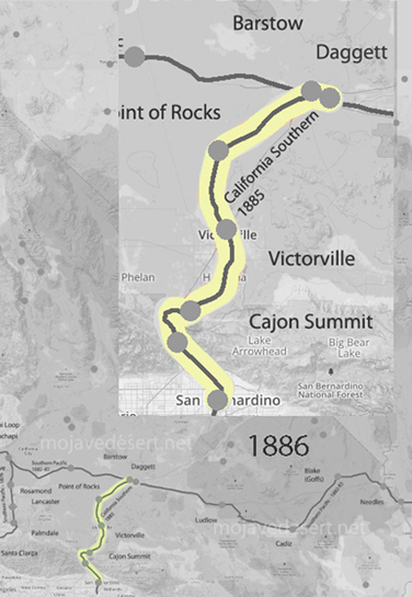
Early on, the developers sold about 2,000 acres (including a strategic dam site at the Upper Mojave Narrows) to help start the adjacent railroad town of Victor (Victorville), while reserving the mesa lands for Hesperia’s development. By late 1885 the California Southern Railroad (Santa Fe) had completed its line up through the Cajon Pass, and a small depot at Hesperia was in service, positioning the area for incoming settlers and tourists.
Development of the Hesperia Irrigation System and Water Rights Securing a reliable water supply was crucial to the colony’s agricultural ambitions. In early 1886, the company staked an ambitious claim to the flows of Deep Creek (the east fork of the Mojave River). Following frontier water law, Hesperia Land & Water placed a stone monument on the creek in 1886 to give public notice of its appropriation: an enormous 5,000 miner’s inches of water (per minute) to be diverted for use on the Hesperia lands. This volume, equivalent to around 125 cubic feet per second, was touted as enough water for tens of thousands of people, far anticipating the needs of the few settlers then present. The claim, which accounted for virtually all of Deep Creek’s flow, was intended to ensure Hesperia’s future growth and establish priority over downstream users. Indeed, the filing for 5,000 miner’s inches in 1886 would become the basis of Hesperia’s water rights for decades, and the company later asserted that it had continuously used this water each year for 20 years – thereby “proving up” its rights. The initial water works, begun in 1887, were hailed as a marvel of engineering: the so-called Hesperia Ditch and pipeline system. Engineers excavated a diversion channel in solid rock high in Deep Creek Canyon and built a diversion dam and intake above the Forks (where Deep Creek joins the West Fork Mojave). From there, water was carried about four miles in an open, concrete-lined canal along the canyon wall. At the Mojave River, the flow dropped into an inverted siphon – a 14-inch diameter riveted steel pipeline that ran 1¼ miles under the riverbed and up the opposite side to the Hesperia Mesa. The pipeline then extended several more miles across the mesa, totaling five miles of pipe, and emptied into an earthen reservoir near today’s Lime Street (this reservoir had a capacity of about 58 acre-feet). By 1888, the Hesperia irrigation system was operational, capable of delivering roughly 40 second-feet of water to the mesa. The colony used the water to plant orchards (notably apples) and other crops; at peak in the late 1880s, about 1,000 acres of farmland in Hesperia were under irrigation from this system.
Securing the water was not without conflict. Almost as soon as Hesperia’s plans became known, farmers and landowners downstream along the Mojave River (in Victorville, Oro Grande, and beyond) objected strenuously to this large upstream diversion. They feared Hesperia’s ditch would diminish the Mojave’s flow that sustained their ranches. Legal challenges and threats were raised even “before a spade was turned”, but Robert Widney and his company pressed ahead regardless. The Hesperia canal was completed and water was flowing by 1888, despite the protests. However, the dispute over Deep Creek water rights simmered and would resurface in later years. Hesperia’s appropriation was recorded with San Bernardino County and stood as a senior claim. Still, competing schemes would test it, most dramatically the Arrowhead Reservoir project in the early 1900s (discussed below) that aimed to impound the headwaters for use outside the desert.
Town Promotion, the Hesperia Hotel, and Railroad Connections
The Hesperia Land and Water Company undertook energetic promotional efforts to attract buyers and settlers to their desert colony. As a centerpiece of the development, the company constructed the grand Hesperia Hotel in 1887. This was a three-story, 36-room hotel built of adobe bricks (freighted in from Oro Grande), then painted a distinctive red. The hotel was intended to serve as both comfortable lodging for prospective land purchasers and a resort destination in its own right, capitalizing on the desert climate and scenery. Promotional literature described Hesperia as a healthful, idyllic community where irrigation would “make the desert bloom.” Wide, tree-lined streets and a planned town center were mapped out, and the availability of ample water for homes and farms was heavily advertised. Excursion trips were likely arranged, as the new railroad line made Hesperia accessible from Los Angeles and San Bernardino. Indeed, by 1885, the California Southern Railroad (part of Santa Fe) had established a station at Hesperia, which became a regular stop along the line through the Victor Valley. This rail connection was crucial in bringing in investors during the boom. The company also laid out a small business district near the station and hotel, anticipating an influx of commerce. By 1890, Hesperia boasted not only the hotel but also a general store, a post office, and a schoolhouse to serve the nascent community. All of these improvements were in place just as Southern California’s speculative land frenzy was reaching its zenith. For a brief moment, Hesperia appeared poised to become a thriving agricultural colony and tourist retreat in the high desert.
Collapse in the 1887–1888 Land Bust
Hesperia’s boom was short-lived. In 1887, the inflated real estate market across Southern California abruptly crashed, bringing land sales to a standstill. The grand plans of the Hesperia Land and Water Company began unraveling almost immediately after the costly infrastructure was built. By mid-1888 – barely six months after the hotel and other facilities were finished – the regional land boom went “bust,” and demand for Hesperia lots evaporated. Many of the investors and would-be settlers simply never arrived, leaving the new town with a handful of residents and far more lots than people. The company, having expended enormous capital on land, waterworks, and the hotel, found itself unable to generate revenue. A general economic depression particularly affected land development companies in the late 1880s, and Hesperia was no exception. The ambitious irrigation system that had been Hesperia’s pride became a financial liability, expensive to maintain with too few customers paying for water. In the 1890s, cultivated acreage shrank significantly as orchards and fields were abandoned due to a lack of farmers. The Hesperia Hotel, once a showpiece, largely stood empty; it survived into the 20th century but never fulfilled its original purpose as a luxury resort. Contemporary accounts began referring to Hesperia as a “ghost town” – a fate sealed by the collapse of the 1880s land boom. The Hesperia Land and Water Company itself slid toward insolvency. It made no further progress on expanding irrigation and could not finance crucial improvements like a storage reservoir to capture winter flows (needed to ensure summer water supply). Periodic flash floods even damaged the pipeline – the steel siphon under the Mojave River was washed out several times around the turn of the century. By 1909, the system had temporarily ceased delivering water to Hesperia. Essentially, the Grand Desert Colony project lay dormant and failed as a private venture, awaiting reorganization.
James G. Howland’s Role in Hesperia’s Early History
One name often mentioned in local reminiscences of early Hesperia is James G. Howland. Although not listed among the original incorporators, Howland appears to have been a key leader on the ground during the colony’s formative years. Contemporary reports and later historical sketches suggest that James G. Howland acted in a managerial or executive capacity for the Hesperia Land and Water Company, overseeing daily operations and promotion of the townsite. Some accounts refer to Howland as effectively leading the company’s efforts in Hesperia – for example, directing the sales campaign and perhaps supervising the construction of the infrastructure. Dr. Joseph Widney and the Chaffeys provided the vision and capital, but it was figures like Howland who carried out the practical development work. Howland’s background is less documented in published sources; he may have been an associate of the Chaffeys or an experienced land agent hired to manage the Hesperia project. By local lore, he was the “resident booster” for the town, responsible for guiding tours of the property and extolling the new colony’s potential. Archival information on Howland is sparse, but it’s known that he remained involved at least until the collapse of 1888. After the land bust, Howland fades from the record – it’s unclear whether he stayed on the desert or moved to other ventures. Nonetheless, his early leadership in Hesperia earned him a spot in the town’s historical memory. Modern historical summaries credit Howland as having “led” the Hesperia Land and Water Co.’s promotional push, even if his name did not appear in official founder lists. He is an example of the many 19th-century development promoters whose work was critical to these boomtown schemes, even if later overshadowed by the marquee investors. (Further biographical details on James G. Howland have proven elusive in available archives, suggesting that dedicated research in regional archives or newspapers might be needed to flesh out his story.)
Reorganization under the Appleton Land, Water and Power Company (1911)
After two decades of stagnation, Hesperia got a second chance in the early 20th century. In 1911, the assets of the defunct Hesperia Land and Water Co. were purchased and restructured by a new investment group under the name Appleton Land, Water and Power Company. This company was essentially the successor to the original colony enterprise, formed with an authorized capital stock of $300,000 (similar to the original). The Appleton group – reportedly led by P.D. Hatch of Los Angeles – aimed to revive Hesperia’s agricultural potential and make the faltering water system viable. Upon taking over in 1911, Appleton immediately set about rehabilitating and upgrading the infrastructure. They relined the old intake canal from Deep Creek. They replaced the unreliable siphon pipeline with a brand new, larger-capacity steel pipe in a better location under the Mojave River. Specifically, approximately four miles of new 30-inch riveted steel pipe were laid, including a redesigned inverted siphon that crosses the river – a substantial improvement over the old 14-inch line.
Portions of the original pipeline leading to Hesperia were retained, but much of the system was modernized. A concrete diversion dam (20 feet long) with proper headgates was built on Deep Creek to control and measure the flow into the conduit. Through these efforts, Appleton increased the canal’s capacity to an estimated 40 cubic feet per second and aimed to bring more land under irrigation. To separate utility operations from land sales, the Hesperia Water Company was formed in 1915 as a subsidiary public service entity. With a $40,000 capital investment, the Hesperia Water Co. took over the distribution of water to local users, leasing the water rights and facilities from Appleton, and came under the regulation of the state Railroad Commission as a public utility. This move “divorced” the water service from the colonization business, recognizing that the two required different management. By 1916, however, irrigation under the revived system was still modest – only about 310 acres (90 in orchards and 220 in alfalfa and corn) were being watered. Appleton L. W. & P. Co. controlled roughly 20,000 acres of land (the bulk of the original holdings), with approximately 18,000 acres of that accessible by the new mainline pipe; however, they had not yet succeeded in attracting large numbers of settlers to purchase and farm the land. The new company continued to supply water to the neighboring town of Victorville. Notably, the Victorville water system (serving that community by the river) was owned and operated by Appleton as of the late 1910s. Despite the improvements, Hesperia’s growth continued to be slow. The Appleton company’s strategy eventually shifted more toward long-term land holding and leasing water, rather than immediate large-scale colonization. Nonetheless, the 1911 reorganization preserved Hesperia’s water rights and infrastructure for the future, preventing the project from collapsing entirely.
Legal Disputes over Deep Creek Water (Arrowhead Reservoir Company Conflict)
Hesperia’s water rights claims soon faced a serious challenge from outside interests. In the late 1890s and early 1900s, a consortium of Los Angeles and San Bernardino investors formed the Arrowhead Reservoir Company, with the intention of damming Deep Creek (and other headwaters in the San Bernardino Mountains) to divert water southward to the growing cities of the San Bernardino Valley. This plan directly threatened the Mojave Desert communities because it would have siphoned off the source of the Mojave River. Starting around 1902, a prolonged legal and political battle unfolded between Arrowhead Reservoir Co. and virtually all Mojave River water users, prominently including the Hesperia Land and Water Co. and its successors. W.A. Field, who was president of Hesperia Land & Water around this time, led the fight on behalf of the desert interests. Hesperia’s position was that its prior appropriation and use of Deep Creek (dating back to 1886) gave it a superior right that would be harmed if Arrowhead built its dam. In formal filings and court actions, Field and the company argued that the Arrowhead project would “deplete, obstruct or eradicate” the natural flow of water into the Mojave River, thereby violating Hesperia’s vested rights and devastating the farms that depended on that water. The Hesperia company asserted control over some 33,000 acres along the river and marshaled evidence of its water claims: notably a filing for 1,000,000 miner’s inches of flood flow on both forks of the Mojave (an enormous claim made in the early 1900s to preempt Arrowhead). Hesperia pointed out that its claim predated Arrowhead’s by over two years, and furthermore, that for 20 years it had continuously taken about 5,000 miner’s inches from Deep Creek for use on the Hesperia mesa, establishing an “inviolable right” through continued beneficial use. In 1906, while Arrowhead Reservoir Co. began constructing a dam at Little Bear Valley (what would become Lake Arrowhead), Hesperia’s allies (including other ranchers and a group of midwestern investors who had bought up downstream rights) prepared to build a dam of their own in Victor Valley to capture water for local use. A flurry of lawsuits ensued. In 1909, numerous riparian landowners in the Mojave River basin – bolstered by Hesperia’s claims – filed suit to enjoin Arrowhead from diverting the mountain waters out of the basin. These cases dragged on for years. Ultimately, the desert interests prevailed: Arrowhead’s scheme to export Mojave water was halted. By the time Arrowhead’s dam (Lake Arrowhead) was completed in 1922, it was for recreational and local use only; the courts had prohibited the company from sending water south to San Bernardino. The precious Deep Creek flows continued down into the Mojave River, securing the water supply for Hesperia and its neighbors. This protracted legal victory was significant – it protected the Victor Valley’s lifeline and affirmed the priority of Hesperia’s 19th-century water appropriation. Decades later, those same rights would be recognized in comprehensive water adjudications for the Mojave Desert.
Long-Term Influence on Hesperia and the Victor Valley Though the Hesperia Land and Water Company’s original venture did not immediately blossom into the thriving colony its founders envisioned, it left a lasting imprint on the High Desert’s development. The town of Hesperia itself survived in diminished form – a “ghost that refuses to die,” as one historian later put it – thanks largely to the water infrastructure and land surveys put in place in the 1880s. The wide streets laid out by Widney and the Chaffeys became the skeleton of the Hesperia community that would finally grow many decades later. Most importantly, the company’s early establishment of water rights on Deep Creek ensured that Hesperia and surrounding areas had a secured share of water for future use. This proved crucial for the valley’s long-term viability. The successful defense against the Arrowhead Reservoir diversion preserved the Mojave River flows for local agriculture and settlement through the 20th century. Communities like Victorville and Apple Valley thus continued to have access to water, allowing them to expand. In fact, the Hesperia project indirectly spurred development elsewhere in the Victor Valley: for example, in the 1890s some of Hesperia’s unused land was planted in vineyards, producing raisins and wine that briefly gave the Hesperia name a positive reputation. The idea of desert land reclamation persisted – Appleton Land & Water Co.’s efforts in the 1910s to grow apples and alfalfa in Hesperia were an outgrowth of the original dream. While those early orchards never reached large scale, they demonstrated the desert’s agricultural potential under irrigation.
In the long run, the greatest impact of the Hesperia Land and Water Company was to anchor a settlement at the top of the Cajon Pass that could later be revived. Indeed, after World War II, the Victor Valley experienced a new land boom. In 1954, the remaining 35,000-acre Hesperia ranch (still essentially the same tract the Widneys had assembled) was sold to a development syndicate, the Hesperia Land Development Company. This mid-20th century effort, building on the old townsite and water system, finally succeeded in sparking substantial growth. By the late 1950s, Hesperia was marketing itself as an affordable residential community for Southern Californians, and population began rising. The city of Hesperia incorporated in 1988, a milestone that would have been impossible without the foundations laid by the 1885 company. The influence of that original company is also evident in the region’s infrastructure: the general route of today’s water deliveries in Hesperia traces back to the Deep Creek diversion engineered in the 1880s. The Victor Valley’s agricultural and urban development throughout the 20th century – from ranches to suburbs – was enabled by the water rights and pioneering spirit of those early entrepreneurs. In sum, the Hesperia Land and Water Company’s ambitious attempt to “make the desert bloom” did not prosper on the first try, but it set in motion the land acquisitions, legal rights, and vision of a desert community that eventually became reality. Hesperia and its neighboring High Desert towns owe a considerable debt to that 1880s boom-era venture for establishing their place on the map and securing the water that sustains them to this day.
Sources: Historical records and analyses were drawn from local history publications, engineering reports, and archival documents, including the State of California Dept. of Engineering Bulletin No. 5 (1918) on Mojave River irrigation, Edmund Jaeger’s “The Ghost that Refuses to Die” (Desert Magazine, Aug. 1954), San Bernardino County historical chronicles, and contemporary accounts and legal filings regarding water rights (e.g. Van Slyke v. Arrowhead Reservoir Co., 1909). Newspaper archives and local museum materials corroborate the roles of key figures like the Widneys, Chaffey brothers, and James G. Howland in Hesperia’s founding. The city of Hesperia’s own historical overview and marker texts were also consulted for confirmation of dates and figures.
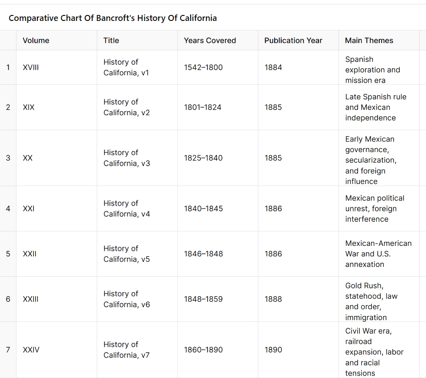
Comparative Chart of Bancroft’s History of California
Introduction and Usage for the Chart:
This chart provides a structured overview of the seven-volume series on California written by Hubert Howe Bancroft as part of his History of the Pacific States of North America, published between 1884 and 1890 by The History Company. Each entry summarizes the key historical themes covered in that specific volume, giving readers a chronological and thematic guide from the first European contact in 1542 through California’s political, social, and economic transformation up to 1890.
Usage:
Historical Reference: Quickly identify which volume covers a specific era or subject, such as the mission system, Mexican secularization, or the Gold Rush, before delving into the primary source.
Curriculum Planning: Useful for educators or researchers designing units around specific periods (e.g., Spanish colonization, Mexican California, U.S. annexation, or statehood).
Topical Exploration: Locate the volume that best discusses themes like land ownership, Native relations, immigration policy, political revolutions, or railroad monopolies.
Comparative Study: Observe how governance, economy, and cultural landscapes shifted across three regimes—Spanish, Mexican, and American—over nearly 350 years.
This chart serves as a compact gateway to Bancroft’s monumental historical work, facilitating both in-depth scholarship and broad contextual understanding of California’s complex past.
Mark Raymond Harrington was an American archaeologist who played a significant role in uncovering what became known as the “Lost City” in southern Nevada. The site, appropriately named Pueblo Grande de Nevada, comprises a series of ancient Native American settlements located along the Muddy River in the Moapa Valley. These sites were occupied from roughly 300 B.C. to around A.D. 1150.
In 1924, two brothers, John and Fay Perkins, discovered ruins and reported them to Nevada’s governor, James Scrugham. The governor contacted Harrington, who was associated with the Museum of the American Indian in New York. Harrington led the first major excavations, which began that same year.
The remains included pit houses and later adobe pueblos—some of which were over 100 rooms in size—built by the ancestral Puebloan people. The press began referring to the site as the “Lost City,” although Harrington preferred the formal name.
In the 1930s, the construction of Hoover Dam posed a threat to the area as the rising waters of Lake Mead would soon flood many of the sites. Harrington, with support from the National Park Service and the Civilian Conservation Corps, organized salvage excavations to recover as much material as possible before the site was inundated.
In 1935, the Lost City Museum (then known as the Boulder Dam Park Museum) was constructed near Overton, Nevada, to preserve and display artifacts from the site. The museum still operates today.
Harrington’s work was among the first to demonstrate the western extent of the Puebloan cultural world and remains a foundational chapter in the archaeology of the Mojave and Southwest deserts.
(1922) edited by John Brown Jr. for San Bernardino County (and James Boyd for Riverside County), is a two-volume regional history published by the Lewis Publishing Company. This work provides detailed biographical sketches, historical overviews, and profiles of early settlers, professionals, politicians, and businesspeople from the Inland Empire region of Southern California.
Key Details:
Full Title:History of San Bernardino and Riverside Counties: With Selected Biography of Actors and Witnesses of the Period of Growth and Achievement
Publication Date: 1922
Publisher: Lewis Publishing Company
Editors:
John Brown, Jr. – responsible for San Bernardino County sections
James Boyd – responsible for Riverside County sections
Contents:
Volume I: Covers the general history of the two counties, including early exploration, mission influence, settlement, economic development (ranching, mining, agriculture), and infrastructure like railroads and irrigation.
Volume II: Devoted largely to biographical sketches of notable individuals—pioneers, community leaders, business owners, and public officials.
Notable Features:
It contains firsthand accounts and detailed family histories, many of which are not found elsewhere.
The editors relied on interviews and submissions from local families and civic leaders, making it a valuable source for genealogical and regional research.
The book reflects early 20th-century values and perspectives, often idealizing the pioneer spirit and the “civilizing” of the region.
Author: Luther A. Ingersoll Published: 1904 Publisher: L. A. Ingersoll, Los Angeles
This book is a comprehensive county history covering:
Spanish and Mexican periods, including mission and rancho life
American annexation and early settlement
Civic and commercial development through the 19th century
Detailed accounts of railroads, mining, agriculture, and early towns
Biographical encyclopedia of prominent citizens, often including portraits
Descriptions of landmarks, institutions, disasters, and political events
The content is divided into historical narrative chapters followed by hundreds of biographical sketches.
The book is available online for free at archive.org and can be searched by keyword or browsed by page. A physical reprint is also available through various sellers.
Little Lake is a small, spring-fed lake tucked between volcanic cliffs and a red cinder cone along California’s Highway 395. To most modern travelers, it’s just a quick blur on the drive north through the high desert. But beneath its quiet surface lies a deep and layered past—one shaped by ancient peoples, rugged prospectors, and enterprising families who turned this desert watering hole into a hub of life and legend.
A Desert Legacy Thousands of Years Old
Long before roads or railroads existed, Little Lake served as a seasonal home to Native American groups that lived and moved throughout the Mojave and Great Basin deserts. Archaeological findings suggest that humans camped here as far back as 10,000 years ago, drawn to the dependable water and abundant resources.
Rock art etched into the black basalt cliffs tells part of this story. Petroglyphs depict figures with atlatls, mountain sheep, and human forms, suggesting the spiritual and practical aspects of these early people’s lives. Over the centuries, different cultural traditions passed through, but one of the most important was the Pinto Culture. This group lived in the region several thousand years ago and left behind signature dart points and evidence of circular house foundations—some of the oldest in California.
Among the most intriguing discoveries is the so-called “Pinto Man,” a human burial found in a shallow grave near the lake, buried with a stone point. Excavations also revealed beads, tools, and a vast amount of obsidian flakes—remnants from toolmaking that still litter the ground today. The presence of local obsidian sources made Little Lake a crucial location for the production and trade of stone tools throughout the Southwest.
Lagunita and the Stagecoach Years
In the 1860s, Little Lake gained new importance. Mexican prospectors called it “Lagunita”—meaning “little lagoon”—as it offered the first fresh water after a dry stretch when traveling north from Indian Wells. When the Cerro Gordo mines boomed in the Eastern Sierra, Little Lake became a natural stop along the Visalia-to-Independence stage line.
A stone station was built here to water horses and rest travelers heading to and from the silver mines. Wagons loaded with ore, mail, and supplies rolled through regularly, and the station saw steady use for over a decade. Its reputation was such that, for many years, it remained untouched by bandits. Folklore tells of the infamous outlaw Tiburcio Vasquez sparing the station out of gratitude.
However, that peace was broken in 1875 when Vasquez was captured and executed. Shortly afterward, one of his lieutenants led a group of bandits to Little Lake, robbing the station and tying up the staff. It was the only known robbery during the stop’s operation—and a sign that times were changing. Within weeks, a new stage route bypassed Little Lake, and the old stone station was left to the wind and sun.
The Railroad Arrives
At the turn of the 20th century, Little Lake stirred back to life. Homesteaders like Charles Whittock filed claims and set up adobe ranch houses on the lake’s shore. In 1910, the Southern Pacific Railroad extended its tracks through the area, laying them across the marsh on wooden trestles. A small station was established, and a community began to take shape.
With the railroad came more people—workers, ranchers, and travelers. The growing village eventually took the name “Little Lake,” and a post office opened to serve the community. A few homes, a store, and a small hotel clustered near the tracks. When automobile travel expanded, Little Lake became a convenient stop for early motorists navigating the desert roads.
Bramlette’s Desert Resort
In the early 1920s, a man named William Bramlette saw potential in the quiet lakefront. An auto racer-turned-developer, Bramlette, purchased the land and the old buildings. He dammed the lake’s outlet to deepen the water and cleared the tule reeds. To control vegetation, he released muskrats—an idea that didn’t work out as hoped—but the result was a mile-long lake that could support fishing and boating.
Bramlette built a two-story lodge from concrete and native stone. The Little Lake Hotel, completed in 1923, became the centerpiece of a desert resort. He added a café, general store, service station, and cabins for guests. The lake was stocked with bass and crappie, and Southern Californians came in droves to fish, swim, and escape the city heat. Duck hunters found Little Lake especially inviting during the fall migration, and a private duck club was soon established.
For decades, the Bramlettes ran a bustling operation. The lava rock lodge became a landmark along the highway. Highway 6, later renamed U.S. 395, brought families, fishermen, and outdoor enthusiasts. Children played under cottonwoods while travelers dined, refueled, or stayed the night before continuing north.
Volcanoes, Waterfalls, and Ancient Trails
Little Lake is situated in a dramatic geological setting. The dark cliffs along the lake are ancient basalt flows from volcanic activity that occurred long ago. Just north of the lake lies Fossil Falls—a deep, sculpted gorge carved by meltwater from ancient glaciers. Though dry today, Fossil Falls shows the powerful interaction of water and lava in prehistoric times. Red Hill, a vivid cinder cone, stands nearby, a reminder of more recent eruptions.
The obsidian found around Little Lake originates from local volcanic domes and has been traced to campsites across the western desert. This made Little Lake part of a much larger trade and migration network for Indigenous peoples who came for the toolstone, water, and seasonal game.
Decline and Quiet Legacy
By the 1950s, Little Lake began to fade. In 1958, Highway 395 was rerouted to bypass the village. Traffic and business dropped. The railroad fell out of use and was abandoned by 1981. The Little Lake Hotel remained for several more decades, but after a devastating fire in 1989, it was never rebuilt. The post office closed in 1997, marking the end of permanent settlement.
Today, Little Lake is privately owned and used primarily as a wildlife refuge and seasonal hunting preserve. The lake continues to host migratory waterfowl and serves as habitat for fish and other wildlife. Archaeological protections ensure that its ancient history will not be lost. Occasionally, researchers and rock art enthusiasts visit the area under guided conditions to study its cultural treasures.
Though few structures remain, the spirit of Little Lake endures. It’s a place where volcanic forces and human stories meet—where early desert peoples chipped tools from obsidian, where stagecoaches stopped under the stars, and where modern families once came to fish and rest.
Little Lake may be quiet now, but its story runs deep, etched into stone, whispered in the wind, and remembered by those who still seek out the desert’s hidden corners.
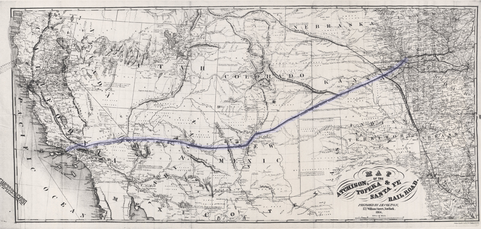
In the early 1850s, as the United States expanded westward, national interest grew in finding a viable transcontinental railroad route. Congress appropriated funds in 1853 for multiple surveying expeditions to explore different potential routes across the West.
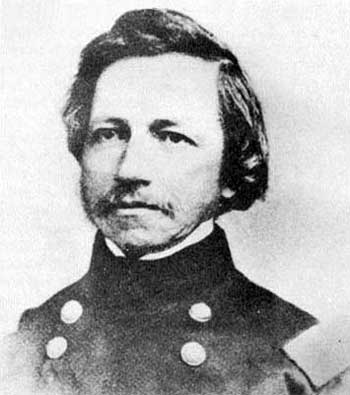
Lt. Amiel Weeks Whipple
Under the direction of Secretary of War Jefferson Davis, the Army’s Corps of Topographical Engineers organized surveys along several parallels. Lieutenant Amiel Weeks Whipple, a West Point-trained engineer, was chosen to lead the study near the 35th parallel north, roughly following a westward line from Arkansas to California. The goal was to assess the terrain’s suitability for a railroad, measuring distances and grades, locating mountain passes, and noting the availability of water, timber, fuel, and other resources critical for railway construction. This effort was part of a larger Pacific Railroad Surveys program, which dispatched teams to investigate northern, central, and southern routes for the first transcontinental railroad.
John Milton Bigelow, a physician and botanist
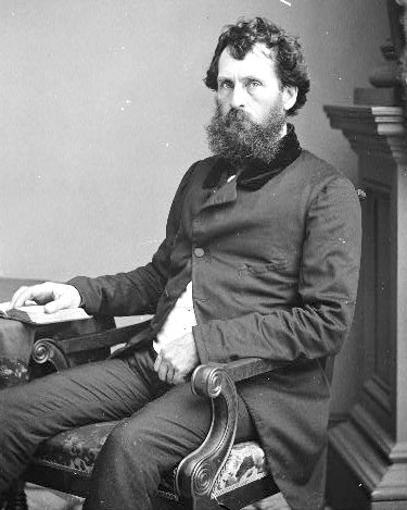
Whipple was already an experienced surveyor. He had worked on the U.S.–Mexico boundary survey after the Mexican–American War and had a reputation for scientific thoroughness. For the railroad survey, Whipple assembled a multidisciplinary team of about seventy men, including Army soldiers for security, teamsters to handle the wagons, and a number of scientists and specialists. The Smithsonian Institution helped select many of the expedition’s experts, reflecting the survey’s dual nature as both a route reconnaissance and a scientific exploration of the largely unmapped Southwest. Notable members of Whipple’s party included John Milton Bigelow, a physician and botanist; Jules Marcou, a geologist from France; and Balduin Möllhausen, a German artist and naturalist who had the backing of famed explorer Alexander von Humboldt. Lieutenant Joseph C. Ives, a young Army engineer, served as Whipple’s second-in-command and led a sub-party during the journey. The team’s diverse expertise meant that, in addition to plotting a railroad route, they would document the region’s flora, fauna, geology, and ethnography in unprecedented detail.
Journey from Fort Smith to New Mexico Territory
Lt. Joseph Christmas Ives
Whipple’s expedition officially commenced in mid-July 1853 at Fort Smith, Arkansas, then a border outpost to Indian Territory (present-day Oklahoma). The caravan – a long train of wagons and pack animals – set westward from Fort Smith on July 15, 1853. The team initially followed established trails where possible: they crossed the Poteau River into Indian Territory and proceeded along rough wagon roads just south of the Canadian River. This path had been traversed a few years earlier by expeditions such as Captain Randolph Marcy’s 1849 wagon road survey to Santa Fe. Even so, much of the region remained sparsely charted. The landscape of eastern Oklahoma was a patchwork of settlements belonging to relocated Native American nations (Choctaw, Chickasaw, Creek, Seminole, Cherokee, among others). As they traveled through these inhabited areas, Whipple often sought advice and guides from local Native people. The party moved steadily but cautiously, averaging only a few dozen miles per day due to the heavy wagons and the need to survey as they went.
Throughout the Indian Territory, Whipple was struck by the relative fertility and land resources. In contrast to earlier notions of the Southern Plains as part of the “Great American Desert,” Whipple described parts of what is now Oklahoma in encouraging terms. His team noted ample timber stands in regions like the Cross Timbers and discovered occurrences of coal, both assets for any future railroad. They found the prairie soils suitable for agriculture, observing that the area could yield abundant crops with sufficient water. Wildlife was surprisingly scarce along their route at first (likely due to overhunting and the presence of settlements). Still, as the expedition progressed into less populated areas, they encountered more game, including herds of bison and the occasional bear on the plains. The surveyors also recorded observations on the Native tribes they met. Whipple, with an ethnographer’s eye, collected information on indigenous languages and customs. He and his colleagues compiled vocabularies of various Native languages and noted the social conditions of the tribes, many of whom had been relocated to the Territory. The hospitality of local Native leaders helped the party traverse the region; in return, Whipple’s reports portrayed the tribes in a largely favorable light and even noted their openness to the idea of a future railroad bringing new opportunities.
By late summer, the expedition reached the Texas Panhandle, entering an environment of open high prairie. Here, the going became more challenging – the trails were faint, water sources more intermittent, and the heat and dryness more intense. In early September, the party was trekking across the flat expanse known as the Llano Estacado (Staked Plain) in what is now the Texas–New Mexico border area. Despite the hardships of travel across these arid plains, Whipple remained optimistic about the route’s potential. He reported that much of the rolling prairie appeared well-suited for laying track, with gentle grades and few significant barriers. Occasional hazards did arise: at one point, massive prairie fires swept across the dry grasslands, forcing the survey team to move camp to avoid the flames hurriedly. Nevertheless, the expedition pressed onward without major incident by carefully timing their marches between water holes and taking guidance from seasoned frontier scouts.
In early October 1853, Whipple’s party reached Albuquerque in the New Mexico Territory. This was a significant milestone and a chance to regroup. Albuquerque had been an outpost on the old Santa Fe Trail, providing a place to resupply and rest after the long plains crossing. Here, the expedition was joined by Lieutenant Ives’s detachment, which had taken a slightly different approach route. Ives and a small group had traveled separately via a southern path, moving from the Gulf of Mexico through Texas (through San Antonio and El Paso) and northward up the Rio Grande to rendezvous with Whipple. The combined expedition, now fully assembled in Albuquerque, prepared to tackle the most demanding portion of the journey: the remote deserts and mountains between New Mexico and California. They hired an experienced guide, Antoine Leroux, a frontiersman familiar with western trails, to assist in navigating the unknown terrain ahead. As autumn turned to winter, Whipple’s caravan departed Albuquerque, heading west into increasingly rugged country.
Across Arizona and the Mojave Desert to California
Leaving the relative civilization of the Rio Grande valley, Whipple’s survey entered what is now Arizona – a land largely unmapped by Americans at that time. The expedition first passed through the lands of the Zuni Pueblo, one of the Indigenous villages in western New Mexico. Whipple was very interested in the pueblo cultures; he paused to exchange greetings and study their way of life briefly, even sketching and describing Zuni architecture and traditions for his report. The party struck out from Zuni across northeastern Arizona, traversing the Painted Desert region. They aimed for the Little Colorado River, which they reached by following ancient Native trails. This stretch was difficult: water and grass were scarce, and the winter cold began to set in. The surveyors likely encountered patches of snow as they ascended in elevation. Still, the group persevered, mapping the terrain carefully. They made note of volcanic formations and other geologic curiosities as they approached the lofty San Francisco Mountains (the San Francisco Peaks near modern Flagstaff, Arizona).
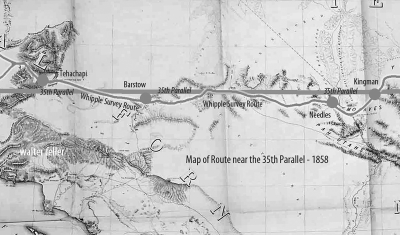
Guided by Antoine Leroux, the expedition found a pass through the San Francisco Mountains and descended into the basin of the Colorado River. By January 1854, they were in some of the most remote territory of the Southwest – a stark land of canyons and plateaus. Here, two Mohave Native American guides joined the party and proved invaluable. The Mohave people inhabited the river valley and deserts around the lower Colorado, and they knew the best routes through the arid labyrinth ahead. Under the guidance of these local scouts, Whipple’s team followed a path down a tributary called Bill Williams Fork to reach the Colorado River itself near the boundary of modern Arizona and California.
Crossing the Colorado River in the winter of 1854 was one of the expedition’s most significant challenges. The river was swift and cold, and the expedition had to build rafts or use whatever boats they could improvise to ferry men, animals, and equipment across. This crossing proveddisastrous – strong currents nearly swept away some of the party’s wagons and scientific collections. A makeshift raft capsized at one point, and several precious items (instruments and specimen jars) were lost to the muddy waters. Fortunately, no lives were lost, and Whipple managed to get his entire command safely to the western bank after considerable effort and delay. By February 7, 1854, the surveyors stood in California, having conquered the last significant natural barrier on their route.
Now the task remained to cross the vast Mojave Desert of southeastern California and reach the settled areas near the Pacific coast. The Mojave presented different obstacles: arid expanses, occasional sand dunes, and long stretches with no reliable water aside from a few springs. Still accompanied by their Mohave guides, Whipple’s party navigated along established Native trails that connected waterholes across the desert. They moved generally northwest from Colorado, eventually picking up the path of the old Mojave Road (a route used by Native Americans and the early Spanish travelers to California). This trail led toward the Mojave River, a critical lifeline in the desert. Following the Mojave River upstream (southwestward), the expedition could find water and grass for their stock at intermittent stream bends and oases.
Traveling along the Mojave River, Whipple noted signs of earlier travelers – evidence that this route had been used by Spanish missionaries, American fur trappers, and emigrant wagon parties in years past. They were approaching where the Mojave Road merged with the Old Spanish Trail and the newer Southern California wagon roads. The terrain gradually changed: dry lakes and creosote flats gave way to the higher elevations of the California Coast Range. The expedition’s final hurdle was to cross the San Bernardino Mountains via the Cajon Pass, the same pass used by traders and settlers to enter southern California. Cajon Pass was a natural mountain pass between the Mojave Desert and the coastal valleys. Whipple’s survey assessed this pass carefully, measuring its grade and width, and found it to be a favorable corridor for a railroad line. He reported that Cajon Pass, already well-traveled by wagons, could be engineered for locomotives without extraordinary difficulty – a significant affirmation, since this gap was the gateway to Los Angeles.
After emerging from Cajon Pass, the weary expedition descended into the green fields of southern California. They passed through the outskirts of San Bernardino, a young Mormon-founded community, and finally reached Los Angeles on March 20, 1854. This completed an epic journey of roughly 1,800 miles from the Mississippi River to the Pacific coast. Whipple’s team had spent about eight months on the trail, enduring extreme weather, rugged terrain, and occasional threats (from the environment more so than from people – indeed, relations with Native tribes along the way had been largely peaceful and cooperative). The triumphant arrival in Los Angeles marked the conclusion of the field survey. However, in many ways, Whipple’s work was just beginning: he now had to compile his findings and analysis for the government, recommending whether this 35th parallel route was suitable for a transcontinental railroad.
Scientific and Cultural Observations
Beyond its purely geographic accomplishments, the Whipple expedition made significant scientific and cultural contributions. It was, by design, a traveling research laboratory. The team’s specialists collected volumes of data and specimens throughout the trek. Botanist John Bigelow gathered hundreds of plant samples, discovering species new to science (many western plants would later be named in honor of Bigelow). Geologist Jules Marcou studied rock formations along the route, producing one of the first geological transects of the American Southwest – identifying coal seams and mineral deposits, and noting the volcanic origins of landscapes like the San Francisco Peaks. Topographical drawings and paintings by Balduin Möllhausen, the expedition artist, provided eastern audiences with their first realistic views of wonders such as pueblo villages, broad prairie vistas, and desert mountain ranges. Möllhausen also kept a personal journal describing daily life on the trail, which, along with the diary of assistant surveyor John P. Sherburne, offers vivid insights into the expedition’s experiences (both of these journals were later published and are valuable historical sources).
Lieutenant Whipple was intensely interested in ethnography (the study of cultures). As the expedition passed through regions inhabited by diverse peoples – from the settled Choctaw and Chickasaw farms in Indian Territory to the semi-nomadic Apache bands in New Mexico, the Pueblo villages, and the Mohave and Yavapai groups near the Colorado – Whipple took the time to observe and document their ways of life. He recorded information on tribal governance, agriculture, and daily customs. One notable effort was the compilation of vocabularies: Whipple’s report included comparative word lists for numerous Native languages encountered on the journey, preserving linguistic data that might have otherwise been lost. He was generally respectful in his descriptions, often noting the hospitality and helpfulness the survey party received. For instance, the Zuni and Mohave guides were crucial to the expedition’s success, and Whipple acknowledged their vital role in navigating the rugged country.
The scientific observations were not just academic; they directly tied into evaluating the railroad route’s feasibility. Whipple’s team cataloged where good timber stands grew (necessary for supplying wood for construction and fuel), where water was available year-round, and the locations of coal, iron, or other minerals that might support a railroad economy. In Oklahoma and New Mexico, they identified river valleys and mountain passes that could accommodate tracks with gentle gradients. In the drier sections of the route, they noted stretches that might require constructing wells or aqueducts to supply locomotives with water. The data collected on weather and climate led Whipple to an interesting conclusion: the 35th parallel route, he believed, had a climate “favored by precipitation” compared to some more northerly routes. In other words, he thought this middle-southern route received enough rainfall. He had enough perennial streams to sustain a railroad, without the extreme snowfalls that plagued routes farther north and without the absolute aridity of the far southern deserts. His final report reflected this climatic optimism, emphasizing the agricultural and settlement potential of the lands along the 35th parallel line.
Results and Legacy of the Expedition
Maj. Albert H. Campbell
Upon reaching California, Whipple and his colleagues turned to organizing their notes, maps, and collections. Over the next year, they prepared a comprehensive report for the War Department. Lieutenant Whipple authored the narrative of the journey and the analysis of the route’s suitability for a railroad. He highlighted that the expedition had identified a practicable rail corridor. There were only a few significant obstacles (notably the crossings of the Pecos and Rio Grande rivers and the passage through Cajon Pass), and even those could be overcome with engineering effort. Whipple’s engineer, A. H. Campbell, compared these challenges to building railroads in the Appalachians back east, implying that nothing in the West was insurmountable by modern (1850s) engineering standards. In Whipple’s estimation, the 35th parallel route offered an attractive balance: it was shorter than the far-southern route through Texas, avoided the highest peaks and snows of the central Rockies, and ran through regions that appeared fertile enough to populate and economically develop.
The U.S. government published the expedition’s official findings as part of a monumental series titled “Reports of Explorations and Surveys to Ascertain the Most Practicable and Economical Route for a Railroad from the Mississippi River to the Pacific Ocean.” Whipple’s report was contained in Volume III of the Pacific Railroad Survey Reports (1856), including his detailed narrative, maps, and journey illustrations. An accompanying Volume IV (1856) contained the scientific appendices: reports on geology, botany, zoology, and a significant essay by Whipple on the Native American tribes of the Southwest. These volumes were richly illustrated with lithographs based on Möllhausen’s sketches – images that introduced Americans to scenes like a Plains Indian encampment, a Pueblo village under the cliffs, and the majestic profiles of western mountain ranges. The reports were technical documents and essential works of natural science and anthropology for their time.
Balduin Möllhausen – writer, illustrator
Despite Whipple’s strong recommendation of the 35th parallel route, the decision on a transcontinental railroad was ultimately delayed by political conflict. In the 1850s, Congress remained deadlocked between Northern and Southern factions, each promoting different routes. No single route was chosen before the outbreak of the Civil War. Whipple’s careful survey, unfortunately, did not immediately lead to the construction of a railroad along his line. Indeed, when the first transcontinental railroad was finally built in the 1860s, it followed a more central route (far north of Whipple’s line) to connect Omaha with Sacramento. However, Whipple’s work was not in vain. His survey proved that a railroad could traverse the Southwest and helped identify the best passageways through a once-mysterious region. In the decades after the Civil War, railroad companies did turn to the 35th parallel corridor: the Atlantic and Pacific Railroad (later part of the Atchison, Topeka and Santa Fe Railway) built westward along much of Whipple’s path through New Mexico and Arizona. By the late nineteenth century, a transcontinental railway line was completed along the 35th parallel, validating Whipple’s original vision by providing a direct rail link to Los Angeles through the Mojave Desert.
The Whipple expedition also left a lasting legacy in science and exploration. The enormous collection of plant and animal specimens sent back east enriched American museums and led to the description of new species. The detailed maps produced by Whipple’s cartographers became base maps for the Southwest, used by future travelers, the military, and settlers. His ethnographic notes provided scholars with early documentation of Native cultures in regions that would soon experience dramatic change. Additionally, members of Whipple’s team went on to notable careers: Joseph Ives later led his famous expedition to explore the Colorado River in 1857; Balduin Möllhausen published his illustrated diaries and became known in Europe as an author on the American frontier; and Amiel Whipple himself continued his Army service, ultimately becoming a Union general in the Civil War (tragically, he was mortally wounded at the Battle of Chancellorsville in 1863).
In summary, Lt. Amiel W. Whipple’s 1853–1854 survey along the 35th parallel was among the most successful and influential Pacific Railroad Surveys. It combined meticulous route reconnaissance with scientific inquiry, painting a comprehensive picture of the lands between Fort Smith and Los Angeles. Whipple demonstrated that a railroad through the Southern Plains and Southwest was feasible and revealed the economic promise of that region. His expedition’s findings, published in the Pacific Railroad Survey volumes and subsequent works, helped guide the nation’s understanding of the Southwest and paved the way—literally and figuratively—for future railroads and settlements along his route.
Sources
Reports of Explorations and Surveys… Volume III (1856).Route near the Thirty-Fifth Parallel, under the command of Lt. A. W. Whipple. Washington: War Department, 1856. (Official Pacific Railroad Survey report with Whipple’s narrative, maps, and illustrations.)
Reports of Explorations and Surveys… Volume IV (1856). Washington: War Department, 1856. (Contains Whipple expedition’s scientific reports on geology, botany, zoology, and appendices on Native American tribes.)
Foreman, Grant (ed.). A Pathfinder in the Southwest: The Itinerary of Lieutenant A. W. Whipple during his Explorations for a Railway Route from Fort Smith to Los Angeles in 1853 and 1854. Norman: University of Oklahoma Press, 1941.
Gordon, M. M. (ed.). Through Indian Country to California: John P. Sherburne’s Diary of the Whipple Expedition, 1853–1854. Stanford, CA: Stanford University Press, 1988.
Conrad, David E. “The Whipple Expedition in Arizona, 1853–1854.” Arizona and the West 11, no. 2 (1969): 147–178.
Goetzmann, William H. Army Exploration in the American West, 1803–1863. New Haven, CT: Yale University Press, 1959.
& transportation in the 19th-century American Southwest
Edward F. Beale, Fort Tejon, and Overland Routes in the 19th-Century American Southwest
Part 1: Fort Tejon – Frontier Garrison and Strategic Hub
Fort Tejon was established on August 10, 1854, as a frontier military post at the southern end of California’s San Joaquin Valley, near present-day Lebec. Its mission was to guard the pass through the Tehachapi Mountains, oversee the newly established Sebastian (Tejon) Indian Reservation, and protect Native inhabitants and incoming settlers from raiding tribes of the Mojave and Great Basin deserts.
The fort replaced the less effective Fort Miller. It was chosen for its strategic position in Grapevine Canyon (Cañada de las Uvas), the primary north-south passage between Los Angeles and California’s interior valleys. Its largely adobe construction made it one of the more substantial frontier outposts in early California.
With an average complement of around 225 soldiers, Fort Tejon was manned chiefly by the 1st U.S. Dragoons, who carried out patrols, guarded travelers, and responded to tensions between Native groups and settlers. During its active years, Fort Tejon became the region’s military, political, and social center. It was also notable for being the post where several future Civil War generals—Union and Confederate—served.
One of the most dramatic episodes in Fort Tejon’s history was the January 9, 1857, earthquake. Estimated between magnitude 7.9 and 8.2, the quake caused widespread structural damage and left a surface rupture more than 220 miles long along the San Andreas Fault. Despite the destruction, the fort remained active.
The fort was critical in overseeing the Tejon Reservation and was at the heart of federal Indian policy in Southern California. Relations were complex: while the fort provided protection, it also enforced relocations and, at times, detained Native groups under harsh conditions. In 1863, following the Owens Valley Indian War, hundreds of Paiute people were forcibly marched to Fort Tejon and held near the fort in makeshift conditions.
Fort Tejon was initially evacuated during the Civil War in 1861 as regular Army forces were redeployed east. California volunteer forces briefly reoccupied it in 1863, primarily to maintain order and oversee Native groups. The post was permanently closed in 1864.
Edward Fitzgerald Beale, the fort’s most prominent figure, served not as a military commander but as Superintendent of Indian Affairs for California and Nevada. He helped plan the reservation system and was instrumental in placing the fort where it could support Indian policy and military objectives. After its closure, the site became part of the vast Tejon Ranch, acquired by Beale and expanded to nearly 270,000 acres.
Today, Fort Tejon is preserved as a California State Historic Park. Several original buildings have been restored, and the site serves as a tangible reminder of a period when military, political, and cultural frontiers converged in a single place.
Part 2: Overland Transportation in the 19th-Century American Southwest
In the decades following the Mexican-American War, the U.S. turned its attention to binding its far-flung western territories to the rest of the country. Before the railroads, the answer was overland travel—wagon roads, stage lines, and military escorts through harsh terrain and uncertain territory.
The Army played a central role in this endeavor. Military wagon roads were cut through mountain passes and deserts, often following earlier Native trails or Spanish routes. Among the most significant was Cooke’s Wagon Road, which 1846 became the first trail suitable for wagons from New Mexico to California. A series of federal surveys followed this to find optimal east-west routes.
Beale’s Wagon Road was one of the most ambitious and famous transportation projects of the pre-Civil War period. Between 1857 and 1859, Edward F. Beale surveyed and cleared a wagon route along the 35th parallel from Fort Defiance (now in Arizona) to Fort Tejon in California. His expedition also tested a new form of desert transport—camels—imported from North Africa. The camels performed well, but their novelty and the outbreak of the Civil War brought the experiment to an end.
Beale’s road provided a straighter, well-watered, and relatively level route across the Southwest. It later influenced the alignments of railroads like the Atlantic & Pacific and highways like Route 66 and Interstate 40.
At the same time, the Butterfield Overland Mail Company was operating the nation’s first true transcontinental stagecoach service. From 1858 to 1861, Butterfield coaches carried passengers and mail along a 2,800-mile route from Missouri to California. This southern path crossed through Texas, New Mexico, Arizona, and California to avoid snow in the mountains. Military forts—like Fort Tejon, Fort Yuma, and Fort Bowie—provided escort, supplies, and protection for the line.
The Butterfield route was relatively short-lived. With the outbreak of the Civil War, much of the southern corridor passed into Confederate territory, and the Union suspended the line in favor of more northerly routes.
Nevertheless, these early wagon roads were essential. They enabled mail delivery, troop movement, and civilian migration. In many cases, the roads laid by military engineers became the foundation for towns, trade routes, and railroads.
Throughout the latter half of the 19th century, railroads replaced wagons, and telegraphs replaced riders. However, many of the pathways carved by teams of soldiers and surveyors remained vital transportation corridors for decades, and some, like Beale’s Road and the Butterfield Trail, still echo through modern highways and desert backroads.
Selected References (no URLs)
California State Military Museum, “Historic California Posts: Fort Tejon”
George Stammerjohan, History of Fort Tejon
Sean T. Malis, Fort Tejon and California in the Civil War
Legends of America, “Edward F. Beale – Blazing the West”
National Park Service, Butterfield Overland Mail Project
The Hesperia Ditch was the heart of a bold dream to turn part of the Mojave Desert into a thriving agricultural community. Built in the late 1880s, it was the centerpiece of an irrigation system designed to carry precious water from Deep Creek to the dusty, sun-baked mesa where Hesperia began taking shape.
The story starts with a group of investors led by Dr. Joseph Widney, a former University of Southern California president. Along with the Hesperia Land and Water Company, Widney believed they could make the desert bloom by diverting water across rough terrain and under the Mojave River to what they hoped would become a green and prosperous settlement.
In 1886, they began building the ditch. It wasn’t a simple trench—it was an engineering project that included miles of open canal, flumes, and a steel pipeline that dipped under the Mojave River. The water came from Deep Creek, a rocky stream that runs through a canyon just south of modern-day Hesperia. The company built a small concrete dam at the intake point to raise the water level and direct it into a ditch blasted and dug along the canyon wall. That channel clung to the hillsides, sometimes cut into solid rock, and sometimes supported by stone walls or wooden flumes. The route was carefully graded to use gravity to keep the water moving.
One of the most impressive features of the system was a steel pipeline—about 14 inches in diameter—that crossed under the Mojave River in a kind of inverted siphon. From there, the water continued to a reservoir near present-day Lime Street Park in Hesperia. That earthen reservoir held about 58 acre-feet of water and was a local irrigation hub. Farmers could draw from it to water their fields, orchards, and gardens.
At its height in the early 1890s, the ditch helped irrigate over a thousand acres of land. Apples, peaches, alfalfa, and other crops were planted, and the new town of Hesperia began to take root with a hotel, train station, and grand ambitions. Optimists thought it would become the next great inland farming colony.
But dreams can be fragile in the desert. The irrigation system was expensive to build and even more complex to maintain. The 1880s land boom fizzled out, and Hesperia’s growth slowed. Legal disputes over water rights and the unpredictable nature of Deep Creek’s flow added to the difficulties. Floods often damaged the steel pipeline under the river and had to be repaired multiple times. By the early 20th century, much of the system was falling apart, and the amount of water it delivered had dropped significantly.
In 1911, a new group took over under the name Appleton Land, Water and Power Company. They made some upgrades, including installing a larger 30-inch steel pipeline for part of the route and reinforcing the intake works. Still, only a few hundred acres remained in cultivation. In 1916, just 90 acres of orchard and 220 acres of alfalfa and corn were being irrigated—far less than what had once been envisioned.
Even so, the ditch left its mark. Parts of the original channel along Deep Creek still exist today. A section of the Pacific Crest Trail follows the old ditch grade—its flat path a silent reminder of the engineers who carved it into the canyon wall over a century ago. The route is visible as a narrow shelf lined with old stonework along the hillside.
At Lime Street Park, where the reservoir once stood, a historical plaque honors the day in 1886 when “life-giving water” first reached Hesperia. Without the ditch, the town might never have taken hold. Though modern wells and pumps eventually replaced the irrigation system, the ditch was the first to prove that water could be brought to the high desert—and with it, the chance for people to stay, build homes, and try to make the desert bloom.
Today, the Hesperia Ditch is part of local lore, remembered as both a technical feat and a symbol of frontier determination. While the system didn’t fulfill all the lofty hopes of its founders, it made settlement possible in a place where nature had said no, and that’s no small thing.
In the spring of 1860, Bill Holcomb struck gold in a high mountain valley north of today’s Big Bear Lake. Word spread fast. By summer, a stampede of prospectors poured into what came to be known as Holcomb Valley, setting up tents, cabins, and mining claims. They hit pay dirt—some called it the richest gold strike in Southern California.
The mining camp that sprang up didn’t stay small for long. They named it Belleville, not after some prospector or politician, but after a baby—Belle Van Dusen, the newborn daughter of Jed Van Dusen, the town blacksmith. Her mother had sewn a makeshift American flag for the Fourth of July out of a miner’s shirt and a red petticoat, and the miners, feeling patriotic and maybe a little sentimental, gave the town her name.
Belleville boomed overnight. By the end of 1860, the town had thousands of residents—some say more than anywhere in the county except San Bernardino. The place had everything a gold camp needed: saloons, gambling halls, blacksmith shops, general stores, butcher shops, and a dance hall called the Octagon House. Of course, with that many miners and not much law, trouble came with it—shootouts, lynchings, and outlaw gangs made Belleville a wild place.
But there was a problem. The town was rich in gold and short on everything else, especially food and supplies. The only way in was by pack mule. Wagons couldn’t get through. If you wanted to bring a wagon to Holcomb Valley, you had to take it apart and haul it in pieces.
So the miners did something about it. They didn’t wait for the government. They scraped together about $2,000 in gold dust and hired someone they trusted: Jed Van Dusen. He was handy with tools, was already running the blacksmith shop, and knew the country. Jed built a wagon road from Belleville down the mountain toward the desert, connecting it with a new toll road through Cajon Pass built by John Brown Sr., another early pioneer.
Van Dusen’s road, finished in 1861, made all the difference. Wagons could reach Holcomb Valley from San Bernardino through Cajon Pass and Deadman’s Point. Supplies started flowing in: food, lumber, mining gear, blasting powder—even whiskey for Greek George’s saloon. Stagecoaches came too. What had taken a week by mule could now be done in two days by wagon.
That road helped Belleville grow even faster. Miners brought in stamp mills to crush rock and moved from panning in streams to blasting gold out of hard rock. Belleville got so bold it tried to steal the county seat from San Bernardino. In the 1860 election, it nearly succeeded—some say it did win, but one of the Belleville ballot boxes mysteriously ended up in a bonfire.
Of course, what goes up in gold country usually comes down just as fast. The easy gold dried up. The winter of 1861–62 was brutal—deep snow cut off the town for weeks. Miners left, saloons shut down, and Belleville started to fade. By 1864, it was nearly a ghost town.
But Van Dusen’s road stuck around. Even after Belleville was gone, the road he built continued to serve the area. Ranchers used it for cattle drives, loggers hauled timber down it, and the Forest Service later turned parts into official roads and ranger stations.
Today, the road still exists as Forest Service Road 3N09. Adventurous drivers can still follow the route Jed built by hand, more than 160 years ago. And if you walk through Holcomb Valley, you’ll find a few signs and stones where Belleville once stood—a rough mining town that burned bright and fast, and a road built by a blacksmith whose daughter gave the place its name.
In 1926, Nolie and Lela Murray did something bold. At a time when segregation kept Black families out of most vacation spots, they opened their own guest ranch in the desert outside Apple Valley, California. It was called Murray’s Dude Ranch, and it would become a rare oasis for Black travelers looking to relax, ride horses, and enjoy the wide open spaces of the West without being turned away.
Nolie Murray was a tall, well-dressed businessman from Los Angeles who owned a popular pool hall and cigar shop. His wife, Lela, was a trained nurse, petite and full of energy, always volunteering with civic groups and the church. When Lela’s health began to suffer from the damp city air, doctors suggested she move somewhere drier. They found that place near Bell Mountain, where a small Black homesteading community was taking root. A friend sold them 40 acres of dusty land for a token price, and the Murrays began building a new life.
They didn’t start out planning a dude ranch. At first, the property was a working ranch and a home for wayward youth. Lela and Nolie took in dozens of children—Black, white, and anyone who needed a second chance. The kids helped with chores and got to live in the fresh desert air. But running a ranch and caring for kids was expensive. By the 1930s, the Murrays were struggling to keep it going.
That’s when they saw an opportunity. Dude ranches were becoming trendy—city folks paying to pretend they were cowboys for a weekend. So in 1937, they opened their gates to the public. Murray’s Dude Ranch was one of the only places in the country where Black families could vacation with dignity. Guests stayed in bungalows, rode horses, swam, and gathered for home-cooked meals. Lela wore cowboy boots and a ten-gallon hat. Nolie stuck to his overalls. They treated every guest like family.
Word got around fast. The heavyweight boxing champ Joe Louis visited and brought national attention when Life magazine ran photos of him riding horseback at the ranch. Soon, Black entertainers like Lena Horne, Hattie McDaniel, and Herb Jeffries became regulars. Herb even filmed several of his all-Black Westerns on the property, bringing the image of Black cowboys to the big screen.
But it wasn’t just celebrities. Families came from across California, grateful to find a place that welcomed them. During World War II, the ranch even served as a USO club for Black servicemen, who were banned from the one in town. On Easter mornings, Lela hosted sunrise services for hundreds—Black, white, anyone who came.
After Lela died in 1949, Nolie tried to keep the ranch going, but things changed. More vacation spots began opening to Black families. In 1955, Nolie sold the property to singer Pearl Bailey and her husband Louie Bellson. They called it the Lazy B and used it as a private retreat for a few more years.
By the 1980s, the buildings were empty and falling apart. In 1988, firefighters burned down the last of them during a training exercise. Today, the land near Waalew Road and Dale Evans Parkway looks like just another patch of desert, but the story of Murray’s Ranch lives on in history books, old photographs, and the memories of those who once called it a safe and joyful place.
Murray’s Dude Ranch wasn’t just a vacation spot. It was a quiet act of resistance—proof that dignity, hospitality, and hard work could carve out a place of freedom in a segregated world. It gave hundreds of families a chance to ride horses under the high desert sky, to laugh, rest, and belong. And that’s something worth remembering.
In the mid-1880s, a group of ambitious developers set their sights on a stretch of the Mojave Desert, hoping to turn it into a thriving agricultural colony. They called it Hesperia, meaning “western land,” and it was meant to be a modern utopia in the High Desert. The people behind the plan were no small-timers—they included men like Dr. Joseph Widney, a prominent Los Angeles doctor and civic leader, and his brother, Judge Robert Widney. They were joined by big-name financiers like G.A. Bonebrake and E.F. Spence, and even the Chaffey brothers, who had already made their mark with the Ontario Colony.
Together, they formed the Hesperia Land and Water Company in 1885. They bought up around 35,000 acres and began laying out a townsite with wide streets, shaded sidewalks, and big dreams. They even built a grand three-story hotel made of adobe bricks and equipped with the latest luxuries—running water on every floor and indoor toilets, which were almost unheard of in the desert then. A small train depot on the California Southern Railroad made it easy for potential buyers to visit. Salesmen would meet trainloads of visitors with pink lemonade and promises of a blossoming future.
The company needed water, and lots of it, to make all this possible. In 1886, they staked a bold claim on Deep Creek, a fork of the Mojave River. They placed a rock monument near their water intake, intending to divert 5,000 miners’ inches of water per minute for use in Hesperia. They built a dam, canals, and even a steel pipe to carry water under the Mojave River to their new town. It was an impressive engineering feat for the time, and it allowed some early farming to take root—grapes, apples, and even a little wine-making found a foothold.
But the dream didn’t last. The great Southern California land boom collapsed in 1887, and the Hesperia project was one of its casualties. Very few people moved in, and the grand hotel stood nearly empty for years. Despite the setback, the water system stayed in place, and the company managed the land as best it could. Around 1911, the original company was reorganized into the Appleton Land, Water and Power Company, which tried again to breathe life into the project. A few small farms carried on, and the irrigation ditches continued to serve the scattered settlers.
One name that occasionally comes up in the town’s early history is James G. Howland. While not listed as one of the official founders, local accounts suggest he played a leadership role, possibly managing operations on the ground. He may have worked with the Chaffey brothers in Canada before coming to California, and some suggest he acted as a general manager or project overseer in Hesperia. Unfortunately, very little is known about him beyond that. He seems to have left the area or faded from public life after the initial boom ended.
The early efforts of the Hesperia Land and Water Company didn’t create the bustling town they had hoped for, but they left behind more than broken dreams. The water rights they claimed remained valid, and the town’s basic layout stayed the same. When post–World War II developers arrived decades later, they found roads, water systems, and legal groundwork already in place. Despite their failure to spark an immediate colony, these early visionaries planted the seeds— literally and figuratively—for what would eventually grow into the city of Hesperia. Their work, including the rock monument at Deep Creek and the remnants of the grand hotel, still echoes in the town’s heritage today.
1. No one owns it, but many try to control it. History, in its raw form—the past itself—belongs to no one. But the telling of history? That’s a different story. Governments, scholars, media, and even families all shape and reshape the narrative for various reasons: power, pride, justice, profit, or simply understanding.
2. The winners write the first drafts. You’ve probably heard the phrase, “The victors write history.” There’s truth in it—those with power or influence often get the loudest voice in historical accounts. But over time, that gets challenged.
3. Historians are stewards, not owners. Professional historians research, interpret, and present history, but don’t own it. They’re more like caretakers, using evidence to reconstruct the past. Still, their perspectives, training, and even funding can influence the stories they tell.
4. Communities own their stories. Local and Indigenous histories, family traditions, and oral accounts are often marginalized in official records. Yet they are crucial threads of the historical fabric. There’s growing recognition that these groups have a rightful say in how their stories are told.
5. You do, in a way. As a reader, researcher, or storyteller, you shape history. You decide what stories to share, what sources to trust, and what questions to ask. History is a collective memory, and each person helps choose what is remembered—or forgotten.
In the late 1800s, crossing the Mojave Desert meant bumping along uneven wagon ruts, hoping your team didn’t get stuck in deep sand or thrown off course by a flash flood. Early roads weren’t really “roads” at all—they were trails worn into the landscape by repeated travel, especially by miners, freighters, soldiers, and settlers. These rough paths linked desert mining camps like Calico, Panamint City, and Rhyolite to supply towns like San Bernardino, Barstow, and Los Angeles.
One of the most famous freight routes was blazed by Remi Nadeau, who used massive mule teams to haul silver and borax across the desert. Roads like the Bullion Trail were cleared by hand, just wide enough for wagons. The Mojave Road, first a Native trade route, became a military supply line after the U.S. Army established outposts like Fort Mojave.
Things changed with the invention of the Fresno Scraper in the 1880s. Before this tool, road grading was done with picks, shovels, and slip scrapers that barely moved enough earth. The Fresno Scraper, pulled by horses or mules, could scoop, carry, and deposit dirt efficiently—perfect for building up roadbeds and ditches in loose desert soil. It sped up construction and allowed workers to crown roads for better drainage, a critical improvement in a region prone to flash floods.
Railroads arrived in the desert by the late 1800s, including the Atlantic & Pacific, Southern Pacific, and Tonopah & Tidewater. While they made long-distance freight travel easier, they also created the need for short feeder roads to mining districts. These connections were often built with Fresno scrapers and early gasoline-powered graders by the 1910s.
As automobiles grew popular in the early 1900s, so did the need for better roads. The desert’s deep sand, sharp rocks, and dry washes were a nightmare for early drivers. Clubs like the AAA and promoters of the Arrowhead Trail began improving routes and placing signs to guide travelers across the Mojave. Oil-treated surfaces helped suppress dust, and wider grading made roads more durable.
Private entrepreneurs also took up the task. In 1925–26, Harry Eichbaum built a toll road over the Panamint Range to attract tourists to Death Valley. This road, carved through steep canyons and over rocky passes, later became part of State Route 190.
With federal aid laws passed in 1916 and 1921, California began standardizing desert highways like US 66, US 91, and US 395. Road building shifted from makeshift efforts to organized public works, supported by surveying, culverts, and modern grading machines.
What began as a harsh and unreliable network of trails evolved into a web of graded, signed, and—eventually—paved highways, making the Mojave Desert more accessible to settlers, travelers, and dreamers. The scars of early roads can still be seen today, fading into the sand alongside the remains of the towns they once served.
In the final months of 1864, while the nation was still locked in the chaos of the Civil War, a wagon train rolled slowly across the American frontier. Among its passengers were two families whose names—at least in one case—would echo through the pages of Western legend. The Rousseaus were heading west in hopes of a new beginning. Hardened by war and failure, the Earps sought a better future in California. Leading the wagon train was Nicholas Porter Earp, father of Wyatt Earp, and it was here—on the unmarked road between Salt Lake and San Bernardino—that stories of strength, tension, and hardship unfolded, written down by the steady hand of Sarah Jane Rousseau in her trail diary.
Nicholas Earp was, by any account, a man built for difficult times. Born in 1813, he had lived through the War of 1812 as a boy, served in the Black Hawk War, and later took up arms in the Mexican-American War. He had worked as a farmer, a constable, and a jack-of-all-trades—never truly settling, always looking for something better over the subsequent rise. By 1864, Earp was in his early 50s, grizzled and stiff from rough work. He was also deeply set in his ways.
Descriptions of Nicholas during the journey paint him as short-tempered, headstrong, and deeply opinionated. He took command of the wagon train with the same kind of stern authority one might expect from a battlefield officer. There was little room for softness on the trail. Rules were rules. And if they weren’t followed, the consequences were loud, and sometimes threatening. This didn’t sit well with everyone.
While traveling with her husband, Dr. John Rousseau, and their children, Sarah Jane Rousseau kept a diary of the journey. Her writing is a rare window into the human side of westward migration, especially from a woman’s point of view. She recorded weather patterns, daily mileage, and significant encounters. But she also took note of personalities and frictions along the trail, and Nicholas Earp features more than once in that record, which is not always favorable.
At one point, Sarah wrote that Earp threatened to whip children—including, perhaps, her own. The details are brief, as was her style, but the implication is clear: he had a temper and believed in discipline the old-fashioned way. To modern readers, this feels shocking and harsh, but in 1864, it wasn’t unusual.
Earp’s behavior was fairly common for the time. Discipline, especially of children, often came with raised voices and raised hands. A man like Nicholas, shaped by war and hardship, would have seen his role as head of the train—and his family—as one of control, protection, and order. His approach to leadership was informed by a world in which survival often depended on obedience. There was little room for backtalk or disobedience when you were facing down the deserts of Utah and Nevada, with limited water and no help for miles.
As the wagons moved south from Salt Lake City, they picked up the Mormon Road, a rough route that cut across the Great Basin and the Mojave Desert. This trail, used by Mormon settlers on their way to California, was dry, dangerous, and unforgiving. The group passed through Beaver and Parowan, Utah, into southern Nevada, and then down into the California desert, where their trials multiplied.
In her diary entry dated December 4, 1864, Sarah recorded a chilling stop near Salt Spring, on the southern edge of Death Valley. There, they found the remnants of a mining operation where three men had recently been killed—possibly by local Native Americans. Sarah noted the presence of four abandoned buildings and a quartz mill, and the unease in the camp was palpable. The group was vulnerable, tired, and on edge.
A short time later, they reached Bitter Springs, another desolate stop known for its sparse water supply. According to Sarah, local Native people approached the wagon train but did not attack—perhaps because of the size of the party, or perhaps because their intentions were peaceful. Still, the tension must have been thick in the desert air.
As the days wore on, tempers grew shorter. Food and water grew scarce. Animals began to falter. And the relationships among the travelers frayed. Nicholas Earp’s hardline leadership—so natural to him—probably became harder to tolerate under such conditions. His background, age, and sense of authority collided with the growing exhaustion of those around him. Sarah’s quiet observations hint at these dynamics, even if she never spells them out directly.
And then there was Wyatt Earp—just 16 years old, along for the ride with his family. Later, he would become one of the most iconic lawmen of the Old West, but during this journey, he was simply a boy on a horse. Sarah barely mentions him. He rode. He hunted. He wore out horses. He did not yet command attention. His father’s shadow was too long.
Eventually, the wagons followed the Mojave River, moving past waypoints like Camp Cady or Lane’s Crossing, before climbing the rugged terrain of Cajon Pass. From there, it was a descent into green hills and relative safety. In San Bernardino, they would find civilization—such as it was—and a temporary end to their troubles.
But that journey, and the roles people played in it, stuck. Sarah’s diary survived to tell the tale. In her pages, we see a woman navigating not just a trail, but a world of personalities, expectations, and power struggles. We see Nicholas Earp not as a villain or a hero, but as a man of his time—unyielding, protective, severe. We see the toll that hard roads take on even the hardest men.
And in the background, quietly riding along, was a teenager who would one day walk down a dusty street in Tombstone. But for now, he was just Wyatt—young, restless, and learning, perhaps unconsciously, what it meant to survive in a world ruled by men like his father.
In the mid-1920s, a man named H.W. Eichbaum looked out at the harsh desert landscape of Death Valley and saw something else entirely—a chance to bring travelers into one of the most remote and misunderstood places in California. Eichbaum, an engineer with a background in mining and tourism, had already run successful ventures on Catalina Island and in Venice, California. But the desert kept calling him back.
At the time, Death Valley had no real roads for cars. Miners knew the place, but tourists stayed away. Eichbaum dreamed of building the valley’s first resort at Stovepipe Wells, but first, he needed a road. He made multiple proposals to the Inyo County Board of Supervisors before securing approval in October 1925. The deal allowed him to build and operate a toll road down into Death Valley from Darwin Wash across Panamint Valley and Towne Pass.
The road was built by hand and Caterpillar tractor, winding around boulders rather than blasting through them. It was rough, narrow, and at times treacherous, but by spring 1926, the road reached the edge of the Mesquite Flat Dunes—just shy of his goal. Still, Eichbaum opened his Stovepipe Wells Hotel later that year, and tourists soon followed. His promotional savvy, regular ads in Los Angeles papers, and a sightseeing bus company helped make Death Valley a winter destination.
Eichbaum’s road and resort kicked off auto-tourism in the valley, but he didn’t live to see its full impact. He died in 1932, just before Death Valley became a national monument. As traffic grew and tolls became unpopular, the state eventually took over the route, paving it into what’s now part of California Highway 190. Some rough segments still exist as backcountry routes. But thanks to Eichbaum’s vision and grit, Death Valley was no longer just a miner’s haunt—it became a destination.
Wrightwood, California, nestled in the San Gabriel Mountains, has long inspired photographers to capture its charm, seasons, and community spirit. From black-and-white postcards to vivid digital landscapes, a handful of dedicated photographers have helped preserve this mountain town’s history through their lenses.
Burton Frasher was one of the earliest travelers to the Southwest in the 1920s and 30s, producing black-and-white postcards under the name “Frasher’s Fotos.” His pictures of Wrightwood, like the old clubhouse and the snow-covered lodge, offer a quiet, nostalgic look at what the town was like nearly a century ago.
Another local legend, Helga Wallner, took a more personal approach. She wasn’t just behind the camera—she was part of the community. Helga owned the Four Seasons Art Gallery on Park Drive and was known for her love of hiking, wilderness, and artistic expression. Her photographs of Wrightwood and nearby Big Pines can still be found in the town’s historical museum, reflecting her deep connection to the land and people.
Walter Feller, the mind behind the Digital-Desert website, brought Wrightwood into the modern era with landscape photography and digital storytelling. His photos of snow-covered trees and sunlit trails—sometimes paired with poetry—help others see the area as he does: full of quiet beauty and historical weight. His aerial shots of the town and the nearby regions give a unique perspective that blends natural wonder with careful observation.
Bill Zita, a local firefighter, also documented the town’s day-to-day life for over four decades. His color photos—more than 500 of them—are collected in the book On Call, showing everything from fires to festivals. Through his lens, Wrightwood becomes a living, breathing place.
Moses Sparks, a more recent contributor, focuses on wildlife and nature photography. His work, featured in local exhibits, captures the untamed side of Wrightwood—bobcats, hawks, and quiet forest scenes that many residents only glimpse in passing.
Gary Tarver brings a more intimate, journalistic style to his portraits and event photography. With decades of experience and a knack for natural moments, Gary helps people see Wrightwood as a place and a community.
Together, these photographers—Frasher, Wallner, Feller, Zita, Sparks, and Tarver—have created a visual legacy of Wrightwood that spans generations. Whether through dusty postcards, crisp digital prints, or family portraits, their work tells the story of a mountain town that still knows how to pause and pose for the camera.
Here is a merged, humanized historical essay about Jacob Nash Victor and the naming of Victorville:
Jacob Nash Victor was a determined railroad pioneer whose work helped shape the future of Southern California. Born in 1835, Victor was a civil engineer who eventually became general manager of the California Southern Railway, a crucial piece of the Atchison, Topeka, and Santa Fe Railway system. His efforts significantly contributed to the second transcontinental railroad in the United States by giving the Santa Fe route a Pacific Coast terminal.
Victor’s first major task in California was rebuilding 30 miles of washed-out track between Fallbrook and San Diego. But it was in 1883 that he made history. In a daring move, he cut through the Southern Pacific’s tracks at Colton, linking San Bernardino with the coast. Then, in 1885, Victor drove the first locomotive through the steep and rugged Cajon Pass, finally connecting San Bernardino with Barstow and completing the Santa Fe’s transcontinental route. These milestones were celebrated with flowers on the engines and public festivities in San Bernardino. Locals understood the importance of what had just been achieved.
Victor, proud of the feat, reportedly said, “No other railroad will ever have the nerve to build through these mountains.” He added, “All that follow will prefer to rent passage from us”—a prophetic statement when, 17 years later, the Salt Lake Route (now Union Pacific) followed the same path.
After retiring from the railroad, Victor continued his public service as a San Bernardino County Supervisor during a tense time when Riverside was trying to split from the county. He championed a direct tax that led to the construction of the Old Stone Courthouse at Court and E Streets, which stood until 1927. He also helped oversee the development of many county roads, leaving a lasting mark on the region’s infrastructure.
Following a second retirement, Victor and his wife, Elizabeth Blackwell Blue, spent summers in the East but always returned to San Bernardino for the winter. They considered it home and now rest in Mountain View Cemetery in San Bernardino.
In 1901, to avoid confusion with Victor, Colorado, the U.S. Post Office officially changed the name of the desert town from “Victor” to “Victorville.” The new name preserved Victor’s legacy while giving the growing community its own identity—one still rooted in the bold spirit of the railroad that helped put it on the map.
Learning the local and regional history of the Mojave Desert means tuning into a layered story shaped by environment, survival, movement, and adaptation. It’s a desert, yes—but not empty. Its history is written in petroglyphs, wagon ruts, mining tailings, rail ties, homestead ruins, and the still-beating hearts of small towns.
Local history in the Mojave often starts with places: a spring, a crossroads, a mine, a family ranch. These places tell human-scale stories—Chemehuevi trade paths, Paiute irrigation techniques, 19th-century stage stops, homesteaders braving wind and isolation. One town might have formed around a reliable water source or a rail siding, then boomed with mining or wartime industry and faded again when the ore ran out or highways shifted.
Regional or provincial history connects those dots. The Mojave’s broader story includes Spanish exploration, military campaigns, rail competition (think Southern Pacific vs. Santa Fe), and the spread of infrastructure like Route 66 and the aqueduct systems. You also see how waves of federal policy—land acts, park creation, military use—shaped wide swaths of desert land and life.
To truly learn it, you piece together:
Oral history from Indigenous communities and old-timers
Newspapers and legal records from mining districts and rail towns
The deeper history of a place doesn’t usually begin with grand events or famous names—it starts small. One family is settling near a spring. A trail worn down by generations of feet. A store that sold more than goods—it passed along stories. These local pieces might seem scattered or minor at first, but when you look closer, they connect. Like layers of soil in a core sample, each one has a story, and stacked together, they tell the history of a whole region.
Here’s how these local stories help us understand the bigger picture:
They show what happened on the ground. Big histories often discuss things in general terms—laws passed, wars fought, economies shifting. Local history shows how those things played out. Maybe a new law was ignored in one town, or a railroad line shifted the heart of another. It adds the human detail that broad overviews miss.
They show how everything connects. A small mill might seem like a side note until you learn it supplied lumber for rebuilding a major city. A desert trail might have been a supply route in wartime. These connections help explain why things happened the way they did.
They correct the record. Big histories often skip over places that seem unimportant. But digging into local documents, graveyards, and old newspapers can reveal surprises—and sometimes challenge what we thought we knew.
They keep culture alive. Local history holds onto things the bigger stories often lose: old place names, folk sayings, recipes, and customs. These details matter, especially for communities that have been pushed aside or erased over time.
They give historians the raw material they need. All those national and provincial stories are built on the little things: land deeds, school records, letters, maps. Without this groundwork, the larger story would have no foundation.
They show cause and effect in real life. You can’t explain a regional rebellion or a major irrigation plan without looking at what happened in the specific towns and valleys involved. That’s where you see how plans succeeded—or failed—and what it meant for the people living there.
Local history matters because it puts people back into the picture. It turns maps into places, and dates into stories. Want to understand a region? Start small. That’s where the truth lives.
Initially, negotiations between the California Southern and the Southern Pacific over securing a route from Needles to the Pacific Coast proved difficult. The Southern Pacific, which held effective control over the only existing line across the Mojave Desert, was in no hurry to assist a potential rival. The Southern Pacific’s leadership, accustomed to monopolizing rail access into and across California, viewed any arrangement that would aid an eastern competitor with deep suspicion.
Faced with obstruction and unreasonable demands, the California Southern and the Atlantic and Pacific Railroads—both closely tied to eastern capital—announced a bold plan. If the Southern Pacific would not cooperate on reasonable terms, they declared they would jointly undertake the construction of an entirely new and independent railroad across the desert. This proposed line would have paralleled the Southern Pacific’s existing track but remained free of its influence, offering the first serious threat to the Southern Pacific’s dominance over desert transportation.
The announcement was not a mere bluff. Surveys were conducted, routes were studied, and eastern investors, eager to establish a competitive foothold in the California market, were prepared to finance the new line. The specter of competition alarmed the Southern Pacific. It recognized that the construction of a rival road could undermine its existing investments, dilute its control, and establish a permanent eastern presence in southern California on terms not of its choosing.
California Southern Railroad construction in Cajon Pass
To avoid a costly and unpredictable conflict, the Southern Pacific made a calculated decision. In October 1884, it agreed to sell the line between Needles and Mojave—a route built initially by its construction arm, the Pacific Improvement Company. By doing so, the Southern Pacific sidestepped a potential rival and still profited from its investment in the desert.
The transfer was a turning point. With control of the Needles-Mojave line secured, the California Southern could at last resume construction in earnest, repairing flood damage and completing its transcontinental link. By late 1885, trains could run from San Diego to Barstow, and by 1886, the California Southern itself had been acquired by the Atchison, Topeka, and Santa Fe Railway, effectively sealing the eastern invasion into California’s rail market.
California Southern and Atlantic and Pacific Railroad: Timeline with Notes (1880–1886)
October 12, 1880 – Charter Granted The California Southern Railroad Company is chartered to build a line from San Diego to San Bernardino, opening a new southern route to inland California.
May 23, 1881 – Extension Planned The California Southern Extension Company is chartered to extend the line northeast to connect with the Atlantic and Pacific Railroad, originally aiming for a point about 80 miles from San Bernardino.
August 1882 – Reaches Colton Track completed to Colton; the line begins to make inroads into Southern Pacific territory.
September 13, 1883 – Main Line Opened Full operation begins between San Diego and San Bernardino. California Southern faces strong opposition from the Southern Pacific almost immediately.
Winter 1883–1884 – Severe Flood Damage Torrential rains devastate Temecula Canyon. Thirty miles of track are destroyed, bridges are washed away, and ties are seen floating far out to sea. The company faces ruin unless major repairs are undertaken.
Early 1884 – Strategic Setback Southern Pacific, exercising influence over the Atlantic and Pacific Railroad, forces the eastern connection to be built at Needles on the Colorado River—far beyond the original plan—meaning California Southern must now cross 300 miles of mountain and desert.
Mid-1884 – Threat of Independent Construction In response, the California Southern and Atlantic and Pacific announce that if necessary, they will build a completely independent railroad across the desert to avoid using Southern Pacific lines. Surveys are ordered, and eastern backers prepare financing.
October 1884 – Southern Pacific Relents Rather than risk parallel competition, the Southern Pacific agrees to sell the Needles-to-Mojave line to the California Southern Railroad. The Pacific Improvement Company, an entity under the control of Southern Pacific, had built the track.
November 1885 – Line Repaired and Completed After extensive repairs and new construction, the California Southern opens through service from San Diego to Barstow, near the junction of the Atlantic and Pacific at Needles.
October 1886 – Control Transferred to Santa Fe The California Southern is formally absorbed into the Atchison, Topeka, and Santa Fe Railway system, becoming part of a major transcontinental route and ending Southern Pacific’s near-monopoly over southern California rail traffic.
The struggles and ultimate success of the California Southern Railroad marked a turning point in the history of Southern California. By securing a route independent of the Southern Pacific’s control, the California Southern, under the wing of the Atchison, Topeka, and Santa Fe, opened the region to competition, lower freight rates, and new waves of settlement and development.
No longer isolated or captive to a single powerful railroad, San Diego and the inland valleys could now connect directly to the markets of the East. The great deserts and mountains that had once seemed impassable barriers became corridors of commerce and migration. In many ways, the hard-fought efforts of the California Southern and its allies helped lay the groundwork for the explosive growth of Southern California that would follow in the decades to come. It was a victory not only of rails and capital, but of determination against monopoly and geographic hardship.
Introduction The Borate & Daggett Railroad, a short-lived yet pivotal narrow-gauge railway, played a crucial role in the borax mining industry in California’s Mojave Desert at the turn of the 20th century. Its impact on the industry and its transition from traditional mule team freight to an efficient rail-based network make it a significant part of mining history.
In 1898, the Pacific Coast Borax Company, led by Francis Marion “Borax” Smith, constructed a narrow-gauge line that ran approximately 11 miles from the railhead in Daggett, California, to the mining camp of Borate near Calico. This railroad aimed to haul colemanite, a borax ore, out of the Calico Mountains, replacing the famous twenty-mule team wagon transports that had carried borax across the desert in the 1890s. The Borate & Daggett Railroad transitioned from traditional mule team freight hauling to an efficient rail-based network. It became a crucial link in a broader system of borax railroads that ultimately extended to Death Valley.
In the late 19th century, miners discovered large borax deposits in California’s deserts. They valued borax for its use in detergents and industrial processes. In 1883, prospectors found a rich colemanite borax deposit in the Calico Mountains. Mining entrepreneur William Tell Coleman, known for operating borax mines in Death Valley and using 20-mule team wagons to haul borax across long desert routes, acquired the claim. Coleman later sold his borax properties to Francis Marion Smith, who formed the Pacific Coast Borax Company in 1890.
By the late 1890s, the Borate mine near Calico produced thousands of tons of ore annually. Initially, borax was transported to the railhead at Daggett by 20-mule teams, a slow and costly process. An attempt to replace the teams with a steam-powered traction engine named “Old Dinah” failed due to the desert terrain, leading to the innovative solution of building a narrow-gauge railroad. This marked a significant transition from traditional mule team freighting to a more efficient rail-based network, reducing costs and modernizing transport.
Construction of the Borate & Daggett Railroad (1898)
The railroad was completed in 1898, running 11 miles from Daggett to Borate through Mule Canyon. It used a 3-foot gauge track with steep grades and trestles to navigate the rugged terrain. Two Heisler steam locomotives, “Marion” and “Francis,” handled the ore trains. A roasting mill was built midway at a Marion site to process the ore before shipment, and a third rail allowed standard-gauge boxcars to be loaded there.
Operations and Infrastructure
The railroad regularly hauled borax ore to Daggett, where workers reloaded it into Santa Fe Railway cars for transport. The system improved efficiency, replacing the mule teams entirely and reducing costs. The mill at Marion roasted and sacked the ore, streamlining shipment by loading directly into standard-gauge cars.
Replacing the Twenty-Mule Teams
The railroad’s completion in 1898 marked the end of the mule team era for borax hauling in the Calico region. Daggett, once a hub for mule teams, evolved into a rail center. The shift to rail transport significantly increased output and reliability for the Pacific Coast Borax Company.
Expansion to Death Valley:
The Tonopah & Tidewater Railroad By 1904, ore quality at Borate declined. Smith turned to the Lila C Mine near Death Valley, discovered richer deposits, and began building the standard-gauge Tonopah & Tidewater Railroad in 1905. By 1907, the new line reached Death Valley Junction, prompting the shutdown of the Borate & Daggett line. Operators relocated all activities north, resulting in the abandonment of the narrow-gauge line.
The Death Valley Railroad, built in 1914, served the new mines at Ryan, CA. It connected to the Tonopah & Tidewater at Death Valley Junction. Equipment from the Borate & Daggett line, including its locomotives, was reused during construction. The Borate & Daggett, Tonopah & Tidewater, and Death Valley railroads formed a network supporting the borax industry across eastern California and Nevada.
Decline and Abandonment
In 1907, they abandoned the Borate & Daggett Railroad, removed the tracks, and relocated or stored the equipment. The Borate mine and camp stood deserted, while Daggett’s narrow-gauge facilities lay unused. Workers later moved a locomotive repair shop from the line to Daggett and repurposed it.
Legacy and Remnants Today
Even though the railroad has been gone for over a century, off-roaders still use the route through Mule Canyon, where you can see remnants of trestles and the old roadbed. Ruins and mine openings still mark the Borate townsite. A historic garage built from the original repair shop still stands in Daggett. Death Valley museums showcase artifacts like Old Dinah and original 20-mule team wagons.
The Borate & Daggett Railroad helped usher in a new era of borax mining, replacing animal transport with rail efficiency. Its brief life laid the groundwork for a more extensive borax rail network, which was crucial in the history of desert mining.
In the spring of 1776, while revolution stirred on the East Coast, something quieter, though no less meaningful, was happening far in the West. A Spanish Franciscan missionary, Father Francisco Garces, was on his fifth and final journey into the heart of what is now California.
Guided by Native people and traveling by foot and mule, Father Garces came up through the Antelope Valley, tracing ancient indigenous trails through uncharted territory to Europeans. From there, he pressed on into the San Joaquin Valley, turned east and crossed the rugged mountains near Tehachapi, and continued into the dry interior, heading toward the Mojave River.
During this leg of the journey, near the base of Castle Butte, east of present-day California City, someone in his party left behind a quiet message. Carved into a large boulder was a simple inscription: “Cura Garces – Abril 1776.” A trace is left in stone to mark their passage through the high desert.
That rock sat in silence for more than 150 years. Then, around 1935, an old prospector pointed it out to a man named Mike Sanchez, but the story of the stone didn’t go far. Sanchez wasn’t much of a talker, and the tale faded.
Later, in 1963, local historian Glen Settle gave a talk at an elementary school in Lancaster. A teacher there told him about the rock. One of her students—Mike Sanchez’s son—had shared the story, and he even had a hand-drawn map.
Two years later, in 1965, Settle and several other members of the Kern Antelope Historical Society followed that map and found the rock. It had already suffered some vandalism, so the group relocated it to a safe location. They called in a local man with a truck and a sturdy A-frame hoist. With help from a few Air Force sergeants, they carefully transported the rock to the Tropico Gold Camp Museum in Rosamond.
They brought in experts to study it. One priest, an authority on early Spanish California, confirmed that the words and cross were consistent with 18th-century Franciscan markings. The weathering on the carving was old, possibly as old as Garces’ journey.
During the 1976 U.S. Bicentennial, organizers mounted the rock on a traveling display. They showed it at schools and events throughout the Antelope Valley. It was a rare, tangible link between the Mojave Desert and the very year the United States was born.
In 1979, the rock was loaned to the new East Kern Historical Museum in California City, close to where it had first rested centuries earlier.
Then, tragedy struck in the dark hours of February 4, 1981. The museum caught fire. Local fire crews responded quickly, but upon arrival, the wooden structure was already fully engulfed in flames.
At first glance, the Garces Rock seemed to have survived the blaze. But it crumbled into fragments when someone gently touched it the next morning. The heat from the fire, followed by cold water from the hoses, had cracked and fractured the boulder beyond saving—even the carved inscription dissolved into dust.
Firefighters did everything they could. There was nothing left.
What was lost that night wasn’t just a rock. It was a rare and quiet witness to a moment of deep historical significance—when a European missionary followed Native guidance across the mountains, valleys, and deserts of early California.
Father Garces didn’t live long after his desert crossing. He was killed near the Colorado River in 1781, near what is now Yuma, Arizona. But his name still lives on in places like Garces Memorial High School in Bakersfield—built near the spot he once called a “beautiful place for a mission.”
Though the rock is gone, the story remains. It’s kept alive by teachers, old-timers, maps passed down, and folks who care enough to remember. It’s proof that sometimes the desert whispers back—and if you listen closely, you can still hear the footsteps of history echoing through the sand.
The modern history of Mojave Desert communities grew after the mining booms faded and railroads became less of a lifeline. Roughly from the 1940s to now, these places have been redefining themselves—not just surviving the desert but learning how to live with it in new ways.
Here’s how the modern community story unfolds, level by level:
1. Military and Aerospace Transformation (1940s–1960s)
World War II changed everything. The Mojave wasn’t just space—it became a strategic training and testing ground.
Camp Iron Mountain and Patton’s Desert Training Center trained soldiers for North Africa.
Pilots broke the sound barrier at Edwards Air Force Base, which grew into the heart of desert aviation.
China Lake and Fort Irwin brought high-tech military research to places like Ridgecrest and Barstow, drawing families and workers.
These bases turned small desert outposts into full-blown towns with schools, post offices, and diners.
2. Route 66 and the Roadside Era (1940s–1970s)
The desert became part of the great American road trip. Route 66 brought motels, neon signs, gas stations, and diners—places like Victorville, Needles, and Ludlow saw a boom in roadside business.
Families moved in, schools opened, and churches and drive-ins popped up. This was the golden age of “mom-and-pop” America in the desert.
3. Suburban Growth and Retirement Towns (1960s–1990s)
As Southern California’s population exploded, people started looking eastward for cheaper land and quieter lives.
Apple Valley, Hesperia, and Pahrump became bedroom communities.
Retirees settled in places like Yucca Valley and Desert Hot Springs, drawn by warm weather and low cost of living.
Victor Valley Community College, hospitals, and shopping centers brought permanence to areas that once just had a trading post or water tank.
But growth was a double-edged sword—water use soared, and the Mojave’s quiet shrank.
4. Conservation and Cultural Identity (1990s–Present)
As people realized how fragile the desert is, preservation efforts took root.
Mojave National Preserve was created in 1994.
Groups began restoring historic buildings, like the Kelso Depot and the Apple Valley Inn.
Indigenous communities began reclaiming space and stories, renewing ties to sacred sites.
Meanwhile, desert towns started embracing their unique character—ghost town tourism, art festivals, off-road races, and local museums began drawing visitors. The old pioneer spirit didn’t vanish; it just adapted.
5. Today: Challenges and Reinvention
Modern Mojave communities are still small, spread out, and shaped by heat, water, and distance.
Some focus on eco-tourism or renewable energy. Others wrestle with issues like poverty, declining services, or housing. But there’s pride in being from these places. Pride in the toughness it takes to make a home in the Mojave.
The modern story isn’t just one of change—it’s about finding a future while holding onto the past.
Tucked between the Inyo Mountains and the Panamint Range in eastern California lies Panamint Valley—a vast, arid stretch of desert where stories cling to the rocks and dust. Part of the northern Mojave Desert, this remote basin has seen centuries of human presence, from Native American trade routes and outlaw hideouts to a silver mining boom and military testing. Surprise Canyon is at the heart of this tale, a rugged cut through the mountains that once served as both a refuge and a gateway to fortune.
Native Roots and Early Exploration For thousands of years, the Timbisha Shoshone and other Native American groups lived in and around Panamint Valley. They followed game, gathered plants, and knew the subtle signs of water in this harsh landscape. Early explorers and pioneers during the California Gold Rush would later follow their trails. However, few stayed long in the face of the valley heat, dryness, and isolation.
Outlaws in Surprise Canyon In early 1873, three men hiding from the law—William L. Kennedy, Robert L. Stewart, and Richard C. Jacobs—discovered silver in the steep, narrow depths of Surprise Canyon. Some say they were drawn there by rumors of the Lost Gunsight Mine. Regardless, they struck it rich. Sources differ on the exact date: Nadeau places it in January, Wilson in February, and Chalfant in April. But by June, prospectors had filed 80 claims, and the ore was assaying at thousands of dollars per ton.
Big Money and Bigger Names Enter E. P. Raines, who secured a bond on some of the most promising claims and began promoting the new district. He drew attention by hauling a half-ton block of silver ore to Los Angeles and displaying it at the Clarendon Hotel. This bold stunt brought together jewelers, bankers, and freighters, who agreed to build a wagon road to the mines. Raines continued north to San Francisco and then Washington, D.C., where he met Senator John P. Jones of Nevada, a former Comstock miner and hero of a deadly fire. Jones loaned him $15,000 and soon partnered with fellow “Silver Senator” William M. Stewart to form the Panamint Mining Company.
The senators spent over $350,000 acquiring prime claims from known Wells Fargo robbers. Senator Stewart arranged amnesty for these men, with the condition that $12,000 in profits be paid to the express company as restitution. It is believed this arrangement convinced Wells Fargo to avoid opening an office in Panamint.
The Road to the Panamint Mines The silver rush in Surprise Canyon prompted the search for a better supply route. Senator Stewart noticed Meyerstein & Co., a San Bernardino firm, was already sending goods to the region. He encouraged Caesar Meyerstein to establish a stage line. In the fall of 1874, preparations began on a road from Cottonwoods on the Mojave River to the Panamints.
The Board of Supervisors appointed Aaron Lane as road overseer of the newly formed Mojave District. Lane hired a crew of Chinese laborers under foreman Charley Craw to begin construction. Miners objected to using Chinese labor, but Lane completed the project by mid-November. He advertised the route as an “excellent” road, and the Guardian praised the veteran for his work. Lane submitted a bill for $645.61, but the county approved only $500—a modest sum for 115 miles of desert road.
This San Bernardino-Panamint Road, sometimes called the Meyerstein Road or Nadeau Cut-Off, shortened the journey to the mines by cutting across from Cajon Pass through Victorville and Hodge (Cottonwoods), connecting with the Stoddard’s Well Road. While freighter Remi Nadeau operated the Los Angeles to Panamint route via Tejon Pass, the San Bernardino route originated separately. Despite the confusion in some sources, the Chinese labor used on the San Bernardino-Panamint Road under Captain Lane should not be mistaken for labor on Nadeau’s route.
According to the San Bernardino Weekly Argus, stops along the Meyerstein route included Meyerstein to Martin’s, Fears in Cajon Pass, Huntington’s (Victorville), Cottonwoods (Hodge), Wells, Second Crossing of the Mojave, Black’s Ranch, Granite, Willow Tree Station, and finally Post Office Springs, just before reaching Panamint. These links formed a vital corridor to one of the West’s wildest boomtowns.
The Rise of Panamint City By March 1874, Panamint had around 125 residents. It had no schoolhouse, church, jail, or hospital—and it never would. To avoid robbery on the lawless route to market, the senators cast silver into 450-pound “cannonballs” that could be hauled unguarded to Los Angeles. On November 28, the Idaho Panamint Silver Mining Company was formed with $5 million in capital, followed by the Maryland of Panamint and several others with an additional $42 million by year’s end. That same month, the Panamint News began publishing—though its editor fled town within days after stealing advertising revenue.
The town boomed. The winter of 1874-75 was its peak. Two stage lines operated, the Bank of Panamint opened, and 50 buildings lined Surprise Canyon. The Oriental Saloon claimed to be the finest outside San Francisco. Mules and burros were the main form of transport. The lone wagon doubled as a meat hauler and a hearse.
By January 1875, the population hit 1,500 to 2,000. Businesses thrived. A wire tramway sent ore from the Wyoming and Hemlock mines down to the Surprise Valley Mill and Water Company’s twenty-stamp mill. Wood costs $12 per cord, and miners earn $4 to $5.50 per day. The crumbling smokestack of this mill still stands. Daniel P. Bell, the mill’s builder, later died by suicide in Salt Lake City, reportedly after being diagnosed with cancer.
Crash and Decline Disaster came quickly. The collapse of the Bank of California in August 1875 shook confidence across the state. Panamint stock crashed, speculation dried up, and the Panamint News ceased publication. By November, the population had largely disappeared, with only a few hopefuls remaining. In July 1876, a cloudburst flooded Surprise Canyon, wiping out large sections of the town.
Senator Jones, once Panamint’s champion, held on until May 1877. But a market panic forced him to shut down the mill. Despite investing nearly two million dollars, the Silver Senators saw little return.
Later, Revivals and Post Office Spring Attempts to revive Panamint followed. Richard Decker reopened the post office during 1887 and worked claims into the 1890s. The site saw minor revivals into the 1920s and again in the 1940s. 1947-48, American Silver Corporation leased multiple claims and rebuilt the Surprise Canyon road but filed for bankruptcy in 1948. Interest returned in the 1970s, though the fractured and faulted veins proved challenging to follow.
Near the city ruins, Post Office Spring played an important role. Besides being a water source, it housed a secret mail drop during Panamint’s outlaw days. A box wired to a mesquite tree held letters marked “John Doe”; a rag on a nearby branch signaled mail had arrived. At night, fugitives collected or left messages in secret.
The Panamint Range: Geology and Life The Panamint Range, separating Panamint Valley from Death Valley, rises from about 1,000 to 11,049 feet at Telescope Peak. It’s part of MLRA 29f and features Precambrian sedimentary and metamorphic bedrock, Paleozoic marine sediments (Cambrian to Carboniferous), Mesozoic granite, and Pliocene basalt. Alluvial fans spread from steep slopes into the valleys. Processes shaping the range include mass wasting, fluvial erosion, deposition, and freeze-thaw cycles.
Vegetation follows elevation, too, from creosote bush and shadscale at lower levels to pinyon, limber pine, and bristlecone forests higher up. Surface water is scarce; streams run briefly during rains and snowmelt, draining into Panamint and Death Valleys.
The Road, the Valley, the Legend The road to Panamint, first carved to bring silver to market, is now a rugged path for adventurers. Panamint Valley itself, once crossed by Native trails and mule trains, is now visited by hikers, off-roaders, and desert wanderers: the Panamint Range towers above, its silent peaks guarding the stories of a forgotten boomtown.
Panamint is more than a ghost town. It mirrors Western ambition—where silver dreams, outlaw grit, and desert extremes shaped one of the wildest chapters in California history.