Tag: Mojave Desert history

  • The Cushenbury Grade

    The Cushenbury Grade is a steep and winding stretch of mountain road that climbs from the high desert of Lucerne Valley up to the pine-covered town of Big Bear Lake. Today, it’s part of California State Route 18, but long before pavement and guardrails, this canyon trail served miners, ranchers, and Native travelers through the San Bernardino Mountains.

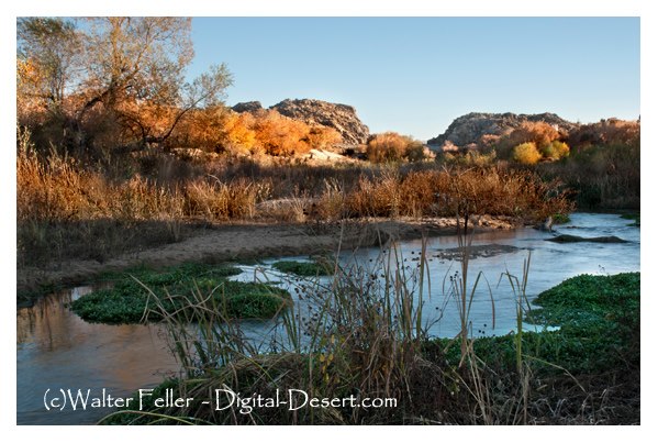
    Before roads were built, the Serrano people used footpaths through Cushenbury Canyon to move between desert and mountain environments. These routes followed natural contours through the rugged terrain and were later adopted by settlers.

    By the 1860s and 70s, prospectors, cattlemen, and freighters were dragging wagons up and down this slope. During the gold boom in nearby Holcomb Valley, Cushenbury became one of the main north-side routes into Big Bear. It was grueling work—steep grades, loose rock, and no guarantee your wagon would make it to the top in one piece.

    The canyon and grade took their names from the Cushenbury family, early settlers and cattle ranchers in the Lucerne Valley area. Their name stuck, and by the early 20th century, the area gained new attention, not for gold but for limestone.

    In 1918, rich limestone and marble deposits were discovered along the grade. This sparked industrial interest, and by the 1950s, Kaiser Cement had developed a massive limestone quarry near the top. A narrow-gauge rail system carried raw material down the grade to a processing plant: even today, trucks loaded with cement rumble up and down the slope.

    During the 1960s, the state upgraded the road and officially folded it into California State Route 18. This brought pavement, safety improvements, and better access to Big Bear from the desert side. Though safer now, the grade still features tight switchbacks and dramatic elevation changes, rising from about 3,000 feet in Lucerne Valley to over 6,700 feet at the top.

    Today, the Cushenbury Grade remains a key route for both commerce and recreation. It offers expansive views of the Mojave Desert below and a sense of just how much effort it once took to reach the mountains. Whether hauling limestone or heading up for a weekend getaway, this road directly links two very different worlds—desert and alpine.

    Timeline

    Cushenbury Grade Historical Timeline

    Pre-1800s:
    Indigenous Serrano people use Cushenbury Canyon as a seasonal travel route between the Mojave Desert and mountain forests.

    1860s–1870s:
    Miners and ranchers began traveling through the canyon using rough trails to access Holcomb Valley and Big Bear. The steep terrain made it tough for freight wagons and livestock.

    1880s:
    A more defined wagon road is carved into the canyon wall. It’s still rough going—narrow, rocky, and dangerous—but it’s one of the few ways into Big Bear from the desert.

    Early 1900s:
    The Cushenbury family settles in the Lucerne Valley area, giving their name to the canyon and grade.

    1918:
    Limestone and marble are discovered along the canyon. As mining gains momentum, the area shifts from wagon trail to industrial corridor.

    1950s:
    Kaiser Cement develops a large limestone quarry near the top of the grade. A private rail system is built to haul material to the desert floor. This leads to improvements along the road.

    1960s:
    The state paves and upgrades the road, officially making it part of California State Route 18. It becomes a year-round access route to Big Bear Lake from the high desert.

    1990s–present:
    The Cushenbury Grade is heavily used by cement trucks and tourists. The steep climb and sharp turns remain challenging, especially in winter, but it’s a vital link between two different environments.

  • Hesperia Ditch

    The Hesperia Ditch was the heart of a bold dream to turn part of the Mojave Desert into a thriving agricultural community. Built in the late 1880s, it was the centerpiece of an irrigation system designed to carry precious water from Deep Creek to the dusty, sun-baked mesa where Hesperia began taking shape.

    The story starts with a group of investors led by Dr. Joseph Widney, a former University of Southern California president. Along with the Hesperia Land and Water Company, Widney believed they could make the desert bloom by diverting water across rough terrain and under the Mojave River to what they hoped would become a green and prosperous settlement.

    In 1886, they began building the ditch. It wasn’t a simple trench—it was an engineering project that included miles of open canal, flumes, and a steel pipeline that dipped under the Mojave River. The water came from Deep Creek, a rocky stream that runs through a canyon just south of modern-day Hesperia. The company built a small concrete dam at the intake point to raise the water level and direct it into a ditch blasted and dug along the canyon wall. That channel clung to the hillsides, sometimes cut into solid rock, and sometimes supported by stone walls or wooden flumes. The route was carefully graded to use gravity to keep the water moving.

    One of the most impressive features of the system was a steel pipeline—about 14 inches in diameter—that crossed under the Mojave River in a kind of inverted siphon. From there, the water continued to a reservoir near present-day Lime Street Park in Hesperia. That earthen reservoir held about 58 acre-feet of water and was a local irrigation hub. Farmers could draw from it to water their fields, orchards, and gardens.

    At its height in the early 1890s, the ditch helped irrigate over a thousand acres of land. Apples, peaches, alfalfa, and other crops were planted, and the new town of Hesperia began to take root with a hotel, train station, and grand ambitions. Optimists thought it would become the next great inland farming colony.

    But dreams can be fragile in the desert. The irrigation system was expensive to build and even more complex to maintain. The 1880s land boom fizzled out, and Hesperia’s growth slowed. Legal disputes over water rights and the unpredictable nature of Deep Creek’s flow added to the difficulties. Floods often damaged the steel pipeline under the river and had to be repaired multiple times. By the early 20th century, much of the system was falling apart, and the amount of water it delivered had dropped significantly.

    In 1911, a new group took over under the name Appleton Land, Water and Power Company. They made some upgrades, including installing a larger 30-inch steel pipeline for part of the route and reinforcing the intake works. Still, only a few hundred acres remained in cultivation. In 1916, just 90 acres of orchard and 220 acres of alfalfa and corn were being irrigated—far less than what had once been envisioned.

    Even so, the ditch left its mark. Parts of the original channel along Deep Creek still exist today. A section of the Pacific Crest Trail follows the old ditch grade—its flat path a silent reminder of the engineers who carved it into the canyon wall over a century ago. The route is visible as a narrow shelf lined with old stonework along the hillside.

    At Lime Street Park, where the reservoir once stood, a historical plaque honors the day in 1886 when “life-giving water” first reached Hesperia. Without the ditch, the town might never have taken hold. Though modern wells and pumps eventually replaced the irrigation system, the ditch was the first to prove that water could be brought to the high desert—and with it, the chance for people to stay, build homes, and try to make the desert bloom.

    Today, the Hesperia Ditch is part of local lore, remembered as both a technical feat and a symbol of frontier determination. While the system didn’t fulfill all the lofty hopes of its founders, it made settlement possible in a place where nature had said no, and that’s no small thing.

  • Nicholas Earp, Sarah Jane Rousseau

    The Long Trail West

    In the final months of 1864, while the nation was still locked in the chaos of the Civil War, a wagon train rolled slowly across the American frontier. Among its passengers were two families whose names—at least in one case—would echo through the pages of Western legend. The Rousseaus were heading west in hopes of a new beginning. Hardened by war and failure, the Earps sought a better future in California. Leading the wagon train was Nicholas Porter Earp, father of Wyatt Earp, and it was here—on the unmarked road between Salt Lake and San Bernardino—that stories of strength, tension, and hardship unfolded, written down by the steady hand of Sarah Jane Rousseau in her trail diary.

    Nicholas Earp was, by any account, a man built for difficult times. Born in 1813, he had lived through the War of 1812 as a boy, served in the Black Hawk War, and later took up arms in the Mexican-American War. He had worked as a farmer, a constable, and a jack-of-all-trades—never truly settling, always looking for something better over the subsequent rise. By 1864, Earp was in his early 50s, grizzled and stiff from rough work. He was also deeply set in his ways.

    Descriptions of Nicholas during the journey paint him as short-tempered, headstrong, and deeply opinionated. He took command of the wagon train with the same kind of stern authority one might expect from a battlefield officer. There was little room for softness on the trail. Rules were rules. And if they weren’t followed, the consequences were loud, and sometimes threatening. This didn’t sit well with everyone.

    While traveling with her husband, Dr. John Rousseau, and their children, Sarah Jane Rousseau kept a diary of the journey. Her writing is a rare window into the human side of westward migration, especially from a woman’s point of view. She recorded weather patterns, daily mileage, and significant encounters. But she also took note of personalities and frictions along the trail, and Nicholas Earp features more than once in that record, which is not always favorable.

    At one point, Sarah wrote that Earp threatened to whip children—including, perhaps, her own. The details are brief, as was her style, but the implication is clear: he had a temper and believed in discipline the old-fashioned way. To modern readers, this feels shocking and harsh, but in 1864, it wasn’t unusual.

    Earp’s behavior was fairly common for the time. Discipline, especially of children, often came with raised voices and raised hands. A man like Nicholas, shaped by war and hardship, would have seen his role as head of the train—and his family—as one of control, protection, and order. His approach to leadership was informed by a world in which survival often depended on obedience. There was little room for backtalk or disobedience when you were facing down the deserts of Utah and Nevada, with limited water and no help for miles.

    As the wagons moved south from Salt Lake City, they picked up the Mormon Road, a rough route that cut across the Great Basin and the Mojave Desert. This trail, used by Mormon settlers on their way to California, was dry, dangerous, and unforgiving. The group passed through Beaver and Parowan, Utah, into southern Nevada, and then down into the California desert, where their trials multiplied.

    In her diary entry dated December 4, 1864, Sarah recorded a chilling stop near Salt Spring, on the southern edge of Death Valley. There, they found the remnants of a mining operation where three men had recently been killed—possibly by local Native Americans. Sarah noted the presence of four abandoned buildings and a quartz mill, and the unease in the camp was palpable. The group was vulnerable, tired, and on edge.

    A short time later, they reached Bitter Springs, another desolate stop known for its sparse water supply. According to Sarah, local Native people approached the wagon train but did not attack—perhaps because of the size of the party, or perhaps because their intentions were peaceful. Still, the tension must have been thick in the desert air.

    As the days wore on, tempers grew shorter. Food and water grew scarce. Animals began to falter. And the relationships among the travelers frayed. Nicholas Earp’s hardline leadership—so natural to him—probably became harder to tolerate under such conditions. His background, age, and sense of authority collided with the growing exhaustion of those around him. Sarah’s quiet observations hint at these dynamics, even if she never spells them out directly.

    And then there was Wyatt Earp—just 16 years old, along for the ride with his family. Later, he would become one of the most iconic lawmen of the Old West, but during this journey, he was simply a boy on a horse. Sarah barely mentions him. He rode. He hunted. He wore out horses. He did not yet command attention. His father’s shadow was too long.

    Eventually, the wagons followed the Mojave River, moving past waypoints like Camp Cady or Lane’s Crossing, before climbing the rugged terrain of Cajon Pass. From there, it was a descent into green hills and relative safety. In San Bernardino, they would find civilization—such as it was—and a temporary end to their troubles.

    But that journey, and the roles people played in it, stuck. Sarah’s diary survived to tell the tale. In her pages, we see a woman navigating not just a trail, but a world of personalities, expectations, and power struggles. We see Nicholas Earp not as a villain or a hero, but as a man of his time—unyielding, protective, severe. We see the toll that hard roads take on even the hardest men.

    And in the background, quietly riding along, was a teenager who would one day walk down a dusty street in Tombstone. But for now, he was just Wyatt—young, restless, and learning, perhaps unconsciously, what it meant to survive in a world ruled by men like his father.
  • Historical Overview of the Borate & Daggett Railroad

    Introduction The Borate & Daggett Railroad, a short-lived yet pivotal narrow-gauge railway, played a crucial role in the borax mining industry in California’s Mojave Desert at the turn of the 20th century. Its impact on the industry and its transition from traditional mule team freight to an efficient rail-based network make it a significant part of mining history.

    In 1898, the Pacific Coast Borax Company, led by Francis Marion “Borax” Smith, constructed a narrow-gauge line that ran approximately 11 miles from the railhead in Daggett, California, to the mining camp of Borate near Calico. This railroad aimed to haul colemanite, a borax ore, out of the Calico Mountains, replacing the famous twenty-mule team wagon transports that had carried borax across the desert in the 1890s. The Borate & Daggett Railroad transitioned from traditional mule team freight hauling to an efficient rail-based network. It became a crucial link in a broader system of borax railroads that ultimately extended to Death Valley.

    In the late 19th century, miners discovered large borax deposits in California’s deserts. They valued borax for its use in detergents and industrial processes. In 1883, prospectors found a rich colemanite borax deposit in the Calico Mountains. Mining entrepreneur William Tell Coleman, known for operating borax mines in Death Valley and using 20-mule team wagons to haul borax across long desert routes, acquired the claim. Coleman later sold his borax properties to Francis Marion Smith, who formed the Pacific Coast Borax Company in 1890.

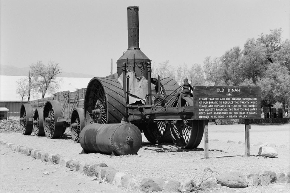
    By the late 1890s, the Borate mine near Calico produced thousands of tons of ore annually. Initially, borax was transported to the railhead at Daggett by 20-mule teams, a slow and costly process. An attempt to replace the teams with a steam-powered traction engine named “Old Dinah” failed due to the desert terrain, leading to the innovative solution of building a narrow-gauge railroad. This marked a significant transition from traditional mule team freighting to a more efficient rail-based network, reducing costs and modernizing transport.

    Construction of the Borate & Daggett Railroad (1898)

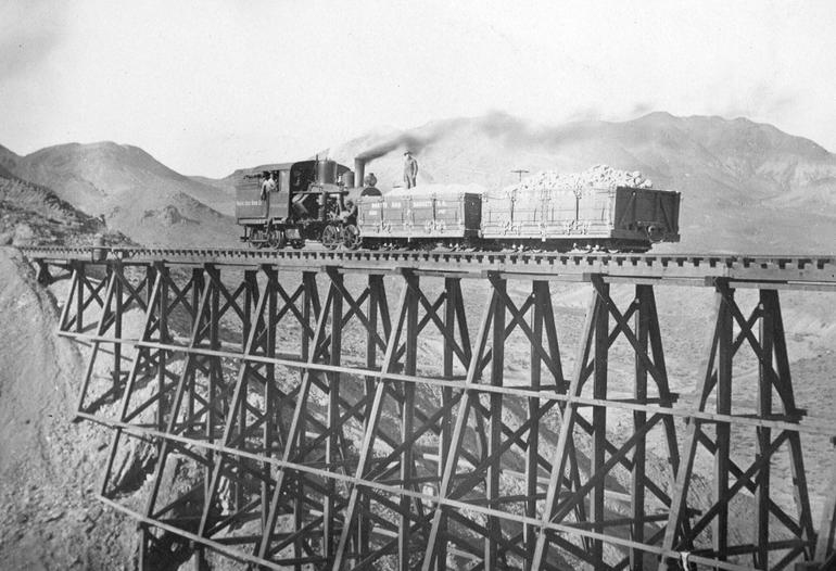
    The railroad was completed in 1898, running 11 miles from Daggett to Borate through Mule Canyon. It used a 3-foot gauge track with steep grades and trestles to navigate the rugged terrain. Two Heisler steam locomotives, “Marion” and “Francis,” handled the ore trains. A roasting mill was built midway at a Marion site to process the ore before shipment, and a third rail allowed standard-gauge boxcars to be loaded there.

    Operations and Infrastructure

    The railroad regularly hauled borax ore to Daggett, where workers reloaded it into Santa Fe Railway cars for transport. The system improved efficiency, replacing the mule teams entirely and reducing costs. The mill at Marion roasted and sacked the ore, streamlining shipment by loading directly into standard-gauge cars.

    Replacing the Twenty-Mule Teams

    The railroad’s completion in 1898 marked the end of the mule team era for borax hauling in the Calico region. Daggett, once a hub for mule teams, evolved into a rail center. The shift to rail transport significantly increased output and reliability for the Pacific Coast Borax Company.

    Expansion to Death Valley:

    The Tonopah & Tidewater Railroad By 1904, ore quality at Borate declined. Smith turned to the Lila C Mine near Death Valley, discovered richer deposits, and began building the standard-gauge Tonopah & Tidewater Railroad in 1905. By 1907, the new line reached Death Valley Junction, prompting the shutdown of the Borate & Daggett line. Operators relocated all activities north, resulting in the abandonment of the narrow-gauge line.

    The Death Valley Railroad, built in 1914, served the new mines at Ryan, CA. It connected to the Tonopah & Tidewater at Death Valley Junction. Equipment from the Borate & Daggett line, including its locomotives, was reused during construction. The Borate & Daggett, Tonopah & Tidewater, and Death Valley railroads formed a network supporting the borax industry across eastern California and Nevada.

    Decline and Abandonment

    In 1907, they abandoned the Borate & Daggett Railroad, removed the tracks, and relocated or stored the equipment. The Borate mine and camp stood deserted, while Daggett’s narrow-gauge facilities lay unused. Workers later moved a locomotive repair shop from the line to Daggett and repurposed it.

    Legacy and Remnants Today

    Even though the railroad has been gone for over a century, off-roaders still use the route through Mule Canyon, where you can see remnants of trestles and the old roadbed. Ruins and mine openings still mark the Borate townsite. A historic garage built from the original repair shop still stands in Daggett. Death Valley museums showcase artifacts like Old Dinah and original 20-mule team wagons.

    The Borate & Daggett Railroad helped usher in a new era of borax mining, replacing animal transport with rail efficiency. Its brief life laid the groundwork for a more extensive borax rail network, which was crucial in the history of desert mining.

  • The Story of Garces Rock

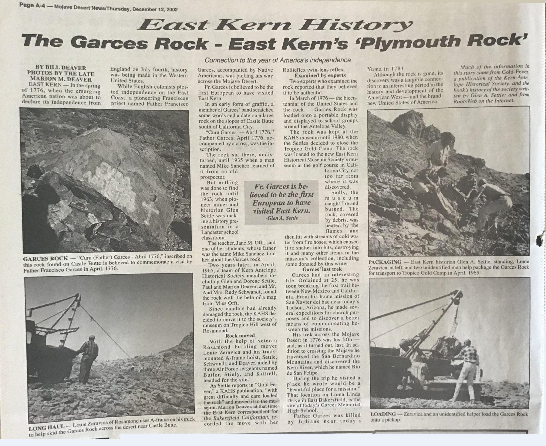
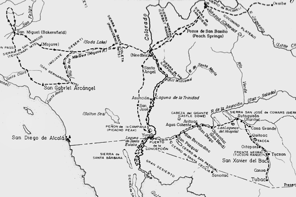
    In the spring of 1776, while revolution stirred on the East Coast, something quieter, though no less meaningful, was happening far in the West. A Spanish Franciscan missionary, Father Francisco Garces, was on his fifth and final journey into the heart of what is now California.

    Guided by Native people and traveling by foot and mule, Father Garces came up through the Antelope Valley, tracing ancient indigenous trails through uncharted territory to Europeans. From there, he pressed on into the San Joaquin Valley, turned east and crossed the rugged mountains near Tehachapi, and continued into the dry interior, heading toward the Mojave River.

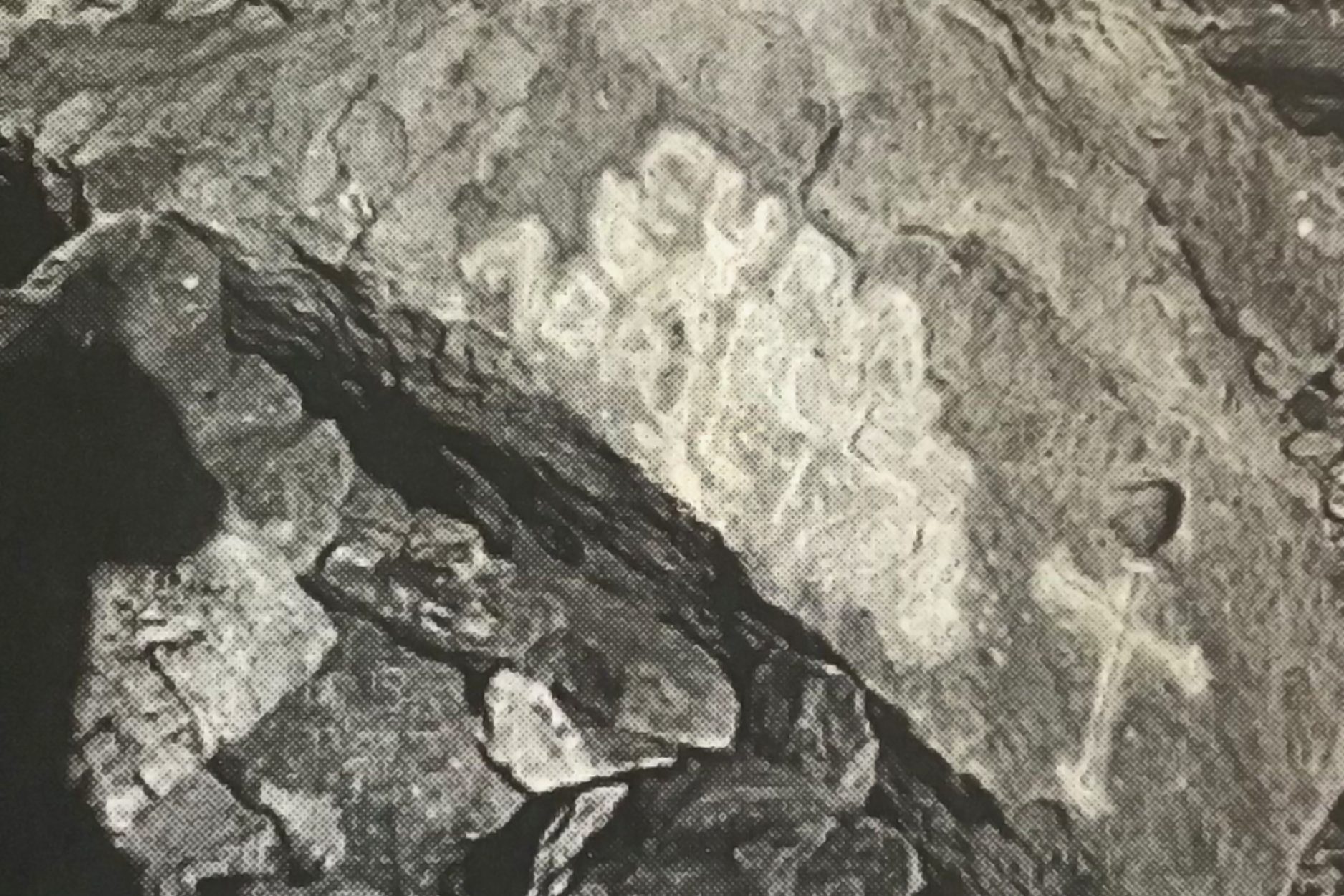
    During this leg of the journey, near the base of Castle Butte, east of present-day California City, someone in his party left behind a quiet message. Carved into a large boulder was a simple inscription:
    “Cura Garces – Abril 1776.”
    A trace is left in stone to mark their passage through the high desert.

    That rock sat in silence for more than 150 years. Then, around 1935, an old prospector pointed it out to a man named Mike Sanchez, but the story of the stone didn’t go far. Sanchez wasn’t much of a talker, and the tale faded.

    Later, in 1963, local historian Glen Settle gave a talk at an elementary school in Lancaster. A teacher there told him about the rock. One of her students—Mike Sanchez’s son—had shared the story, and he even had a hand-drawn map.

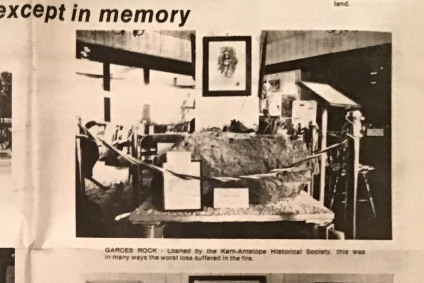
    Two years later, in 1965, Settle and several other members of the Kern Antelope Historical Society followed that map and found the rock. It had already suffered some vandalism, so the group relocated it to a safe location. They called in a local man with a truck and a sturdy A-frame hoist. With help from a few Air Force sergeants, they carefully transported the rock to the Tropico Gold Camp Museum in Rosamond.

    They brought in experts to study it. One priest, an authority on early Spanish California, confirmed that the words and cross were consistent with 18th-century Franciscan markings. The weathering on the carving was old, possibly as old as Garces’ journey.

    During the 1976 U.S. Bicentennial, organizers mounted the rock on a traveling display. They showed it at schools and events throughout the Antelope Valley. It was a rare, tangible link between the Mojave Desert and the very year the United States was born.

    In 1979, the rock was loaned to the new East Kern Historical Museum in California City, close to where it had first rested centuries earlier.

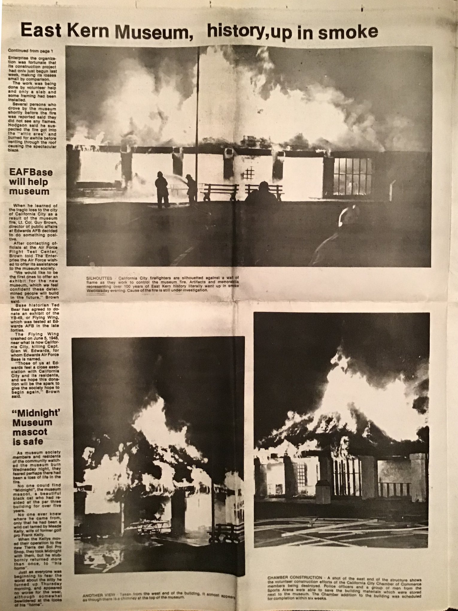
    Then, tragedy struck in the dark hours of February 4, 1981. The museum caught fire. Local fire crews responded quickly, but upon arrival, the wooden structure was already fully engulfed in flames.

    At first glance, the Garces Rock seemed to have survived the blaze. But it crumbled into fragments when someone gently touched it the next morning. The heat from the fire, followed by cold water from the hoses, had cracked and fractured the boulder beyond saving—even the carved inscription dissolved into dust.

    Firefighters did everything they could. There was nothing left.

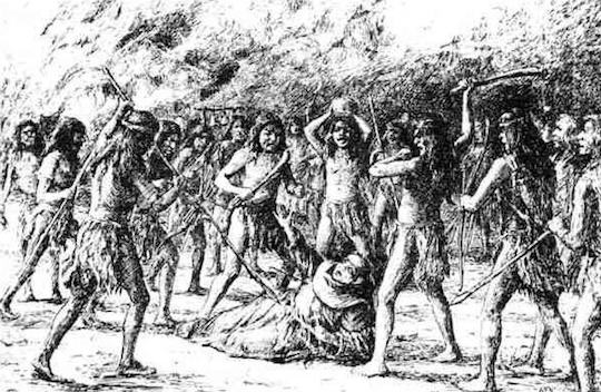
    What was lost that night wasn’t just a rock. It was a rare and quiet witness to a moment of deep historical significance—when a European missionary followed Native guidance across the mountains, valleys, and deserts of early California.

    Father Garces didn’t live long after his desert crossing. He was killed near the Colorado River in 1781, near what is now Yuma, Arizona. But his name still lives on in places like Garces Memorial High School in Bakersfield—built near the spot he once called a “beautiful place for a mission.”

    Though the rock is gone, the story remains. It’s kept alive by teachers, old-timers, maps passed down, and folks who care enough to remember. It’s proof that sometimes the desert whispers back—and if you listen closely, you can still hear the footsteps of history echoing through the sand.