Tag: san bernardino mountains

  • The Cushenbury Grade

    The Cushenbury Grade is a steep and winding stretch of mountain road that climbs from the high desert of Lucerne Valley up to the pine-covered town of Big Bear Lake. Today, it’s part of California State Route 18, but long before pavement and guardrails, this canyon trail served miners, ranchers, and Native travelers through the San Bernardino Mountains.

    Before roads were built, the Serrano people used footpaths through Cushenbury Canyon to move between desert and mountain environments. These routes followed natural contours through the rugged terrain and were later adopted by settlers.

    By the 1860s and 70s, prospectors, cattlemen, and freighters were dragging wagons up and down this slope. During the gold boom in nearby Holcomb Valley, Cushenbury became one of the main north-side routes into Big Bear. It was grueling work—steep grades, loose rock, and no guarantee your wagon would make it to the top in one piece.

    The canyon and grade took their names from the Cushenbury family, early settlers and cattle ranchers in the Lucerne Valley area. Their name stuck, and by the early 20th century, the area gained new attention, not for gold but for limestone.

    In 1918, rich limestone and marble deposits were discovered along the grade. This sparked industrial interest, and by the 1950s, Kaiser Cement had developed a massive limestone quarry near the top. A narrow-gauge rail system carried raw material down the grade to a processing plant: even today, trucks loaded with cement rumble up and down the slope.

    During the 1960s, the state upgraded the road and officially folded it into California State Route 18. This brought pavement, safety improvements, and better access to Big Bear from the desert side. Though safer now, the grade still features tight switchbacks and dramatic elevation changes, rising from about 3,000 feet in Lucerne Valley to over 6,700 feet at the top.

    Today, the Cushenbury Grade remains a key route for both commerce and recreation. It offers expansive views of the Mojave Desert below and a sense of just how much effort it once took to reach the mountains. Whether hauling limestone or heading up for a weekend getaway, this road directly links two very different worlds—desert and alpine.

    Timeline

    Cushenbury Grade Historical Timeline

    Pre-1800s:
    Indigenous Serrano people use Cushenbury Canyon as a seasonal travel route between the Mojave Desert and mountain forests.

    1860s–1870s:
    Miners and ranchers began traveling through the canyon using rough trails to access Holcomb Valley and Big Bear. The steep terrain made it tough for freight wagons and livestock.

    1880s:
    A more defined wagon road is carved into the canyon wall. It’s still rough going—narrow, rocky, and dangerous—but it’s one of the few ways into Big Bear from the desert.

    Early 1900s:
    The Cushenbury family settles in the Lucerne Valley area, giving their name to the canyon and grade.

    1918:
    Limestone and marble are discovered along the canyon. As mining gains momentum, the area shifts from wagon trail to industrial corridor.

    1950s:
    Kaiser Cement develops a large limestone quarry near the top of the grade. A private rail system is built to haul material to the desert floor. This leads to improvements along the road.

    1960s:
    The state paves and upgrades the road, officially making it part of California State Route 18. It becomes a year-round access route to Big Bear Lake from the high desert.

    1990s–present:
    The Cushenbury Grade is heavily used by cement trucks and tourists. The steep climb and sharp turns remain challenging, especially in winter, but it’s a vital link between two different environments.
  • Mojave River

    The Mojave River is a strange, beautiful thread of water in California’s high desert. Most of the time, you can’t see it. It hides beneath the sand, popping up only in rare places like Afton Canyon or the Narrows near Victorville. But this ghost river has a long and complicated past tied to shifting earth, ancient climates, lost lakes, and generations of people who relied on it.

    It all began millions of years ago when tectonic forces pushed up the San Bernardino and San Gabriel Mountains. These rising peaks blocked older river systems that used to flow toward the Pacific. With nowhere to go, water from the mountains started pooling in the desert. Over time, a new river formed, trapped within these closed desert basins. That was the beginning of the Mojave River.

    During the Ice Age, things looked very different. The Mojave River wasn’t just a trickle or an underground stream—it was a robust river that flowed year-round, fed by rain and snowmelt from the mountains. It carried water from the San Bernardino Mountains to a series of massive lakes out in the desert: Lake Manix near Barstow and Lake Mojave farther east. These were deep, wide bodies of water teeming with life. Around 18,000 years ago, Lake Manix overflowed, carving the dramatic Afton Canyon and sending a flood of water toward Soda and Silver Lakes, which became Lake Mojave. Fossils from this time show mammoths, saber-toothed cats, and even aquatic life like fish and freshwater snails around the river and lakes.

    When the last Ice Age ended, the climate changed. It got warmer and drier, and the big lakes began to dry up. The river still carried water now and then, but only during the wet season, and it often disappeared underground. Over thousands of years, it became the ghost river we know today. Now, it flows mostly beneath the desert floor, surfacing briefly after storms or in spots where rock formations push it upward.

    Despite its dryness, the Mojave River is the lifeblood of the western Mojave Desert. Its rare surface flows and hidden undercurrents recharge underground aquifers, feed oases, and support all kinds of desert life. You’ll find cottonwood trees, willows, and even small fish like the endangered Mojave tui chub in wetter stretches. Birds rely on it too, especially migratory species that need stopover habitat in the middle of a dry land. Some stretches, like Palisades Ranch and Afton Canyon, are rich in wildlife because of the river’s presence.

    People have followed the Mojave River for thousands of years. Indigenous groups, especially the Vanyume (a branch of the Serrano), lived along its banks and used its waters to survive in the desert. It also became part of significant trade and travel routes, notably the Mojave Road. Spanish explorers like Father Garces followed it in 1776, and American mountain men like Jedediah Smith came through in the 1820s. Later, Mexican traders and Mormon pioneers used it to reach California.

    In the 20th century, towns like Victorville, Barstow, and Daggett grew along the river. They pulled water from its aquifer for agriculture and homes. Over time, more groundwater was pumped out—more than was going back in. This led to water shortages and falling water tables. To fix it, water agencies began regulating pumping and importing water from Northern California to recharge the Mojave Basin. Today, the Mojave Water Agency closely monitors the river’s underground flow.

    Climate change is also reshaping the river’s future. Bigger storms could cause major flooding, but longer droughts make the river even more fragile. Meanwhile, conservation groups are working to protect the remaining green places along the river—removing invasive tamarisk, planting native trees, and safeguarding habitat for birds, fish, and other wildlife.

    So while the Mojave River may not look like much at first glance—just a dry wash running through the desert—it’s the thread that ties together this region’s natural and human story. From Ice Age megafauna to modern groundwater battles, the Mojave River has quietly shaped life in the desert for millennia.

    Sources: https://pubs.usgs.gov/of/2004/1007/mojave/index.htm – USGS: Mojave River Geologic Framework and Groundwater Flow https://pubs.er.usgs.gov/publication/wri024280 – USGS Water Resources Investigations: Mojave River Flow System https://mojavedesert.net/mojave-river/ – Digital Desert: Overview and History of the Mojave River https://digital-desert.com/mojave-river/ – Digital Desert: Detailed Description of the Mojave River Course and Features https://digital-desert.com/mojave-river/east-fork/ – Digital Desert: East Fork of the Mojave River https://digital-desert.com/mojave-river/west-fork/ Digital Desert: West Fork of the Mojave River https://digital-desert.com/natural-mojave-river/ – Digital Desert: The Natural Mojave River https://www.blm.gov/visit/afton-canyon – BLM: Afton Canyon Natural Area https://www.mojavewater.org/ – Mojave Water Agency: Groundwater Management and River Info https://westernrivers.org/where-we-work/california/mojave-river – Western Rivers Conservancy: Mojave River Conservation Projects https://www.mdlt.org/ – Mojave Desert Land Trust: Mojave River Habitat Protection https://nrm.dfg.ca.gov/FileHandler.ashx?DocumentID=83982 – CDFW: Camp Cady Wildlife Area Management Plan https://www.fs.usda.gov/Internet/FSE_DOCUMENTS/fseprd493364.pdf – USDA: Mojave River Watershed Assessment https://en.wikipedia.org/wiki/Mojave_River – Wikipedia entry with references on river history, hydrology, and human use

  • The Road That Gold Built

    The Story of Van Dusen Road and Belleville

    In the spring of 1860, Bill Holcomb struck gold in a high mountain valley north of today’s Big Bear Lake. Word spread fast. By summer, a stampede of prospectors poured into what came to be known as Holcomb Valley, setting up tents, cabins, and mining claims. They hit pay dirt—some called it the richest gold strike in Southern California.

    The mining camp that sprang up didn’t stay small for long. They named it Belleville, not after some prospector or politician, but after a baby—Belle Van Dusen, the newborn daughter of Jed Van Dusen, the town blacksmith. Her mother had sewn a makeshift American flag for the Fourth of July out of a miner’s shirt and a red petticoat, and the miners, feeling patriotic and maybe a little sentimental, gave the town her name.

    Belleville boomed overnight. By the end of 1860, the town had thousands of residents—some say more than anywhere in the county except San Bernardino. The place had everything a gold camp needed: saloons, gambling halls, blacksmith shops, general stores, butcher shops, and a dance hall called the Octagon House. Of course, with that many miners and not much law, trouble came with it—shootouts, lynchings, and outlaw gangs made Belleville a wild place.

    But there was a problem. The town was rich in gold and short on everything else, especially food and supplies. The only way in was by pack mule. Wagons couldn’t get through. If you wanted to bring a wagon to Holcomb Valley, you had to take it apart and haul it in pieces.

    So the miners did something about it. They didn’t wait for the government. They scraped together about $2,000 in gold dust and hired someone they trusted: Jed Van Dusen. He was handy with tools, was already running the blacksmith shop, and knew the country. Jed built a wagon road from Belleville down the mountain toward the desert, connecting it with a new toll road through Cajon Pass built by John Brown Sr., another early pioneer.

    Van Dusen’s road, finished in 1861, made all the difference. Wagons could reach Holcomb Valley from San Bernardino through Cajon Pass and Deadman’s Point. Supplies started flowing in: food, lumber, mining gear, blasting powder—even whiskey for Greek George’s saloon. Stagecoaches came too. What had taken a week by mule could now be done in two days by wagon.

    That road helped Belleville grow even faster. Miners brought in stamp mills to crush rock and moved from panning in streams to blasting gold out of hard rock. Belleville got so bold it tried to steal the county seat from San Bernardino. In the 1860 election, it nearly succeeded—some say it did win, but one of the Belleville ballot boxes mysteriously ended up in a bonfire.

    Of course, what goes up in gold country usually comes down just as fast. The easy gold dried up. The winter of 1861–62 was brutal—deep snow cut off the town for weeks. Miners left, saloons shut down, and Belleville started to fade. By 1864, it was nearly a ghost town.

    But Van Dusen’s road stuck around. Even after Belleville was gone, the road he built continued to serve the area. Ranchers used it for cattle drives, loggers hauled timber down it, and the Forest Service later turned parts into official roads and ranger stations.

    Today, the road still exists as Forest Service Road 3N09. Adventurous drivers can still follow the route Jed built by hand, more than 160 years ago. And if you walk through Holcomb Valley, you’ll find a few signs and stones where Belleville once stood—a rough mining town that burned bright and fast, and a road built by a blacksmith whose daughter gave the place its name.

  • The Old Spanish Trail had become increasingly used as a pack mule trail between New Mexico and California, and with this traffic came the opportunity for those to take advantage of the distance and desperate nature of the land.

    Crowder (Coyote) Canyon in the Cajon Pass north of San Bernardino
    Hundreds and sometimes even thousands of stolen horses from the ranchos would burst through Coyote Canyon beginning their ‘journey of death’ across the Mojave.

    California horses were beautiful creatures, and the mules were taller and stronger than those in New Mexico and they were easy to steal.  The rolling hills and plains presented clear paths to the  Cajon where numerous hidden canyons and washes were available to slip into and prepare for the furious run across the desert. Horses would be stolen in herds from many different ranchos at once. Hundreds of horses, even thousands could be commandeered and driven by just a few experienced thieves.

    Narrows, Crowder Cyn., Cajon Pass

    Chief Walkara, ‘Hawk of the Mountains’ and the greatest horse thief in all of history along with his band of renegade Chaguanosos , and notables such as Jim Beckwourth and Pegleg Smith would work together in this illegal trade. During one raid they were said to have coordinated the theft of 3,000-5,000 horses, driving them to Fort Bridger to trade for more horses to run to New Mexico to trade again. Horses would fall from exhaustion every mile and the local bands of Paiute would feast on the remains.

    The rich ranchos of southern California.

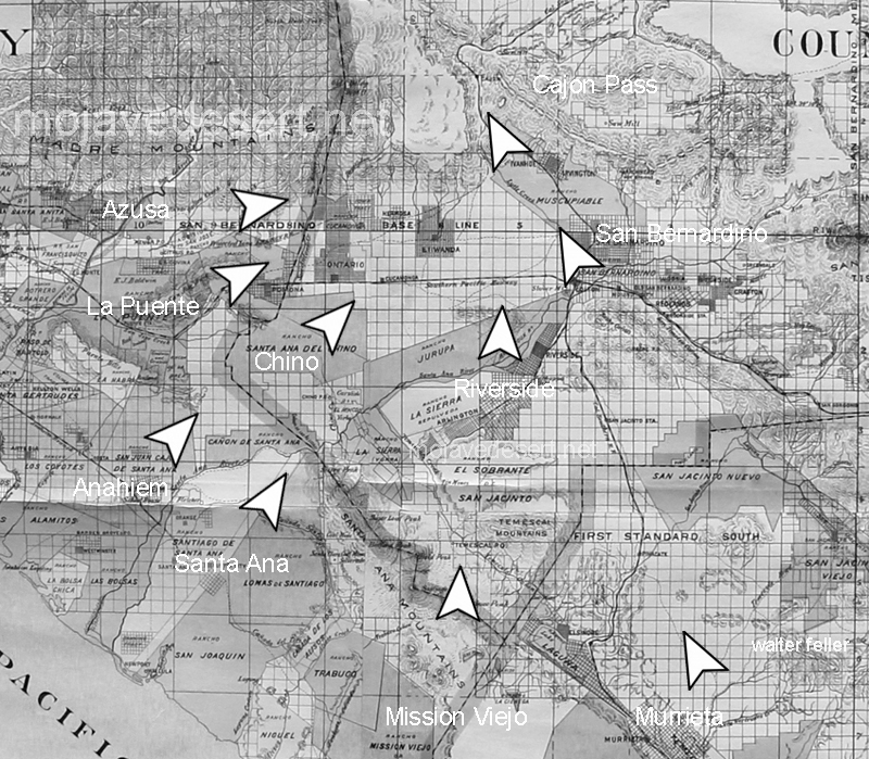
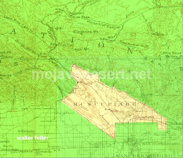
    In 1843 Michael White was granted one league of land at the mouth of the Cajon Pass called Rancho Muscupiabe. At a point overlooking the trails leading into and away from the canyon he was expected to thwart the raiders and horse thieves that were plaguing the Southern California ranchos. In theory it was a good plan but in practice it did not work so well.

    Devore, ca.
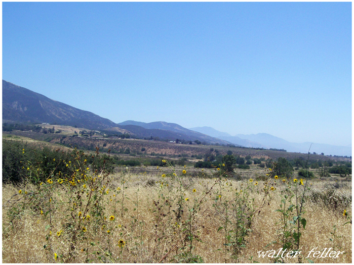
    From the piedmont between Devil and Cable canyons, Miguel Blanco could keep an eye out for the horse thieves entering the Cajon.

    He built his home of logs and earth and constructed corrals for his stock. However, the location between Cable and Devil Canyon only served as a closer and more convenient target for the Indian thieves. His family was with him, but after six weeks until it became too dangerous. He left after nine months without any livestock and in debt.

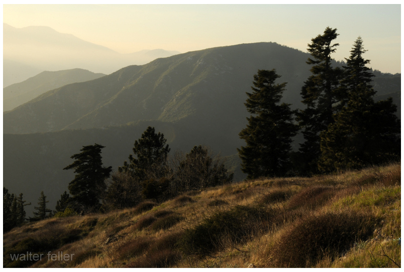
    The Old Spanish Trail went down this slope to behind Miguel Blanco’s rough-hewn homestead. Indians would watch from this forest for Miguel to leave and they would slip down and steal everything that could be stolen.

    Miguel sold his property, however, Miguel had misread the grant, letting the rancho go for much less than it was worth. The land described on the grant was roughly 5 times larger than Miguel thought.  Blanco brought a suit but lost.

    Muscupiabe Rancho, Michael White, Miguel Blanco
    Muscupiabe Rancho

    As the late 1840s and 1850s rolled by wagon roads were being developed in the canyon minimizing the effectiveness of the maze of box canyons being used to cover the escape of desperadoes on horseback. With California becoming a state frontiersmen such as Beckwourth and Peg Leg Smith would not steal from fellow Americans. Horse-thieving under U.S. law had become a crime where before it was just stealing horses from Mexicans. That was only serious if caught in the act. Americans would never extradite them. For the most part, that was the end of the horse stealing raids.

    • end
  • Victor Valley Crossings

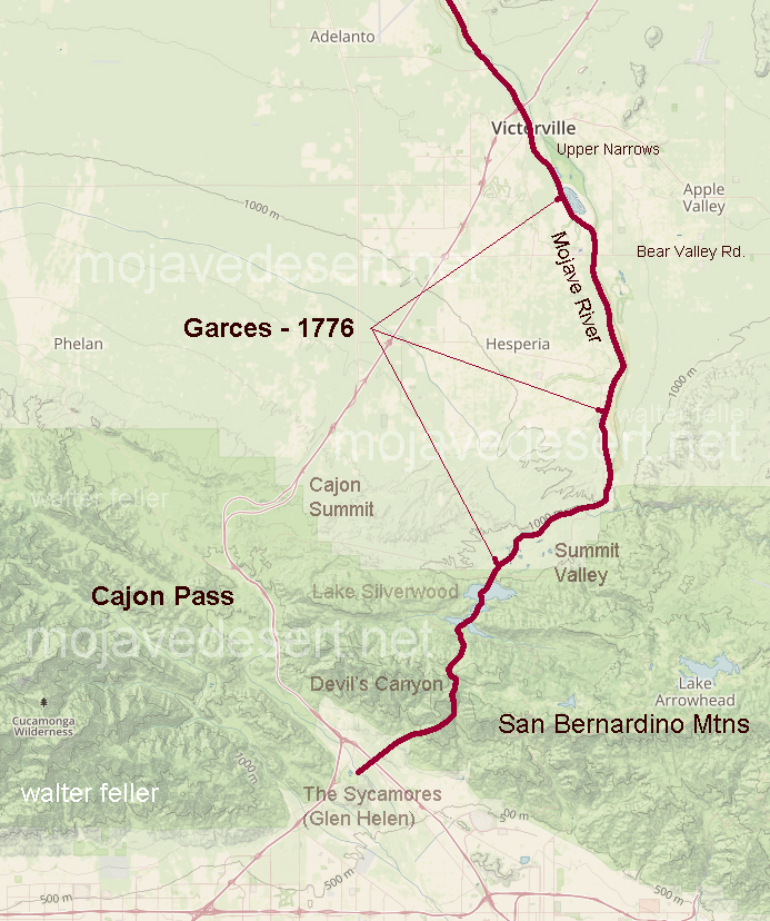
    Fr. Francisco Hermenegildo Tomás Garcés (April 12, 1738 – July 18, 1781) was a Spanish priest who crossed the Mojave Desert in 1776. This map shows his route across the Victor Valley. Following the Mojave River after crossing at Oro Grande, he walked through downtown Victorville, bypassing the rocky narrows and connecting with the river near today’s Mojave Narrows Regional Park. Following the river to where the West fork and Deep Creek join to form the Mojave. He visited with the Indians and then went up Sawpit Canyon and over the mountain ridge, descending into the verdant sycamore grove known today as Glen Helen.

    This map shows Fr. Garces’s route in 1776 during his crossing west. His diary describes him being taken to an Indian village in the mountains.

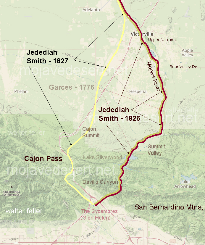
    Fifty years after Fr. Garcés made his way across the Mojave from the Colorado River, in 1826, Jedediah Smith retraced the trail of Garcés along the river, then up and over the mountains. In 1827, one year after his first crossing, Smith had lost most of his men in a massacre at the Colorado River. Desperate for the safety of civilization, Smith, after crossing the Mojave River in Oro Grande, made his way directly to the Cajon Pass, bypassing the San Bernardino Mountains.

    The direct route over the summit and down the pass eliminates the steep climb and descent over the San Bernardino Mountains.