Tag: Victor Valley

  • Mojave River

    The Mojave River is a strange, beautiful thread of water in California’s high desert. Most of the time, you can’t see it. It hides beneath the sand, popping up only in rare places like Afton Canyon or the Narrows near Victorville. But this ghost river has a long and complicated past tied to shifting earth, ancient climates, lost lakes, and generations of people who relied on it.

    It all began millions of years ago when tectonic forces pushed up the San Bernardino and San Gabriel Mountains. These rising peaks blocked older river systems that used to flow toward the Pacific. With nowhere to go, water from the mountains started pooling in the desert. Over time, a new river formed, trapped within these closed desert basins. That was the beginning of the Mojave River.

    During the Ice Age, things looked very different. The Mojave River wasn’t just a trickle or an underground stream—it was a robust river that flowed year-round, fed by rain and snowmelt from the mountains. It carried water from the San Bernardino Mountains to a series of massive lakes out in the desert: Lake Manix near Barstow and Lake Mojave farther east. These were deep, wide bodies of water teeming with life. Around 18,000 years ago, Lake Manix overflowed, carving the dramatic Afton Canyon and sending a flood of water toward Soda and Silver Lakes, which became Lake Mojave. Fossils from this time show mammoths, saber-toothed cats, and even aquatic life like fish and freshwater snails around the river and lakes.

    When the last Ice Age ended, the climate changed. It got warmer and drier, and the big lakes began to dry up. The river still carried water now and then, but only during the wet season, and it often disappeared underground. Over thousands of years, it became the ghost river we know today. Now, it flows mostly beneath the desert floor, surfacing briefly after storms or in spots where rock formations push it upward.

    Despite its dryness, the Mojave River is the lifeblood of the western Mojave Desert. Its rare surface flows and hidden undercurrents recharge underground aquifers, feed oases, and support all kinds of desert life. You’ll find cottonwood trees, willows, and even small fish like the endangered Mojave tui chub in wetter stretches. Birds rely on it too, especially migratory species that need stopover habitat in the middle of a dry land. Some stretches, like Palisades Ranch and Afton Canyon, are rich in wildlife because of the river’s presence.

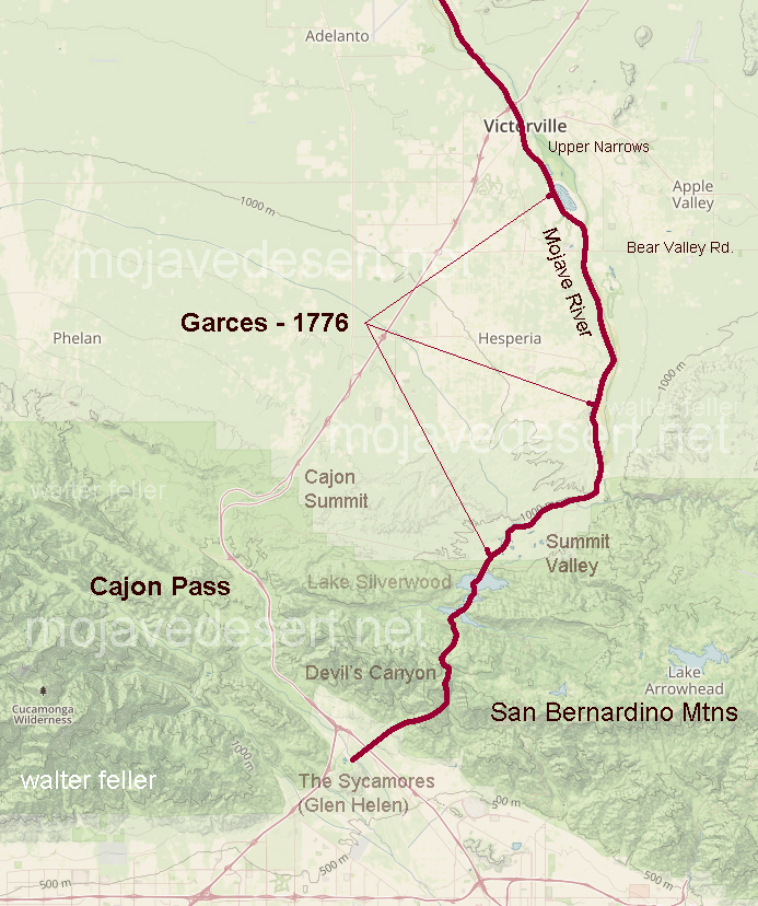
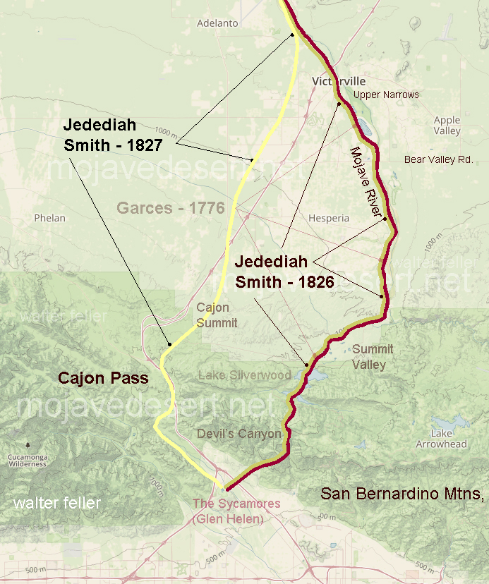
    People have followed the Mojave River for thousands of years. Indigenous groups, especially the Vanyume (a branch of the Serrano), lived along its banks and used its waters to survive in the desert. It also became part of significant trade and travel routes, notably the Mojave Road. Spanish explorers like Father Garces followed it in 1776, and American mountain men like Jedediah Smith came through in the 1820s. Later, Mexican traders and Mormon pioneers used it to reach California.

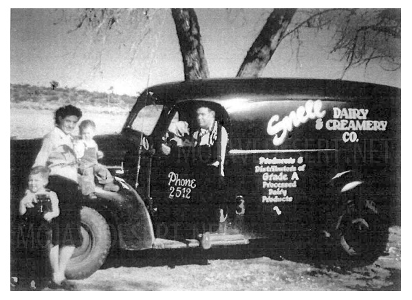
    In the 20th century, towns like Victorville, Barstow, and Daggett grew along the river. They pulled water from its aquifer for agriculture and homes. Over time, more groundwater was pumped out—more than was going back in. This led to water shortages and falling water tables. To fix it, water agencies began regulating pumping and importing water from Northern California to recharge the Mojave Basin. Today, the Mojave Water Agency closely monitors the river’s underground flow.

    Climate change is also reshaping the river’s future. Bigger storms could cause major flooding, but longer droughts make the river even more fragile. Meanwhile, conservation groups are working to protect the remaining green places along the river—removing invasive tamarisk, planting native trees, and safeguarding habitat for birds, fish, and other wildlife.

    So while the Mojave River may not look like much at first glance—just a dry wash running through the desert—it’s the thread that ties together this region’s natural and human story. From Ice Age megafauna to modern groundwater battles, the Mojave River has quietly shaped life in the desert for millennia.

    Sources: https://pubs.usgs.gov/of/2004/1007/mojave/index.htm – USGS: Mojave River Geologic Framework and Groundwater Flow https://pubs.er.usgs.gov/publication/wri024280 – USGS Water Resources Investigations: Mojave River Flow System https://mojavedesert.net/mojave-river/ – Digital Desert: Overview and History of the Mojave River https://digital-desert.com/mojave-river/ – Digital Desert: Detailed Description of the Mojave River Course and Features https://digital-desert.com/mojave-river/east-fork/ – Digital Desert: East Fork of the Mojave River https://digital-desert.com/mojave-river/west-fork/ Digital Desert: West Fork of the Mojave River https://digital-desert.com/natural-mojave-river/ – Digital Desert: The Natural Mojave River https://www.blm.gov/visit/afton-canyon – BLM: Afton Canyon Natural Area https://www.mojavewater.org/ – Mojave Water Agency: Groundwater Management and River Info https://westernrivers.org/where-we-work/california/mojave-river – Western Rivers Conservancy: Mojave River Conservation Projects https://www.mdlt.org/ – Mojave Desert Land Trust: Mojave River Habitat Protection https://nrm.dfg.ca.gov/FileHandler.ashx?DocumentID=83982 – CDFW: Camp Cady Wildlife Area Management Plan https://www.fs.usda.gov/Internet/FSE_DOCUMENTS/fseprd493364.pdf – USDA: Mojave River Watershed Assessment https://en.wikipedia.org/wiki/Mojave_River – Wikipedia entry with references on river history, hydrology, and human use

  • The Black Bridge

    Railroad bridge Victorville, Mojave River

    “One of Victor’s (Jacob Nash Victor) greatest contributions was supervision of a number of bridges constructed in San Bernardino County. The first and longest of these was the railroad crossing of the Mojave River in the lower narrows. It is not known just how directly involved he or Perris (Fred T. Perris) were with this project, since their correspondence includes a letter regarding recommendation from New England of another engineer-bridge builder anxious for employment just then. Whoever was directly responsible, huge granite blocks were shaped to fit snugly into cemented buttresses, which have not cracked or moved in over 100 years of continuous use and several devastating floods. The iron bridge, described as one of the finest structures of its kind on this coast, was brought in sections by railroad to Barstow and freighted from there to the site. This bridge was replaced early in the 20th century, including a second set of tracks, but the subsequent structures have all continued to utilize the same basic foundation buttresses. This would be the oldest structure in the region (the buttresses were built in 1885).”

    ~ History of the Victor Valley – Lyman
    Published by Mohahve Historical Society

  • The Walters Family

    The Walters family is an important part of Hesperia history.  Starting with George Francis Walters, who moved his family from Illinois to California because his wife, Harriet C Finigan Walters had asthma.

    Hesperia Hotel

    The family first settled in the Riverside area where he went to work for the Santa Fe Railroad. According to Bolton Minister, son of George O Walters Minister, George was offered a transfer to Hesperia to manage the Hesperia Hotel.

    The Walters family consisted of George and his wife Harriet, and their children, in birth order, Georgia Henry had to Walters Minister-Henry, Verial  W.  Walters Ormond and Roy Edward Walters.

    According to Mr. Minister, both the daughters went to work in the hotel. They were later joined by Laura McClanahan who in 1921 transferred from the Goodsprings Hotel,   in Goodsprings,  Nevada.

    Roy & Laura Walters

    Verial  was postmistress, until she moved away when she got married, and then her position was given to her brother Roy.

    Roy ended up marrying Laura McClanahan and having a daughter, Geraldine Henrietta Walters.  Geraldine married first, Yeager  and second Schwartz.

    According to Mr. Minister,  George Francis Walters built the Walters house in the Walters general store according to Geraldine, her grandmother Harriet was the midwife in the delivery of 32 Hesperia babies.

    When George passed away the store was handled over to Roy, who operated it for many years.

    I do not know where George and area Walters or Barry. However, I do know that Roy and Laura are buried at the cemetery in Victorville.

    With the passing of time, their store had deteriorated and will eventually disappear from Hesperia. As eventually, the Walters name will.

    Hesperia California
    Pre 1950

    Then and Now

    by Mary Ann Creason Dolan Rhode

  • Victor Valley Crossings

    Fr. Francisco Hermenegildo Tomás Garcés (April 12, 1738 – July 18, 1781) was a Spanish priest who crossed the Mojave Desert in 1776. This map shows his route across the Victor Valley. Following the Mojave River after crossing at Oro Grande, he walked through downtown Victorville, bypassing the rocky narrows and connecting with the river near today’s Mojave Narrows Regional Park. Following the river to where the West fork and Deep Creek join to form the Mojave. He visited with the Indians and then went up Sawpit Canyon and over the mountain ridge, descending into the verdant sycamore grove known today as Glen Helen.

    This map shows Fr. Garces’s route in 1776 during his crossing west. His diary describes him being taken to an Indian village in the mountains.

    Fifty years after Fr. Garcés made his way across the Mojave from the Colorado River, in 1826, Jedediah Smith retraced the trail of Garcés along the river, then up and over the mountains. In 1827, one year after his first crossing, Smith had lost most of his men in a massacre at the Colorado River. Desperate for the safety of civilization, Smith, after crossing the Mojave River in Oro Grande, made his way directly to the Cajon Pass, bypassing the San Bernardino Mountains.

    The direct route over the summit and down the pass eliminates the steep climb and descent over the San Bernardino Mountains.

  • $150,000 Summit Road Route Being Considered

    Summit Valley Road
    Summit Valley Road

    State Highway Commissioner Darlington has under advisement the matter of which route to choose for the 15-mile state highway to be built from Summit to Victorville at a cost of $150,000.  A delegation headed by Louis Evans of Hesperia asked Darlington to choose the route that would include Hesperia on the highway.

    Los Angeles Herald, Number 58, 8 January 1919

  • Farmland – Oro Grande

    Farmland in Oro Grande along the Mojave River
    Farmland in Oro Grande

    “During his years at the upper crossing, Captain Lane, as Aaron was known throughout much of his life in California, had ample opportunity to discover where the richest farmlands lie along the Mojave River.”

    Pioneer of the Mojave – Green Gold and Mint Juleps

  • Riverside Cement – Oro Grande

    Oro Grande Riverside cement plant, Victor Valley, Mojave Desert

    Riverside Cement in Oro Grande, CA started in 1907 as the Golden State Cement Plant. It was shut down during the depression and restarted as Riverside Cement in 1942. The plant was enlarged and completely rebuilt in the late 40s. In late 1997, TXI purchased Riverside Cement.

    More about Oro Grande

  • Special Delivery

    Hesperia, CA.  pre-1950 – Then and Now

    Jack and Margaret Nelson, were a very nice couple, who lived on the corner of Olive and E Street. They had three dogs, two were copper-colored police dogs, named Penny and Copper, and one chow dog, named sugar. My parents became very good friends with them. They had a cow, and we soon started buying our milk from them, until they moved away.

    After the Nelsons left the area we started purchasing our melt from the Snell Dairy and Creamery Company that was located in Apple Valley. Dick and Winnie Weening took over the milk routes, serving all the high desert, as far as State Line in 1942. In 1943, the Weening family purchased the dairy and the name of Snell Dairy.  The milk was delivered in glass bottles and the empty bottles were picked up with the next delivery. The milkman would even put the full milk bottles in the refrigerator.  There will never be service like that again.
    599-snell-dairy-hesperia
    This photo was taken in 1945 or 1946, and was provided by Barbara Weening Davisson, daughter of Dick and Winnie Weening. She notes, that the picture is of the Johnny Weening, driver and Iva Weening Carpenter, with son Jerry (standing), Phil McGurn, being held.

    ~ Mary Ann Creason Dolan-Rohde

    More about …
    Hesperia, California

  • Walters’ General Store

    We did what shopping money would allow, at Roy Walters’ general store. We purchased some beans, flour and canned food items, (canned tuna for my mother and me and canned sardines were for my daddy) gas for the vehicle, and I remember ice for the icebox and we also picked up our mail. The post office was located inside of the store, in our mailing address was PO Box 166, Hesperia, CA. There were no ZIP Codes back in those days.
    599-walters-r6533
    The store was indeed a general store. They carried just about everything a person would need. There was a glass enclosed section that had any candy, which always drew my attention. There was a very large glass jar that sat on the counter that held dill pickles. I remembered these, because I liked both. There were shelves with items all the way from food, medicine, cosmetics two blankets. I remember a large cabinet that had a lot of small drawers, with labels on them. But I do not remember what was in the drawers. I think there were a couple wood barrels sitting on the floor and many items hanging on the walls. If I remember right, I think the butcher shop was located in the back of the store with a cold storage box to keep the meat from spoiling.. I do not remember if the bread was sliced. But I do remember that oleomargarine, (butter substitute) was non-colored and you had to mix a yellow powder packet into it, to make it yellow.

    There was a wooden barn that sat next to the store, where the hay and grain was stored. The gas pump was located in front of the store. I only remember one, but there must’ve been to. I am not sure what brand gas they sold. I do remember that you could buy oil for your vehicle or what equipment you might have at home. I do not remember, but going by the fact that the Walters store carry just about everything, I would guess they also sold batteries for your vehicle and equipment, else well as for your radio and flashlight.

    For the longest time, they had the only telephone in this area. And going by history, the railroad station had a telegraph office. The Hesperia depot set almost across the street from the store.

    Roy and Laura were both extremely friendly and up on the latest gossip. Roy loved to talk, and so did my daddy, so they would talk for what seemed like hours.

    Hesperia, CA.  pre-1950 – Then and Now
    ~ Mary Ann Creason Dolan-Rohde

    More about …
    Hesperia, California

  • The Railroad was Coming Through!

    Hesperia, was initially purchased in anticipation of the railroad coming through. Investors stood to make a nice profit from not only the railroad, but in the real estate near by as communities grew.Hesperia, Ca.

    Hesperia, Ca.

    But the railroad was built to Mojave, where trains could easily be routed southward toward Los Angeles, or over the Tehachapis, then north to San Francisco. The Hesperia investment languished and then was passed on to others. The railroad came through much later, but it was not so much of a big deal then.